Smarter transport solutions from TomTom

TomTom is introducing two novel products that help deliver smart traffic solutions, RoadDNA and its HAD map. The Road DNA will help make automated driving a reality, according to the firm. Designed with vehicle data storage and processing limitations in mind, RoadDNA delivers highly accurate location information that can easily be integrated into the onboard system of a vehicle. This allows a vehicle to continuously know exactly where it is located on the road. It offers highly accurate vehicle localisa
January 4, 2016 Read time: 2 mins
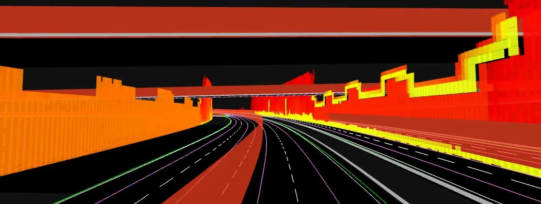
The TomTom technology provides a stepping stone for autonomous vehicle mdevelopment
3972 TomTom is introducing two novel products that help deliver smart traffic solutions, RoadDNA and its HAD map. The Road DNA will help make automated driving a reality, according to the firm. Designed with vehicle data storage and processing limitations in mind, RoadDNA delivers highly accurate location information that can easily be integrated into the onboard system of a vehicle.

This allows a vehicle to continuously know exactly where it is located on the road. It offers highly accurate vehicle localisation content in an efficient and cost-effective way. By matching RoadDNA data with vehicle sensor data in real-time, a vehicle knows its location on the road and even while travelling at high speeds or when changes occur to the roadside. But by converting a 3D point cloud of roadside patterns into a compressed, 2D view of the roadway, RoadDNA delivers a solution that needs little storage space and requires conventional processing requirements, without losing detail.

TomTom RoadDNA, combined with the TomTom HAD Map, delivers real-time information about a vehicle’s precise location on a map whilst coping with changes in the environment. The firm is also offering its HAD Map for Germany. This complete map of Germany covers the entire Autobahn network and provides a 3D lane map for 24,000km of roads.

The TomTom HAD Map for Germany provides accurate representation of 3D geometries of lane centrelines, lane dividers, road borders, and guard rails, as well as highlighting lane-dependent speed limits and lane divider marking types. In addition to enabling future self-driving cars to see beyond their sensors, the TomTom HAD map can also be used for advanced driving applications like improved versions of eco-adaptive cruise control (ACC), lane level guidance, and predictive powertrain control.

For more information on companies in this article

Related Content

  • Hot Bitumen Safety – Still an Issue, Eleven Years On
    April 22, 2016
    Despite clear industry guidelines published over a decade ago and revised in 2015, level measurement experts Hycontrol still regularly encounter asphalt plants with insufficient safety protocols for preventing spills of hot bitumen. Introduction – Bitumen Storage in the UK Recently-issued information from Eurobitume UK has reinforced the need for stringent safety precautions on sites with bitumen storage facilities; key amongst them being the implementation of a robust level monitoring and alarm system (‘Si
  • Innovative GIS software offerings
    July 18, 2012
    The latest construction software developments can speed the construction process overall, Adrian Greeman reports Construction software is by its very nature a very fast moving technology, with new systems coming to the market almost continuously. There are some key developments however, such as major new product launches and market trends. One of the most important developments in the road design sector is the launch of the Bentley Systems V8i versions of its software, including its road design applications
  • Vitronic at German test track
    January 7, 2022
    Vitronic has installed sensor technology along a designated Test Track for Automated and Connected Driving – TAVF – on a public road in Hamburg, Germany. This test installation aims to contribute to optimising traffic flow and increasing road safety, particularly vulnerable road users such as pedestrians and cyclists, on a busy road about 2km from the main railway station.
  • Sophisticated asphalt paving control technology
    July 27, 2020
    Advances in asphalt paving control systems are helping contractors deliver higher efficiency