SICK’s LMS 1000 and RMS 1000 sensors deliver the goods

SICK says that it’s recently launched LMS1000 and MRS1000 infrared LiDAR sensors deliver more accurate and reliable distance sensing and measurement, especially in difficult conditions. The robust, compact sensors weigh just 1.2kg and come with rotatable connectors for easy mounting on gantries. Heavy rain, mist, dust or snow can lead to false signals, explained Neil Sandhu, SICK’s national product manager for imaging, measurement, ranging and systems. The addition of SICK’s triple-echo HDDM+ - High Defini
January 7, 2019 Read time: 3 mins
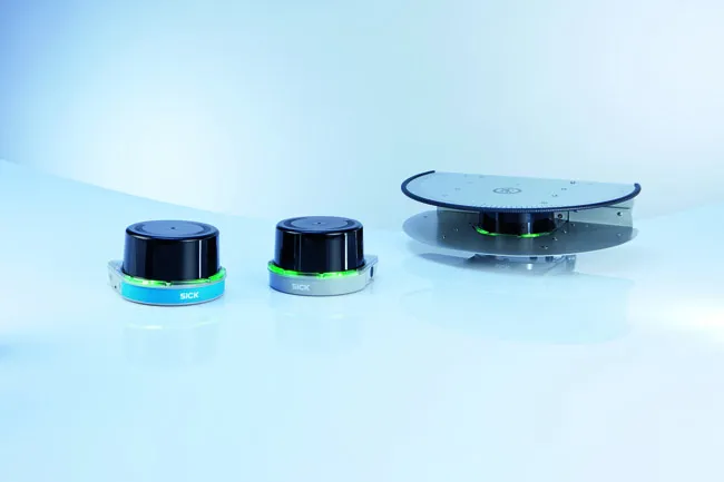
SICK’s MRS1000 scans in four planes at different heights
SICK says that it’s recently launched LMS1000 and MRS1000 infrared LiDAR sensors deliver more accurate and reliable distance sensing and measurement, especially in difficult conditions.


The robust, compact sensors weigh just 1.2kg and come with rotatable connectors for easy mounting on gantries. Heavy rain, mist, dust or snow can lead to false signals, explained Neil Sandhu, 3316 SICK’s national product manager for imaging, measurement, ranging and systems. The addition of SICK’s triple-echo HDDM+ - High Definition Distance Measurement - scanning to the SICK LMS and MRS allows much greater consistency in performance even when the sensors face adverse environmental conditions.

“MRS1000’s four plane detection capability enables it to be used for more complex tasks as diverse as buildings, transport park and boundary management, and security for large or sensitive areas,” said Sandhu.

The SICK LMS1000 scans in a single plane, with a 275o angle of view, up to 64m for a general range of distance detection and ranging applications, with 10 fields allowing several different preprogrammed applications. With the same angle of view and distance, the MRS1000 scans in four planes at different heights, allowing either the height of objects to be scanned in, such as overhanging obstructions or in-depth mapping using the sensor from an elevated position. The 64 fields allow a very wide range of applications.

With exceptionally high scanning frequency, the amount of data collected by the LMS and MRS1000 units ensures very high accuracy for the user. The triple echo evaluation technology means the masking effects of snowfall, mist, rain or dust are eliminated from the signal, giving greater accuracy for the detection and location of rapidly moving objects. A rugged, compact housing resisting shock, impact and vibration also allows an operating temperature range of -30oC to +50oC. Integrated heating ensures that the sensor is fit for duty even in extremes of weather – and keeps maintenance costs low.

Configuration is very easy with SICK’s highly intuitive free SOPAS programming tool. Teaching in the fields takes little time and adds versatility and application-specific performance to the sensor.

The Ethernet interface delivers the measurement data output in real time for immediate operator action where required, and with switching outputs allowing wide availability of the data across an organisation’s local area network.

For more information on companies in this article

Related Content

  • Precision measurements
    February 7, 2012
    Nikon-Trimble is now offering the new Nikon 25mm and 127mm Total Stations, which are said to deliver improved accuracy over previous products.
  • EarthSense Systems releases air pollution map of the UK
    June 15, 2018
    EarthSense Systems has published MappAir, a high-resolution map of air pollution throughout the entire UK. MappAir shows how air pollution - specifically nitrogen dioxide - changes across the country and within towns and cities, highlighting likely sources and potential clean-air refuge areas. It combines data from satellites and its EarthSense Systems’ own air quality monitoring sensors along with open source data. The result, using complex modelling, creates a highly accurate map at 100m resolution, says
  • EarthSense Systems releases air pollution map of the UK
    June 26, 2018
    EarthSense Systems has published MappAir, a high-resolution map of air pollution throughout the entire UK MappAir shows how air pollution - specifically nitrogen dioxide - changes across the country and within towns and cities, highlighting likely sources and potential clean-air refuge areas. It combines data from satellites and its EarthSense Systems’ own air quality monitoring sensors along with open source data. The result, using complex modelling, creates a highly accurate map at 100m resolution, says
  • Using radar to deliver a fine runway finish
    April 4, 2014
    Radar Portal Systems (RPS) has spent a lot of time developing its sophisticated pavement top-surface photometric imaging system so it can cater specifically for the aviation market. This has now been specially developed for use on aircraft runways and taxiways The system was recently used at Brisbane Airport to survey runway and runway shoulders, collecting photometric top-surface data at a 4m width at speeds of up to 100km/h. This dataset allows the firm to display meshing data of the runway surface showin