Exodigo digs deep in Tel Aviv

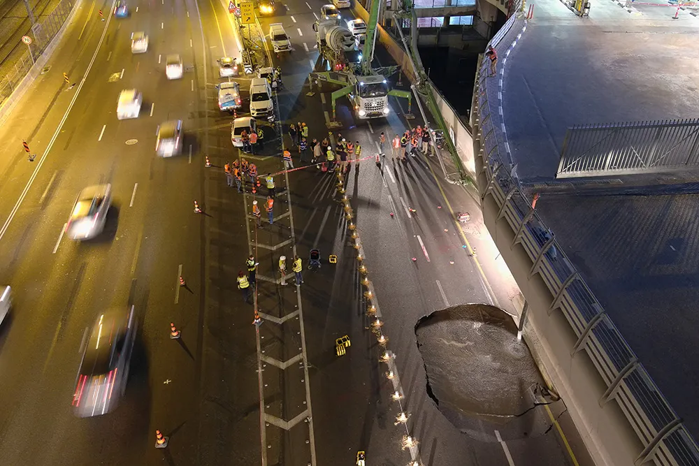
When a large sinkhole opened up on a busy highway in Tel Aviv, Israel, city transport authorities called in the underground mapping experts from Exodigo.
January 31, 2023 Read time: 2 mins
Exodigo uses sensors and cloud-based AI to produce accurate 3D maps of underground areas as deep as 10m (image courtesy Exodigo)

Exodigo’s AI/3D underground mapping tech assessed both current and future risks while the highway was shut down in that area. Exodigo's platform was used not only to assess what could safely open/resume operation, but to provide immediate corrective actions in areas suspected of being unstable to minimise the risk of sinkhole expansion.

The company says that its platform can detect any buried object, from man-made pipes and cables to soil layers, rocks, minerals, and even groundwater. It also works at any scale and terrain, from crowded urban environments to vast rural ones.

Using its advanced, non-intrusive underground mapping AI platform, Exodigo immediately scanned the area with multiple sensor types. The team quickly identified potential risks in surrounding areas on the highway and confirmed the integrity of the areas supporting train infrastructure through its multi-sensing AI platform.

Giving crews the ability to have an accurate, combined CT/MRI/X-ray scan of what is underground can help minimise risks in a wide range of both everyday construction/infrastructure activities and potentially fatal situations such as sinkholes.

According to Exodigo, no other technologies properly “see” underground. Meanwhile, the company’s technology rapidly creates digital, 3D geographic maps of the underground – utilities, pipes and cables, as well as details on soil layers, rocks, minerals and groundwater.

For more information on companies in this article

Related Content

  • Eradicating work zone danger
    June 26, 2013
    New safety systems for highway work zones are helping to reduce deaths and injuries in the United States, while much work is being done in Europe to improve work zone safety. Guy Woodford reports. With more road building underway than at any one time in Texas history, the US Lone Star state’s Department of Transportation (TxDOT) is introducing its first highway safety system with queue-warning technology and temporary rumble strips to cut work zone collisions. Debuting along a central Texas stretch of the
  • Ground penetrating radar used to investigate tunnel deterioration
    May 13, 2015
    Using ground penetrating radar to determine reason for serious pavement settling in Kentucky-Tennessee tunnel Just a few years after the opening of the Cumberland Gap Tunnel, highway officials noticed moderate to severe settling of the continuously reinforced concrete pavement. The mountain tunnel provides an important link between Kentucky and Tennessee along US25E and the problem looked serious, with many voids discovered beneath the pavement surface. To investigate the problems, the Kentucky Transpor
  • Vitronic at German test track
    January 7, 2022
    Vitronic has installed sensor technology along a designated Test Track for Automated and Connected Driving – TAVF – on a public road in Hamburg, Germany. This test installation aims to contribute to optimising traffic flow and increasing road safety, particularly vulnerable road users such as pedestrians and cyclists, on a busy road about 2km from the main railway station.
  • Highways: environmental problem or environmental enhancement?
    March 21, 2016
    Highways need not be a blight on the countryside that many people, urban planners included, believe they will always be. By Bram Miller, director, and Martin Broderick, environmental consultant, at Ramboll Environ While the world’s highway networks bring undoubted economic and social benefits, they are generally perceived to lead to negative environmental impacts. Some may consider this an unfair reputation, but it is difficult to argue that in the majority of cases both the construction and operation of