Exodigo digs deep in Tel Aviv

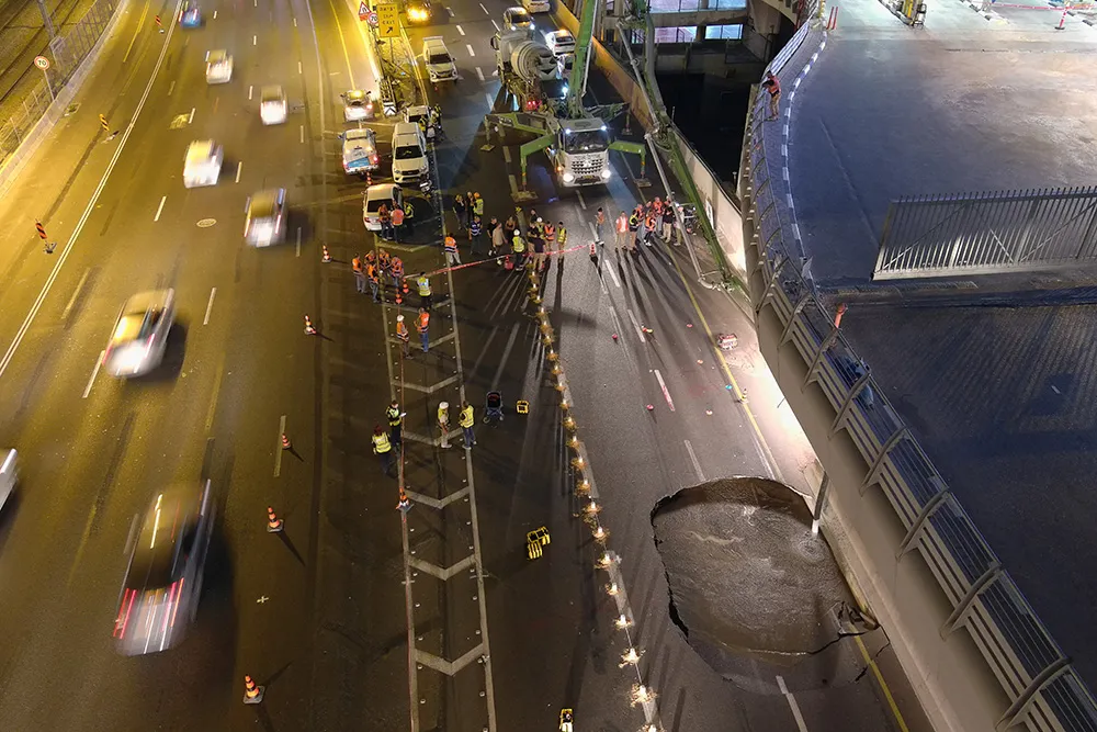
When a large sinkhole opened up on a busy highway in Tel Aviv, Israel, city transport authorities called in the underground mapping experts from Exodigo.
January 31, 2023 Read time: 2 mins
Exodigo uses sensors and cloud-based AI to produce accurate 3D maps of underground areas as deep as 10m (image courtesy Exodigo)

Exodigo’s AI/3D underground mapping tech assessed both current and future risks while the highway was shut down in that area. Exodigo's platform was used not only to assess what could safely open/resume operation, but to provide immediate corrective actions in areas suspected of being unstable to minimise the risk of sinkhole expansion.

The company says that its platform can detect any buried object, from man-made pipes and cables to soil layers, rocks, minerals, and even groundwater. It also works at any scale and terrain, from crowded urban environments to vast rural ones.

Using its advanced, non-intrusive underground mapping AI platform, Exodigo immediately scanned the area with multiple sensor types. The team quickly identified potential risks in surrounding areas on the highway and confirmed the integrity of the areas supporting train infrastructure through its multi-sensing AI platform.

Giving crews the ability to have an accurate, combined CT/MRI/X-ray scan of what is underground can help minimise risks in a wide range of both everyday construction/infrastructure activities and potentially fatal situations such as sinkholes.

According to Exodigo, no other technologies properly “see” underground. Meanwhile, the company’s technology rapidly creates digital, 3D geographic maps of the underground – utilities, pipes and cables, as well as details on soil layers, rocks, minerals and groundwater.

For more information on companies in this article

Related Content

  • Accurate utilities detection
    November 26, 2024

    Trimble and Radiodetection are collaborating to improve the technology used in the utility measurement and mapping process. Integrating the Trimble Catalyst DA2 GNSS system and Radiodetection’s RD MapTM+ application and precision locator products helps to streamline utility-locating workflows to provide accurate measurement capabilities and generate underground utilities maps in a single field operation.

  • Road and runway repair success
    July 2, 2012
    Fugro Aperio says it is improving the quality of road and airport runway repair techniques using its sophisticated ground penetrating radar (GPR) technology. The firm is now able to offer a combination of real time kinematic (RTK) GPS with multi channel radar systems due to partnerships with Yotta in the UK, and Pavement Management Services in Australia and the Middle East. This sophisticated package enables pre-planning of surveys, quicker execution and better positioning for more precise mapping of defect
  • Safety measures aid workzone accident reduction
    February 20, 2012
    Everyone connected with the highway industry is involved in the efforts to cut down the number of work zone accidents. Patrick Smith reports. A few months ago, as road work resumed on America's highways and bridges, US Transportation Secretary Ray LaHood called on drivers to use extra caution in work zones. At the same time he commended the success in reducing overall roadway fatalities in each of the last seven years.
  • Advances in tunneling technology offer efficiency
    October 18, 2017
    New developments in tunnelling technologies offer contractors greater efficiencies when constructing new bores. Tunnel boring machines (TBMs) are widely being used in major projects such as the Brenner Base Tunnel in the Austrian Alps. Full face TBMs are highly sophisticated machines featuring a rotating drilling head, which removes the material, and, depending on the type of construction, secures the excavated tunnel with shotcrete, rock bolts and wire mesh or prefabricated segments of reinforced concrete.