Esri and Heliguy to cooperate

Esri UK has signed a partnership with drone developer Heliguy as part of its strategy to offer all elements of a drone service.
February 15, 2021 Read time: 2 mins
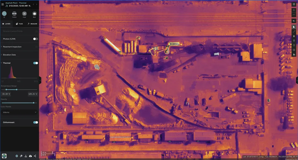
Thermal imaging using Esri UK Site Scan

The partnership will provide customers with drone hardware, pilot training and flying services from Heliguy, adding to Esri’s existing drone flight planning, data capture, data processing and GIS software.

Current Esri drone software customers include Skanska Norway, Arcadis and PCL Construction in North America. Meanwhile, Heliguy, an unmanned aerial vehicle specialist, manages some of Europe’s largest drone programmes, working with construction firms such as Balfour Beatty and Atkins.

Esri UK and Heliguy will work on joint projects to introduce new and more efficient workflows by bringing together customers’ GIS and Survey teams who have traditionally worked separately on drone-related projects. The goal is to streamline processes, from drone management and data capture, through to data analysis and better sharing of outputs across a business, including integration with BIM and CAD workflows.

“By providing a single source of hardware and software, the partnership will help customers maximise their investment in drones and GIS,” said Craig Evenden, head of construction and BIM at Esri UK. “As drone usage grows, accelerated by the COVID-19 pandemic, the [construction] community is demanding more integrated programmes that can easily grow across their business. Heliguy’s vast experience and training capabilities, coupled with Esri’s cloud-based drone and GIS software are a perfect match for the AEC industry’s new enterprise requirements.”

Esri UK customers include Arcadis, Mott MacDonald, Costain, Crossrail, the Skanska, Costain and STRABAG Joint Venture and Highways England. Formed in 2006, Heliguy is based in the UK with an office in Dallas in the US state of Texas.

For more information on companies in this article

Related Content

  • Precision narrows the gap between design software and GIS
    March 20, 2012
    Greater precision is helping blur the boundaries between GIS technology and design software While GIS map based technology has extended its range across an ever more universal spectrum of uses in the highways sector, it is increasingly showing weaknesses for engineering purposes. It is very often not accurate enough. This has not mattered previously because the GIS tool has been seen essentially as an automated version of paper based systems from the design department's point of view. Where engineers
  • Topcon and Bentley training event
    April 12, 2018
    Topcon Positioning Group and Bentley Systems has run the first in its collaborative Constructioneering Academy initiatives The first session was held recently in Livermore, California. The two firms have joined efforts to provide opportunities designed to allow construction industry professionals to learn best practices in constructioneering, a process of managing and integrating survey, engineering, and construction data, to streamline construction workflows and improve project delivery. This approach
  • Quantm is making Trimble one of the world’s leading BIM market challengers
    December 19, 2016
    When Trimble first launched its Quantm software system a decade or so ago, the company was making an important step into end-to-end BIM modelling. The rules of the game were changing fast. Adrian Greeman reports When survey and machine control equipment maker Trimble bought the Australian road planning software system Quantm in 2006 it might not have realised quite what it was leading to. A decade later, Quantm is helping to put Trimble among the big players in the BIM (building information modelling) en
  • UK’s A14 route to open early
    February 11, 2020
    Highways England has announced that the UK’s A14 route is to open early.