CityStream goes on stream for US authorities

Nexar’s CityStream platform allows road agencies to see the layout of work zones any time.
By David Arminas September 1, 2021 Read time: 2 mins
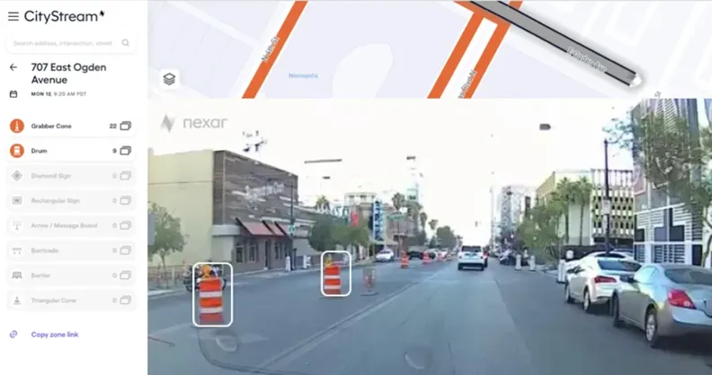
Nexar’s CityStream licence allows users to know how many work zones there are at any given time (image courtesy Nexar)

Nexar is to provide free for a limited time to US transit agencies a service that detects, monitors and maps road work zones.

Nexar, based in New York City, produces dash cams and platforms for vehicle-to-vehicle networks that help prevent collisions. To do so, Nexar’s dash cams within the vehicles of drivers using the company’s services collect data every month across around 210 million kilometres (130 million miles) of roads. The company says it has a dataset of 3.2 trillion images, including real-time images of work zones.

The company’s said it is offering its CityStream service free for three months to road agencies and transportation departments because it believes that work zones are generally unreported to mapping services. Nexar said all its images are accurately located for context and time before being sent to city officials.

“As a result of Covid-19, traffic patterns have become even more dynamic, which means valuable time is wasted optimising safety and moderating traffic congestion in work zones,” said Eran Shir, co-founder of Nexar.

Shir said that Nexar enables cities to go back in time and check work zone setups whenever they wish instead of having to use old data or out-of-date plans because work zone areas have changed. This ensures cities and transportation departments are addressing transportation patterns on a real-time basis.

The issue is particularly important because US government plans to rebuild infrastructure, including fixing 320,000km (20,000 miles) of roads and 10,000 bridges, are expected to create a sharp increase in new work zones. This will cause traffic congestion and safety challenges.

More information and how to apply for a licence is available on Nexar’s website by clicking here.

For more information on companies in this article

Related Content

  • Solari gives Doha airport baggage truck drivers the VMS signal
    March 6, 2015
    VMS innovations offer transportation efficiency gains – David Arminas writes. Baggage truck drivers at the new Hamad International Airport in Doha, Qatar, are now getting real-time imformation and directions on variable message signage. The airport opened last April and will be the first touchdown point for fans attending the football World Cup in Qatar in 2022. The airport is only 4km away from the overused but now redundant Doha International Airport, which will be demolished and redeveloped as an urban p
  • Using ITS to maximise safety and traffic flow for cycling
    January 22, 2013
    Copenhagen, Denmark, has long been known as one of the world’s leading cities for cycling. In some areas of the city, the modal share of bikes has reached a level of as much as 50 %. And on some of the most frequently used bike paths the average daily number of cyclists is close to 30,000. As these numbers continue to rise, new ways of planning and implementing cycling infrastructure are needed. Increasingly, Danish traffic planners are turning to technology as a tool for planning cycling infrastructure. I
  • Financial close for Louisiana’s Calcasieu Bridge
    August 19, 2024
    Sacyr said that the project is the company’s first transportation infrastructure private-public partnership contract in the US and calls for a total of $2.27 billion in construction investment.
  • StreetLight Data picks up Minnesota traffic planning contract
    December 14, 2017
    StreetLight Data, a US mobility analytics company, has been selected by the Minnesota Department of Transportation (MnDOT) for a state-wide project.