
Biral showcases meteorological equipment at UK highways show

Meteorological specialist Biral recently exhibited its range of advanced weather and visibility sensors at the Highways Management Show in Coventry, UK Biral, set up in 1975, works with companies and organisations across all industries, including road and transportation, to deliver solutions to monitor visibility and local weather conditions as part of smart road systems and intelligent transport networks. Biral said that its VPF and SWS Visibility and Present Weather Sensors ranges are particularly benefic
January 6, 2017 Read time: 3 mins

Meteorological specialist Biral recently exhibited its range of advanced weather and visibility sensors at the Highways Management Show in Coventry, UK

8558 Biral, set up in 1975, works with companies and organisations across all industries, including road and transportation, to deliver solutions to monitor visibility and local weather conditions as part of smart road systems and intelligent transport networks. Biral said that its VPF and SWS Visibility and Present Weather Sensors ranges are particularly beneficial to highways applications due to their highly reliable and accurate readings. These sensors can be used to warn motorists of roadside fog, limited tunnel visibility, bridge conditions and general meteorological issues. The correct precautionary information can then be given to road users, such as adjusting carriageway speed limits and issuing fog and reduced visibility warnings.

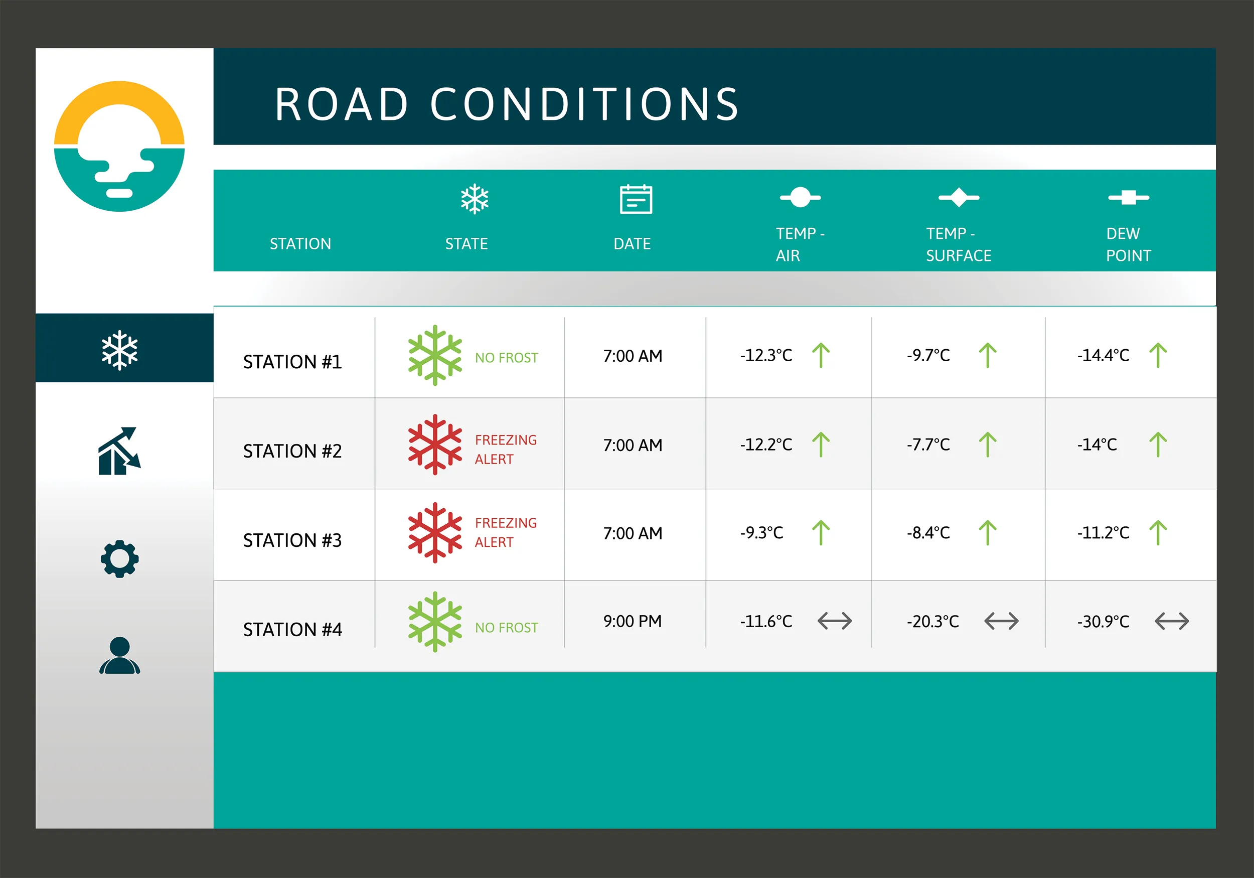
Biral noted that its SWS range is especially well suited to highways applications as its combination of serial and analogue interfaces can assist with local signage control and can be directly connected to a wider network. The sensors are also used indirectly, to monitor pollution levels in tunnels and control the ventilation systems.

They can also act as secondary fire detectors in tunnels due to their sensitivity to smoke particles. The VPF and SWS ranges have been used for an extensive range of applications, some exceeding 20 years, which proves the reliable performance and durability of the equipment. The company also exhibited a range of products from German manufacturer Adolf Thies, for which Biral is the exclusive UK distributor. This range includes meteorological sensors for relative humidity, temperature, air pressure, radiation, wind speed and direction and precipitation. Biral said that its own products sit alongside those of Thies to offer the complete range of meteorological measurements required by local, national and governmental level authorities across the UK transport network. To this end, Biral is developing a Road Weather Information System (RWIS) to be launched next year. The system will combine all of the key meteorological measurements into one compact, reliable and easy to install and use system.

Biral has also developed equipment with the ability to accurately monitor the movement of lightning. The company said that its BTD-300 Thunderstorm Detection system can detect a lightning strike to a range of 83km. The stand-alone unit warns of approaching thunderstorms and reports back to the control centre, giving operators enough time to safely shut down or postpone operations until the system has detected the strike to have safely passed.

For more information on companies in this article

Related Content

  • Campbell Scientific launches smarter weather station, Weatherbrain
    February 9, 2018
    Campbell Scientific Canada has launched its WeatherBrain meteorological system for highways after a year of testing in the city of Magog, Canada. WeatherBrain is a software package that produces readable meteorological data for predicting road and weather conditions, allowing more efficient use of road crews.
  • EarthSense Systems releases air pollution map of the UK
    June 15, 2018
    EarthSense Systems has published MappAir, a high-resolution map of air pollution throughout the entire UK. MappAir shows how air pollution - specifically nitrogen dioxide - changes across the country and within towns and cities, highlighting likely sources and potential clean-air refuge areas. It combines data from satellites and its EarthSense Systems’ own air quality monitoring sensors along with open source data. The result, using complex modelling, creates a highly accurate map at 100m resolution, says
  • EarthSense Systems releases air pollution map of the UK
    June 26, 2018
    EarthSense Systems has published MappAir, a high-resolution map of air pollution throughout the entire UK MappAir shows how air pollution - specifically nitrogen dioxide - changes across the country and within towns and cities, highlighting likely sources and potential clean-air refuge areas. It combines data from satellites and its EarthSense Systems’ own air quality monitoring sensors along with open source data. The result, using complex modelling, creates a highly accurate map at 100m resolution, says
  • Software mapping takes on hard-to-tackle air pollution problems
    June 15, 2018
    Software mapping of air pollution along transport corridors is an important weapon for improving air quality, argues Arne Berndt*. Although power plants and factories play a large part in increasing air pollution globally, traffic is now the largest single contributor. Commercial vehicles account for a significant share of traffic around the world, with freight volumes projected to grow 40% by 2050. Yet, despite modern vehicles being more environmentally friendly than earlier models, the sheer volume of th