SICK’s Free Flow Profiler scans vehicles on the move

SICK has launched the Free Flow Profiler vehicle measurement system that enables highly accurate 3D profiling of vehicles across multiple lanes in free-flow traffic The company says that the Free Flow Profiler is a “versatile and adaptable” all-weather system. It is “ideal for vehicle tolling and classification uses, especially useful in operations such as optimal weight loading of ferries or trains and for verifying vehicle dimensions to maximise revenue recovery”. During multilane, free road movem
August 27, 2019 Read time: 3 mins
SICK’s Free Flow Profiler scans vehicles on the move
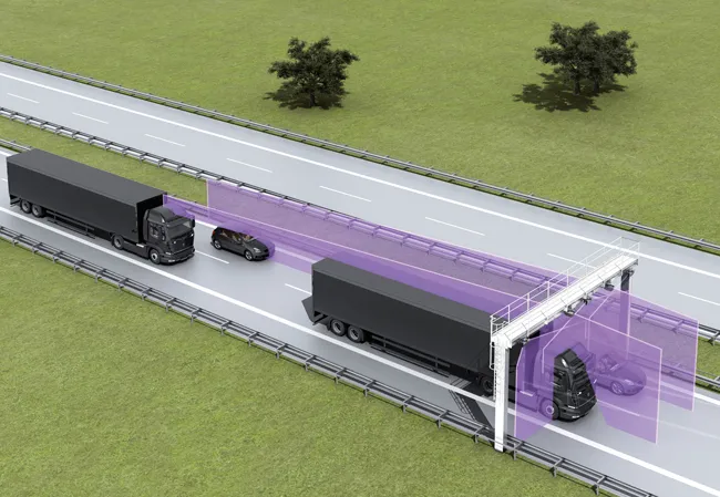
SICK has launched the Free Flow Profiler vehicle measurement system that enables highly accurate 3D profiling of vehicles across multiple lanes in free-flow traffic


The company says that the Free Flow Profiler is a “versatile and adaptable” all-weather system. It is “ideal for vehicle tolling and classification uses, especially useful in operations such as optimal weight loading of ferries or trains and for verifying vehicle dimensions to maximise revenue recovery”.  

During multilane, free road movement, SICK 2D LiDAR sensors are set up to scan traffic at a high frequency and measure vehicle length, width and height automatically. Typically, three SICK sensors will be gantry-mounted. However, the system can be enlarged to encompass multiple lanes or adapted with varying sensor layouts to obtain information for monitoring purposes. The system operates up to 40m to profile all vehicle types, from heavy road transport to passenger cars, towed vehicles and motorcycles.

Vehicle measurements are processed in the SICK Traffic Controller to produce a highly-accurate 3D model of each vehicle. The system captures vehicle dimensions, vehicle type, driving direction and lane assignment. Options to integrate vehicle classification, axle counting or detection of overheated vehicle parts can be added to meet local operator conditions and requirements.

The SICK Free Flow Profiler system can be incorporated into new facilities, retrofitted and even easily relocated. Capable of accurately profiling vehicles at speeds from 0-120kph, it can be integrated with other traffic management monitoring systems such as optical character recognition, CCTV and security.

Gantry-mounted, or direct-mounted on existing structures over traffic lanes, installation is non-disruptive without disturbance of the road surface. The IP67 protected SICK LMS511 Class 1 (eye-safe) LiDAR sensors have an operating temperature range of -30°C to +60°C.

The Free Flow Profiler software provides operators with easy access to the collected and processed data. Easy to commission with an installation wizard and simple to operate, data can be accessed via a standard web browser and downloaded via the TCP/IP interface to the customer traffic management control. History of the last 50 vehicles is displayed automatically.

“It offers a versatile solution whenever accurate 3D vehicle profile is an advantage,” says Neil Sandhu, SICK’s UK product manager for imaging, measurement and ranging. “For example, warnings of over height or over-sized vehicles, approaching bridges or tunnels or loading ferries so that the distribution of vehicles and weights is optimised. Up to 30 different automated vehicle classifications enable precise charging of toll fees.”

Related Content

  • Traffic Data Systems introduces its WIM-DSP 32 system for use with Kistler Lineas sensors
    September 15, 2015
    Traffic Data System has introduced its WIM-DSP 32 system - digital signal processing – specifically for use with Kistler Lineas sensors and Kistler charge amplifiers. The design WIM-DSP 32 system has an integral colour graphics display and touch keys for easy configuration and functional control . WIM-DSP 32 enables a broad range of applications, from simple WIM systems for statistical purposes to sophisticated Weigh in Motion Enforcement -- WIM-E -- systems with monitoring and control of lane changes.
  • Sophisticated GNSS system
    February 9, 2012
    Leica Geosystems says that its new GR10 unit is a sophisticated GNSS reference station receiver and features ease of use, reliability and performance. The GR10 is said to help streamline system installation, day to day operation and administration. The system can be commissioned quickly and features its own receiver hostname while DHCP support means there is no need for pre-configuration of the IP address.
  • Accurate data capture with Hexagon
    January 2, 2022
    Hexagon is introducing the Leica BLK ARC and the Leica BLK2FLY tools, which offer speed, portability and mobility for autonomous mobile reality capture.
  • Aggregate Industries launches Automated Inspection and Testing
    May 15, 2018
    With safety the priority in road paving, Aggregate Industries says it has launched an automated data gathering system to replace hazardous inspections by crew members. AI says that the new system, known as Automated Inspection and Testing, will see all pavers, rollers and survey vehicles fitted with the latest technology including GPS, infra-red sensors and a data recording unit. All will automatically log high-quality data before, during and after the surfacing process.