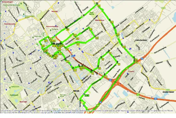
An advanced approach to maintenance is helping ensure that the UK county of Kent keeps on top of road drainage. Kent Highway Services (KHS) has a network of some 8,400km of roads and drains, which requires a fleet of vehicles to maintain and support. In order to keep traffic moving and avoid flooding hazards for motorists, road drainage systems have to be consistently monitored and maintained. Previously this was carried out on a reactive basis, but this has proved to be neither cost effective nor efficient
An advanced approach to maintenance is helping ensure that the UK county of Kent keeps on top of road drainage. Kent Highway Services (KHS) has a network of some 8,400km of roads and drains, which requires a fleet of vehicles to maintain and support. In order to keep traffic moving and avoid flooding hazards for motorists, road drainage systems have to be consistently monitored and maintained. Previously this was carried out on a reactive basis, but this has proved to be neither cost effective nor efficient. To manage this task more effectively KHS needed to capture data about locations and conditions of the drains in order to plan cost effectively for maintenance and repairs.
Using geographic information system technology (GIS),212 esri UK worked with KHS to make this information readily available. Using ESRI UK's ArcPad solution, KHS can now access and record exact locations of drains and conditions and ensure maintenance is carried out without unnecessary costs. The GIS technology allows KHS to calculate efficient routes depending on the location and condition of the drains. This enables efficient maintenance, whilst improving the safety of the highways and reducing vehicle mileage.
ESRI now has a full case study of Kent Highway Services work with the firm and can provide insight into how GIS is becoming a cost effective and vital resource.
Using geographic information system technology (GIS),
ESRI now has a full case study of Kent Highway Services work with the firm and can provide insight into how GIS is becoming a cost effective and vital resource.