Workszone design and planning software

Managing utility works effectively is important, given that digging up roads and then patching them can dramatically cut the life of a road surface. New software tools make this process easier to manage effectively and Bentley Systems is extending its Expert Designer V8i package to include water, gas, and communications infrastructure, in addition to electric utilities. This allows utility firms and engineering contractors using Expert Designer V8i to boost the efficiency of utility network design projects.
March 6, 2012 Read time: 4 mins
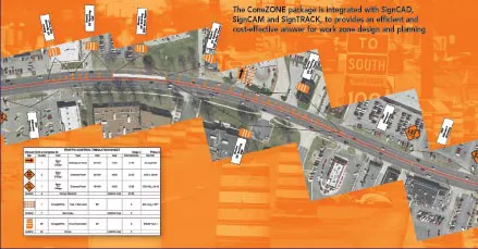
The ConeZONE package is integrated with SignCAD, SignCAM and SignTRACK, to provides an efficient and cost-effective answer for work zone design and planning

Managing utility works effectively is important, given that digging up roads and then patching them can dramatically cut the life of a road surface. New software tools make this process easier to manage effectively and Bentley Systems is extending its Expert Designer V8i package to include water, gas, and communications infrastructure, in addition to electric utilities.

This allows utility firms and engineering contractors using Expert Designer V8i to boost the efficiency of utility network design projects. The new package includes functions for design layout, work-order management, estimating, optimisation, structural analysis, job close-out, process measurement and a detailed audit trail.

Meanwhile 2606 Mayrise Systems says that its new PDA-based system helps monitor street works. This latest development offers access to the firm's Street Works Management software from a hand-held device. The unit is said to reduce administration and increase efficiency by giving street works inspectors a link to back office information, while on-site. The hand held devices can access work schedules, update inspection checklists and display the street works register (SWR), as well as providing street-level maps to speed site identification. Mobile communications enable the devices to communicate with street works registers, giving inspectors on-site access to works records.

A new Information Manager dashboard tool from 2603 Exor can provide performance indicators and management information about Utility Assets. This package gives executives access to high level data through the Internet and can help gather and present data for works promoters and street authorities. The system works as a search engine for enquiries or street works on the highway and a user can query and display works due to take place during a specific date range on a given street. The firm says that its Information Manager package boosts efficiency by helping works promoters and street authorities manage and present data in an accessible format.

Meanwhile the new Mobile Street Works package can also be integrated with 2794 Microsoft Office and appointments scheduled in the field are synchronised with the inspector's Outlook calendar. The MapNow mapping solution can help identify and locate works on maps, with optional GPS positioning it can provide a precise check on site locations.

3688 MVA Consultancy, in partnership with Dumfries and Galloway Council and 3690 Strathclyde Partnership for Transport (SPT), has developed a GIS application to examine and categorise the quality of public transport and highway infrastructure, as well as identify hazards. The on-site results are downloaded to a database with a GIS application and this allows locations to be prioritised so that highway works can be undertaken. The PUDO GIS/PDA System has already been used effectively to improve road safety and now forms an integral part of the Scottish Government Road Safety Framework. The partners are investigating further upgrades that will allow public transport and road maintenance managers access to more features.
SignCAD Systems says that its ConeZONE design module offers an economic software solution for designing safe temporary work zones. The package can deliver automated, compliant work zone design and management solutions for all road construction applications.

The ConeZONE package can be used to develop layouts of work zones based on state requirements and provide accurate layouts that comply with US standards for traffic control devices on all streets and highways. Once the user has selected MUTCD work zone type and parameters, it is possible to load a state base map or an aerial photograph of work zone and the program will automatically plot devices and spacing intervals. The software also allows work zone planners to modify for road conditions and safety aspects with dynamic updates, manage stages and phases of multiple projects, track and manage devices in work zones and co-ordinate information among agencies, contractors and engineers.

For more information on companies in this article

Related Content

  • Field use solutions from mixed-reality
    May 22, 2018
    Trimble is now offering its Connect for HoloLens tool as well as a new hard hat solution for Microsoft HoloLens. According to the firm, the new package improves the utility of mixed-reality for practical field applications. “With the rise in acceptance for mixed-reality solutions in business today, the need for 3D visualisation outside the office is driving this next wave of Trimble innovation," said Aviad Almagor, director of Trimble's Mixed-Reality Program. “We are expanding the opportunities for implemen
  • Trimble technology centre stage at CONEXPO-CON/AGG 2014
    March 27, 2014
    The Trimble Quantm alignment planning system, on show at CONEXPO/CON-AGG 2014, allows road designers to cut planning time and deliver projects with little environmental and social impact at a reduced cost. The system analyses millions of alignment alternatives and returns a range of options to the planning team for consideration. When new data becomes available the Quantm system can quickly recalculate more alignment options.
  • ESRI's highway data solution
    March 20, 2012
    ESRI is developing a comprehensive highway data maintenance and linear referencing solution scheduled for release in the fourth quarter of 2010. Aimed at highway departments, state departments of transportation, and national roadway administrations, the company says it will provide an integrated set of tools and functionality that allows agencies to easily maintain highway geometry, their associated multiple linear referencing systems, and complex roadway features
  • ESRI's highway data solution
    February 6, 2012
    ESRI is developing a comprehensive highway data maintenance and linear referencing solution scheduled for release in the fourth quarter of 2010. Aimed at highway departments, state departments of transportation, and national roadway administrations, the company says it will provide an integrated set of tools and functionality that allows agencies to easily maintain highway geometry, their associated multiple linear referencing systems, and complex roadway features.