Smart traffic analysis improvements

Transport and traffic analysis nowadays tends to switch between static analysis modelling for large scale studies and microsimulation for finer grain work, with perhaps the mesoscopic model also finding a place for mid-level. Most producers make software tools at all three levels and increasingly package them together. Spanish firm TSS (Transport Simulation Systems) has gone one better with its latest release Aimsum 7, by giving it the capacity to "zoom in" from a larger scale mesoscopic model to a smaller
June 12, 2012 Read time: 2 mins
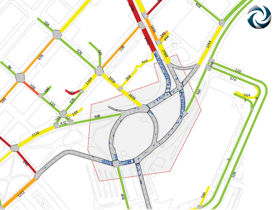
A mesoscopic model of the Aimsun hybrid simulator showing a microscopic pocket of greater detail

Transport and traffic analysis nowadays tends to switch between static analysis modelling for large scale studies and microsimulation for finer grain work, with perhaps the mesoscopic model also finding a place for mid-level. Most producers make software tools at all three levels and increasingly package them together.

Spanish firm TSS (Transport Simulation Systems) has gone one better with its latest release Aimsum 7, by giving it the capacity to "zoom in" from a larger scale mesoscopic model to a smaller area that need microsimulation work, all on the one screen.

It calls the concept the "hybrid simulator" which combines an event-based mesoscopic model with a more detailed time-sliced microsimulation.

This marks a sea change in how traffic models will be conceived, the firm claims, declaring that the method means models will not simply be built once and then discarded. "The hybrid makes it possible for the first time to build demand models on a larger and larger scale using a single all-in-one package,” claimed TSS managing director Jaime Ferrer “with no cumbersome manual interfacing between macroscopic and microscopic models and no need to be updating and revising separate models with independent networks and databases."

154 Aimsun 7 also includes a new network revisions feature, which allows a change made in the base network model to apply automatically to all related future scenarios.

Another new feature is the FZP exporter, which exports simulations to 685 Autodesk 3Ds Max for high–quality 3D presentations. OpenStreetsMap importer allows import of geometry from anywhere via the internet.

For more information on companies in this article

Related Content

  • Thinking ahead in construction: digital PERI solutions for every project phase
    November 1, 2021
    One step ahead in the digital construction world with PERI
  • New Bocimi Toll Road Aims to Reduce Travel Time and Boost Indonesia’s Economy
    April 20, 2023
    The Bogor-Ciawi-Sukabumi (Bocimi) toll road is a series of national strategic projects to help reduce traffic congestion along the existing factory-lined roadway, as well as enhance regional connectivity and tourism in West Java. Spanning 54 kilometers, the new highway corridor is expected to shorten travel time between the Bogor and Sukabumi provinces from two hours to 30 minutes and boost economic conditions in the surrounding Sukabumi area. Construction is divided into four phases, the first of which measures 15.35 kilometers and is already complete. PT Waskita Karya (Waskita) is the main contractor for the IDR 2.1 trillion second section, spanning 11.9 kilometers between Cigombong and Cibadak, and set for completion in 2023 after being delayed due to the pandemic.
  • Highways UK event highlights the time for change for Highways England
    November 13, 2015
    The planning of strategic highways in England is locked into a two-tier mentality that is not good for the economy or for society. It is time to change. That is the message that David Quarmby, former chair of the RAC Foundation and head of RJRF’s Major Roads for the Future study, will be bringing to Highways UK, the landmark new roads conference at ExCel, London, 25th-26th November. In his keynote address Quarmby will argue that while welcome new funds, a new planning regime and a new arm’s length ro
  • Ontario opts for Power InRoads design tools
    June 12, 2012
    One of Canada's largest provinces, Ontario, has decided to go with the latest Power InRoads suite of design tools now being offered by Bentley Systems as a complete stand-alone version As well as the Inroads tools, that means Ontario's Ministry of Transportation will use drafting and document production by the MicroStation CAD tool, and mapping and GIS functionality from Bentley Map. It previously used InRoads for highways work but on an AutoCAD platform. The whole new package is also designed to work co