Smart traffic analysis improvements

Transport and traffic analysis nowadays tends to switch between static analysis modelling for large scale studies and microsimulation for finer grain work, with perhaps the mesoscopic model also finding a place for mid-level. Most producers make software tools at all three levels and increasingly package them together. Spanish firm TSS (Transport Simulation Systems) has gone one better with its latest release Aimsum 7, by giving it the capacity to "zoom in" from a larger scale mesoscopic model to a smaller
June 12, 2012 Read time: 2 mins
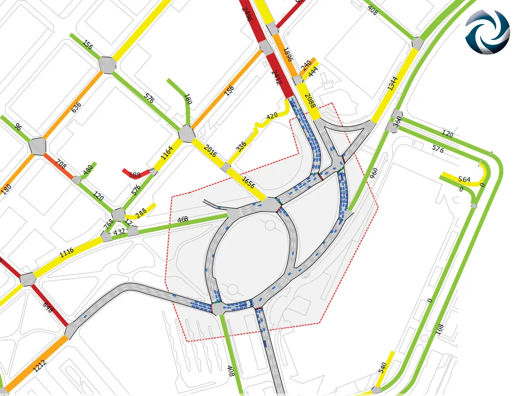
A mesoscopic model of the Aimsun hybrid simulator showing a microscopic pocket of greater detail

Transport and traffic analysis nowadays tends to switch between static analysis modelling for large scale studies and microsimulation for finer grain work, with perhaps the mesoscopic model also finding a place for mid-level. Most producers make software tools at all three levels and increasingly package them together.

Spanish firm TSS (Transport Simulation Systems) has gone one better with its latest release Aimsum 7, by giving it the capacity to "zoom in" from a larger scale mesoscopic model to a smaller area that need microsimulation work, all on the one screen.

It calls the concept the "hybrid simulator" which combines an event-based mesoscopic model with a more detailed time-sliced microsimulation.

This marks a sea change in how traffic models will be conceived, the firm claims, declaring that the method means models will not simply be built once and then discarded. "The hybrid makes it possible for the first time to build demand models on a larger and larger scale using a single all-in-one package,” claimed TSS managing director Jaime Ferrer “with no cumbersome manual interfacing between macroscopic and microscopic models and no need to be updating and revising separate models with independent networks and databases."

154 Aimsun 7 also includes a new network revisions feature, which allows a change made in the base network model to apply automatically to all related future scenarios.

Another new feature is the FZP exporter, which exports simulations to 685 Autodesk 3Ds Max for high–quality 3D presentations. OpenStreetsMap importer allows import of geometry from anywhere via the internet.

For more information on companies in this article

Related Content

  • Software innovations
    June 22, 2012
    New developments in the software sector will improve construction efficiency. Standards organisation BSI is working with government, industry bodies, and private construction practices to create best practice standards for implementing Building Information Modelling (BIM). In 2011 the UK Government announced that all suppliers that wish to bid for public sector construction contracts must use BIM tools and techniques from 2016, making its implementation commercially critical for companies that wish to apply
  • Laser scanning focuses on asset management
    January 9, 2015
    Laser scanners and improved data collection and analysis software are making light of asset management surveying. David Arminas reports The age of the laser scanner is upon us, taking over from traditional manual methods of surveying, data collection and processing. These new technical developments are making it much easier to process and use the data captured and are providing highways engineers with powerful tools to record, map and visualise their assets. This is good news for highways authorities
  • Software innovations boosting construction efficiency
    February 6, 2017
    Software innovations can help road construction and asset management – Mike Woof writes New developments in construction software offer major benefits for civil engineers, contractors and maintenance firms. The latest advances will help optimise the construction process, while also allowing easier monitoring of existing assets. In terms of construction, Bentley Systems is again pushing the bar with regard to advanced software solutions. Its latest OpenRoads ConceptStation package is said to combine en
  • Data handling for efficient machine control
    October 16, 2012
    The rapid increase in information availability is transforming the construction sector. Conventional methods used for sourcing geographic data based on maps and localised sampling meant that there was often a lack of accurate information relating to ground conditions at specific areas where work was planned, often resulting in unwelcome surprises for construction companies along with additional costs for projects.