Smart traffic analysis improvements

Transport and traffic analysis nowadays tends to switch between static analysis modelling for large scale studies and microsimulation for finer grain work, with perhaps the mesoscopic model also finding a place for mid-level. Most producers make software tools at all three levels and increasingly package them together. Spanish firm TSS (Transport Simulation Systems) has gone one better with its latest release Aimsum 7, by giving it the capacity to "zoom in" from a larger scale mesoscopic model to a smaller
June 12, 2012 Read time: 2 mins
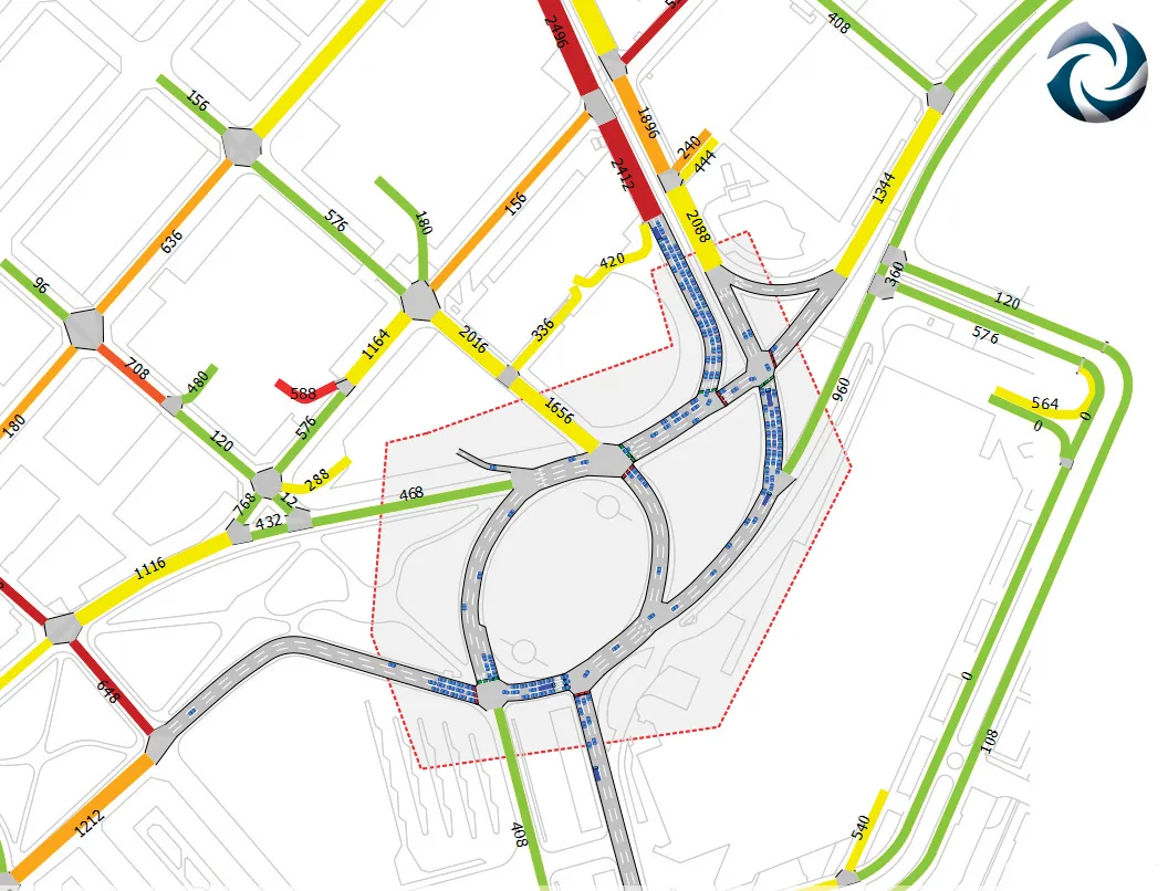
A mesoscopic model of the Aimsun hybrid simulator showing a microscopic pocket of greater detail

Transport and traffic analysis nowadays tends to switch between static analysis modelling for large scale studies and microsimulation for finer grain work, with perhaps the mesoscopic model also finding a place for mid-level. Most producers make software tools at all three levels and increasingly package them together.

Spanish firm TSS (Transport Simulation Systems) has gone one better with its latest release Aimsum 7, by giving it the capacity to "zoom in" from a larger scale mesoscopic model to a smaller area that need microsimulation work, all on the one screen.

It calls the concept the "hybrid simulator" which combines an event-based mesoscopic model with a more detailed time-sliced microsimulation.

This marks a sea change in how traffic models will be conceived, the firm claims, declaring that the method means models will not simply be built once and then discarded. "The hybrid makes it possible for the first time to build demand models on a larger and larger scale using a single all-in-one package,” claimed TSS managing director Jaime Ferrer “with no cumbersome manual interfacing between macroscopic and microscopic models and no need to be updating and revising separate models with independent networks and databases."

154 Aimsun 7 also includes a new network revisions feature, which allows a change made in the base network model to apply automatically to all related future scenarios.

Another new feature is the FZP exporter, which exports simulations to 685 Autodesk 3Ds Max for high–quality 3D presentations. OpenStreetsMap importer allows import of geometry from anywhere via the internet.

For more information on companies in this article

Related Content

  • Wirtgen’s new recycling technology
    June 22, 2018
    Wirtgen is offering an array of new technologies for milling, recycling and stabilising applications. These are intended to boost accuracy, versatility and performance. A new milling drum assembly is offered that widens the range of applications that the Wirtgen W 150 CF/W 150 Cfi milling machines can handle. This redesigned assembly allows users to select an array of cutter drums, including a 1.8m-wide unit. According to the firm, the machines offer the highest power to weight ratio for their class, with d
  • StarTraq software for Fiji traffic offence management
    June 25, 2013
    StarTraq says the implementation of its browser-based road traffic offence processing software has been completed within the Land Transport Authority (LTA) of Fiji. Through the use of StarTraq Dome, the Fijian LTA is said to have installed the required infrastructure to process high volumes of offences promptly, efficiently and at a reduced cost.
  • INRIX redefines Traffic Data Analysis
    October 26, 2016
    INRIX, a global developer of car services and movement analytics, has launched INRIX Roadway Analytics, a set of on-demand tools to be available in Europe and the Middle East this autumn. It enables instant analysis of INRIX XD Traffic information via the cloud. The cost of infrastructure congestion is estimated at 1% of GDP across Europe. At the same time, research suggests that up to US$400 billion could be saved globally each year as a result of improving existing infrastructure through better managem
  • Arizona uses 1Spatial for inventory for the FHWA requirements
    February 6, 2017
    The US state of Arizona is using 1Spatial’s technology to send a yearly update of its entire road network to the Federal Highway Administration. As required by law, all state governments must do this and many have created a data set of their road network. But much of this is held at county level. The challenge, now that data has been collected, is how to keep this information up-to-date and accurate. 1Spatial software will automate the data validation process and also the change process. The technology w