
SICK’s Free Flow Profiler scans vehicles on the move

SICK has launched the Free Flow Profiler vehicle measurement system that enables highly accurate 3D profiling of vehicles across multiple lanes in free-flow traffic
August 27, 2019 Read time: 2 mins
SICK’s Free Flow Profiler scans vehicles on the move

The company says that the Free Flow Profiler is a “versatile and adaptable” all-weather system. It is “ideal for vehicle tolling and classification uses, especially useful in operations such as optimal weight loading of ferries or trains and for verifying vehicle dimensions to maximise revenue recovery”.  

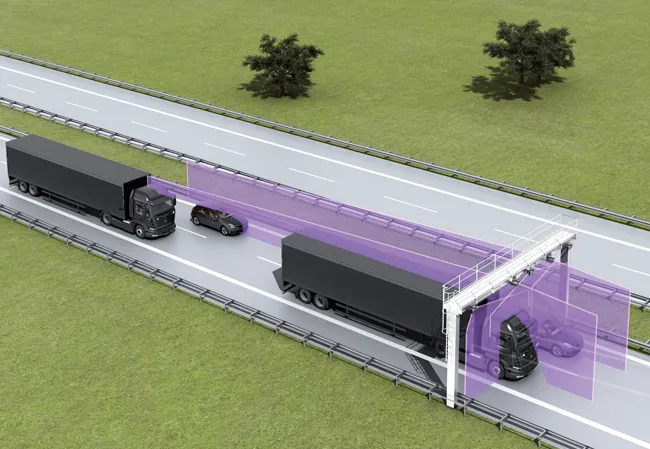
During multilane, free road movement, 3316 SICK 2D LiDAR sensors are set up to scan traffic at a high frequency and measure vehicle length, width and height automatically. Typically, three SICK sensors will be gantry-mounted. However, the system can be enlarged to encompass multiple lanes or adapted with varying sensor layouts to obtain information for monitoring purposes. The system operates up to 40m to profile all vehicle types, from heavy road transport to passenger cars, towed vehicles and motorcycles.

Vehicle measurements are processed in the SICK Traffic Controller to produce a highly-accurate 3D model of each vehicle. The system captures vehicle dimensions, vehicle type, driving direction and lane assignment. Options to integrate vehicle classification, axle counting or detection of overheated vehicle parts can be added to meet local operator conditions and requirements.
 

 SICK 2D LiDAR sensors scan traffic at a high frequency and measure vehicle length, width and height
SICK 2D LiDAR sensors scan traffic at a high frequency and measure vehicle length, width and height

The SICK Free Flow Profiler system can be incorporated into new facilities, retrofitted and even easily relocated. Capable of accurately profiling vehicles at speeds from 0-120kph, it can be integrated with other traffic management monitoring systems such as optical character recognition, CCTV and security.

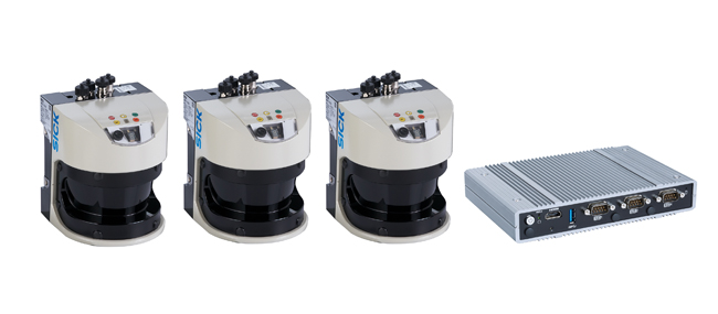
Gantry-mounted, or direct-mounted on existing structures over traffic lanes, installation is non-disruptive without disturbance of the road surface. The IP67 protected SICK LMS511 Class 1 (eye-safe) LiDAR sensors have an operating temperature range of -30°C to +60°C.

The Free Flow Profiler software provides operators with easy access to the collected and processed data. Easy to commission with an installation wizard and simple to operate, data can be accessed via a standard web browser and downloaded via the TCP/IP interface to the customer traffic management control. History of the last 50 vehicles is displayed automatically.

“It offers a versatile solution whenever accurate 3D vehicle profile is an advantage,” says Neil Sandhu, SICK’s UK product manager for imaging, measurement and ranging. “For example, warnings of over height or over-sized vehicles, approaching bridges or tunnels or loading ferries so that the distribution of vehicles and weights is optimised. Up to 30 different automated vehicle classifications enable precise charging of toll fees.”


For more information on companies in this article

Related Content

  • Picture perfect imaging
    June 26, 2012
    Topcon has produced a new imaging station which, it claims, will dramatically increase productivity when used in two-man auto-tracking or single operator robotic modes. Using prism auto-tracking scanning interface technology the IS-3, when used with Topcon’s RC-4 remote control system, will track prisms up to 1,000m away.
  • Latest GIS and software tools improve operations
    February 24, 2012
    Innovative GIS and software solutions are coming to market from the three key market players - Mike Woof reports Competition is strong in the field for GIS and surveying systems as well as the associated software. The three major players in the sector, Leica Geosystems, Topcon and Trimble, all invest heavily in research and development and continue to roll out new solutions for construction customers that will boost the efficiency of surveying as well as overall project implementation.
  • UK companies in traffic-monitoring project in Uganda
    April 11, 2012
    UK consultants, Roughton International, working on behalf of the Uganda National Roads Authority (UNRA), teamed up with Sky High and Traffic Technology to deploy traffic flow data collection equipment suitable for the Ugandan road network.
  • Generate real-world ROI with reality modeling!
    September 8, 2022
    Understanding existing site conditions is essential to efficiently design, build, and operate road networks around the world. But how can the real-world be captured quickly and cost-effectively?