SICK’s Free Flow Profiler scans vehicles on the move

SICK has launched the Free Flow Profiler vehicle measurement system that enables highly accurate 3D profiling of vehicles across multiple lanes in free-flow traffic
August 27, 2019 Read time: 2 mins
SICK’s Free Flow Profiler scans vehicles on the move

The company says that the Free Flow Profiler is a “versatile and adaptable” all-weather system. It is “ideal for vehicle tolling and classification uses, especially useful in operations such as optimal weight loading of ferries or trains and for verifying vehicle dimensions to maximise revenue recovery”.  

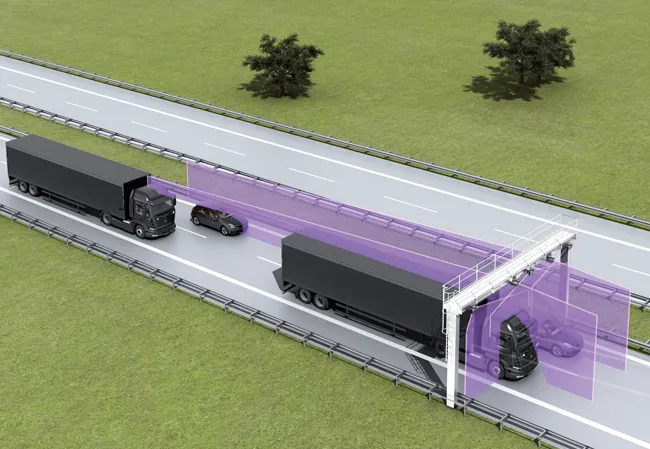
During multilane, free road movement, 3316 SICK 2D LiDAR sensors are set up to scan traffic at a high frequency and measure vehicle length, width and height automatically. Typically, three SICK sensors will be gantry-mounted. However, the system can be enlarged to encompass multiple lanes or adapted with varying sensor layouts to obtain information for monitoring purposes. The system operates up to 40m to profile all vehicle types, from heavy road transport to passenger cars, towed vehicles and motorcycles.

Vehicle measurements are processed in the SICK Traffic Controller to produce a highly-accurate 3D model of each vehicle. The system captures vehicle dimensions, vehicle type, driving direction and lane assignment. Options to integrate vehicle classification, axle counting or detection of overheated vehicle parts can be added to meet local operator conditions and requirements.
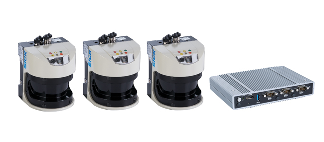
 

 SICK 2D LiDAR sensors scan traffic at a high frequency and measure vehicle length, width and height
SICK 2D LiDAR sensors scan traffic at a high frequency and measure vehicle length, width and height

The SICK Free Flow Profiler system can be incorporated into new facilities, retrofitted and even easily relocated. Capable of accurately profiling vehicles at speeds from 0-120kph, it can be integrated with other traffic management monitoring systems such as optical character recognition, CCTV and security.

Gantry-mounted, or direct-mounted on existing structures over traffic lanes, installation is non-disruptive without disturbance of the road surface. The IP67 protected SICK LMS511 Class 1 (eye-safe) LiDAR sensors have an operating temperature range of -30°C to +60°C.

The Free Flow Profiler software provides operators with easy access to the collected and processed data. Easy to commission with an installation wizard and simple to operate, data can be accessed via a standard web browser and downloaded via the TCP/IP interface to the customer traffic management control. History of the last 50 vehicles is displayed automatically.

“It offers a versatile solution whenever accurate 3D vehicle profile is an advantage,” says Neil Sandhu, SICK’s UK product manager for imaging, measurement and ranging. “For example, warnings of over height or over-sized vehicles, approaching bridges or tunnels or loading ferries so that the distribution of vehicles and weights is optimised. Up to 30 different automated vehicle classifications enable precise charging of toll fees.”


For more information on companies in this article

Related Content

  • Applied Concepts get Latvian approval for Stalker Phoda SE-1
    February 1, 2017
    Stalker Traffic Technologies’ Phodar SE-1 photo traffic enforcement radar system has been approved by Latvia to participate in any Latvian speed enforcement tender. Prior to Latvian acceptance, the SE-1 received its CE Marking and International Organisation of Legal Metrology certification. Both are required for Latvian approval which is granted through the Latvian National Metrology Centre, under the Ministry of Economics. The SE-1 automatically monitors up to 32 vehicles moving in either direction acro
  • Positioning tools continue to improve
    July 16, 2012
    Topcon says that its new IP-S2 package combines GNNS positioning capabilities with inertial sensors, while the firm also has a solution for customers wanting to mix and match receiver components. The IP-S2 is a vehicle-mounted, mobile 3D tool that offers precision mapping and surveying capabilities. The package collects data using 3D laser scanners, LIDAR, and/or cameras, and this is then integrated, time-stamped and geo-referenced. The customer can use this assembled data to combine LIDAR point cloud and d
  • Weigh in motion technology reduces road damage
    February 8, 2012
    Overweight vehicles cause enormous damage to road structures but they can be caught, even at high speed. Weigh-in-motion or WIM devices are designed to capture and record axle weights and gross vehicle weights as vehicles drive over a measurement site.
  • Hamm | Self-monitoring in earthworks via Smart Doc
    April 1, 2021
    With Smart Doc, Hamm presents an app with which compaction in earthworks can be transparently documented and the result shared with third parties. The lean app was developed in close coordination with building practitioners. The focus here was on the possibility of self-monitoring when it comes to compaction in earthworks. Smart Doc also fulfils the minimum requirements of continuous compaction control (CCC). With an intuitive user interface, the app also creates added value when training new roller operators, as all relevant compaction parameters are visualised in real time on the smartphone.