German traffic analysis consultant and software maker PTV, which produces the well-known Visum and Vissim strategic traffic analysis and micro-simulation tools, has launched a new assessment tool aimed at studying traffic impact of new developments.
PTV Vistro is claimed to be the first all-in one-solution for transport analysis and signal optimisation, an easy-to-use software that can be used to conduct traffic studies which are often a mandatory part of development applications and planning approvals.The software uses drag and drop and node templates, to allow users to develop networks quickly. “The software leads the user through the individual steps of a traffic study and also offers him the opportunity to plan and optimise the traffic signals directly within this workflow," says Axel Leonhardt, product management director for the new Vistro program. “Processes that previously required two different tools now require just one solution in this software.”
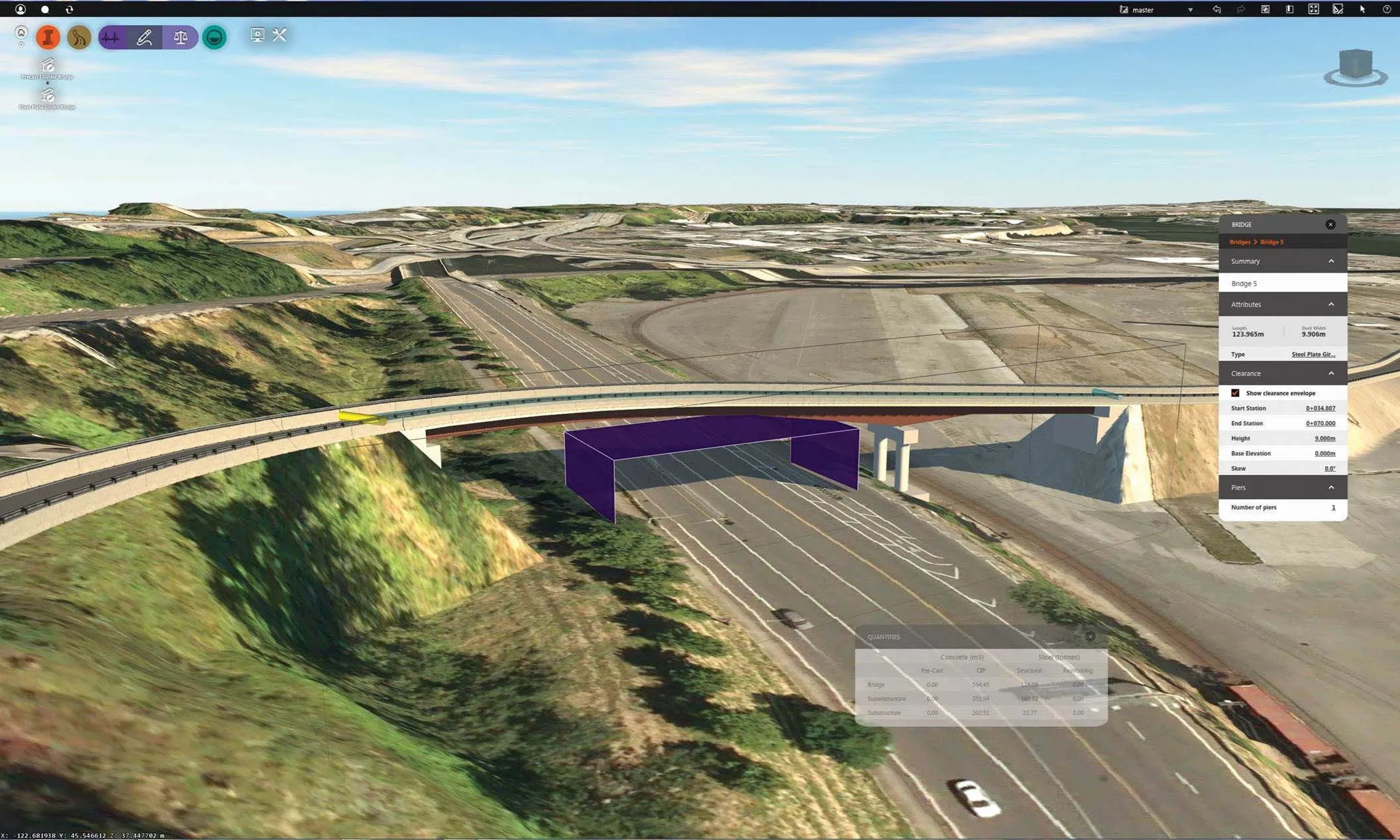
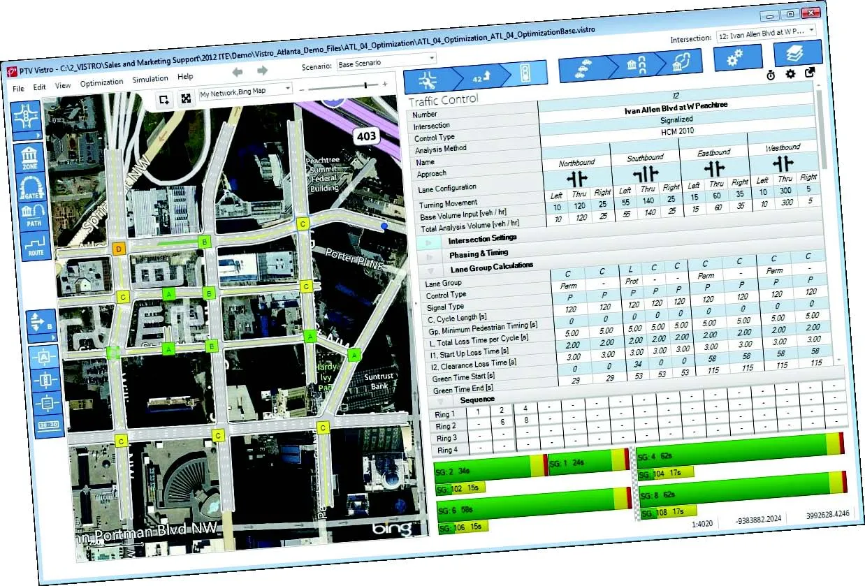
First the user creates his network around the area to be examined. Bing maps and aerials, drag & drop, node templates and "snap-to handles" make modelling easier. Then the user specifies the geometry of the network, adds data from traffic counts and specifies traffic control rules for the individual nodes, such as two-way-stop control or traffic signals.
"Alternatively, existing networks can be imported from our PTV Visum planning software and other planning tools", says Leonhardt.
"Vistro also allows users to create their network model in a highly efficient manner. This makes the software attractive as an additional tool for the Visum or Vissim user," he says.
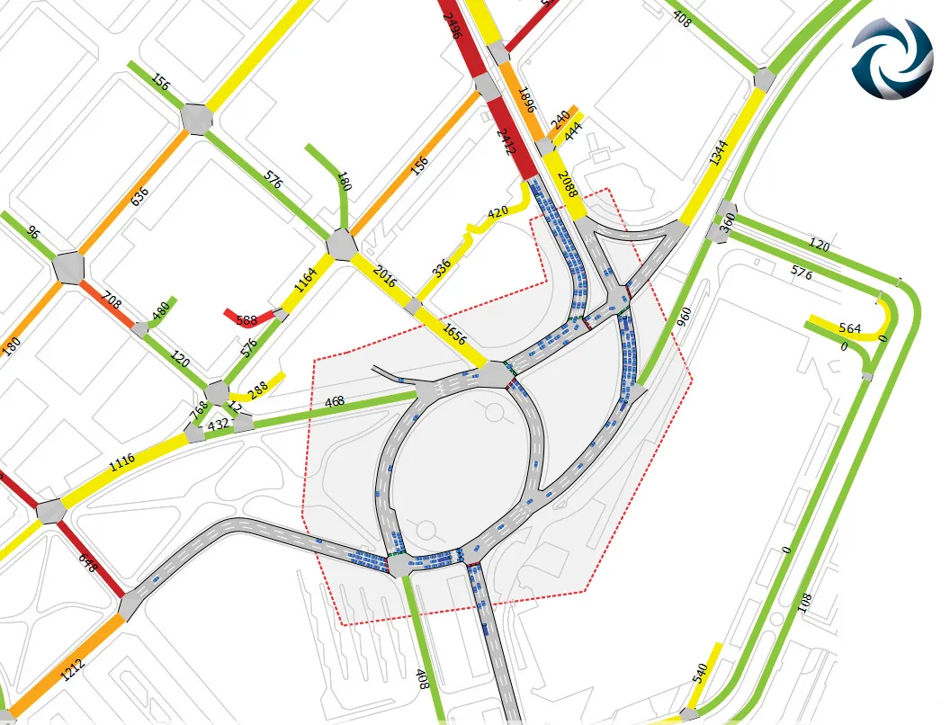
Using base volumes and the volumes induced by new developments, the Level of Service and other indicators are calculated using a selected analysis method, such as the Highway Capacity Manual (HCM) methodology.
"The traffic engineer can use PTV Vistro to optimise the traffic signals at the push of a button – for individual intersections, selected corridors or whole networks," says Leonhardt.
Vistro offers automated reporting for the final version of the traffic impact analyses and signal optimisation. The report is outputted as a PDF file. Data can also go directly into PTV Vissim in order to conduct detailed analyses using microscopic traffic simulation.
Cloud access
Like many software houses the UK's
TRL says the new version will fit with modern technological environments, while offering additional capabilities for the road safety professionals who use it. It also ties with UK Government strategy to expand the use of cloud technologies in the public sector, allowing authorities to free themselves from local IT infrastructures.
TRL says that MAAPcloud has been designed to allow flexible deployment with police forces, local authorities and other road safety stakeholders sharing the system to reduce costs. This may also create opportunities for cross-border and regional collaboration, to further reduce outlays and enabling data sharing.
Authorised users will be able to access powerful analytical tools from any PC, rather than those with desktop software. Data are made available to all members of the relevant road safety partnership, including the latest collision and casualty figures as soon as they are released in the system.
In addition, TRL Software has launched a Russian version of its TRANSYT 14.1 software and TRANSYT Online. Existing TRANSYT 14 customers can obtain it free of charge on request. The package is used by hundreds of consultancies and government organisations around the world designing, modelling and studying individual isolated junctions to large and complex networks to assess individual junction performance and produce optimum fixed-time co-ordinated traffic signal timings.