As the world descended on Vancouver for the 2010 Winter Olympics, visitors were able to travel around the city with confidence and intelligence thanks to a landmark project by IRF Member, Delcan
RSS3100 TransLink, the regional transportation authority for Metro Vancouver, launched the iMove system as a one-stop transportation portal to provide multi-modal, multi-jurisdiction, real-time and static traveller information via the World Wide Web.
The iMove website enables transportation consumers in Metro Vancouver to access information quickly, and from a single source, on a host of transportation issues including transit and cycling routes, construction and event information, current incidents, airline arrivals and departures, border crossing wait times, and ferry sailing times and loadings.
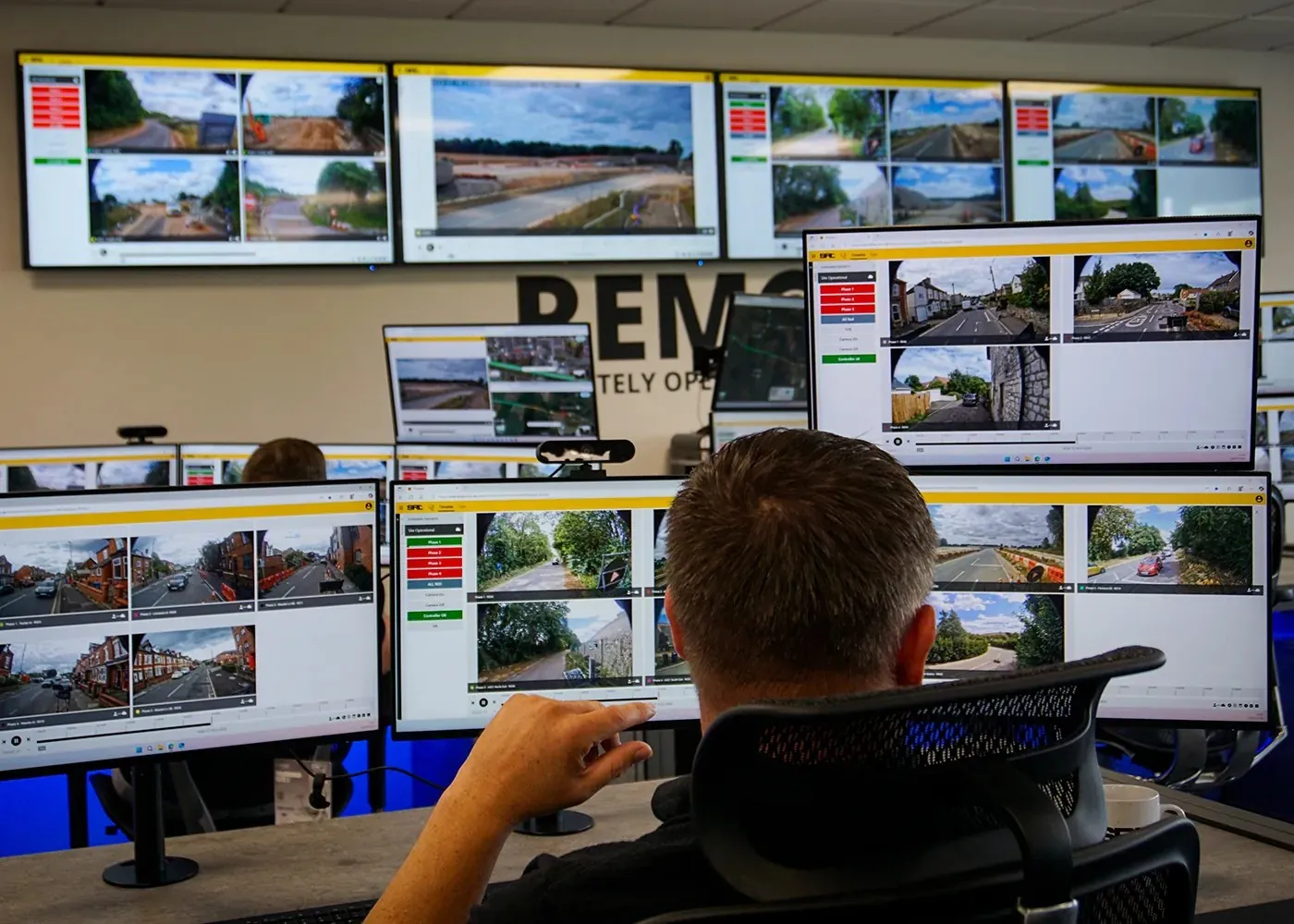
Visitors to the site have access to over 125 webcams to view current road conditions on major regional corridors and at key locations.
The site was created by IRF member,2698 Delcan Corporation, in association with Information Systems & Management Consultants, CGI.
The iMove system was developed as the first phase of the Regional Advanced Traveller Information (ATIS) strategy of the British Colombia (BC) Provincial Intelligent Transportation Systems' (ITS) Vision and Strategic Plan. The plan was developed by TransLink's subsidiary, the ITS Corporation, with the aim of using advanced technologies to help solve provincial, regional and local transportation issues. TransLink awarded Delcan the contract to design and deploy the ATIS for the Greater Vancouver Region.
The primary objective of iMove is to provide access to accurate, timely and reliable information, so as to empower users to make better transportation choices, including, for example, deferring or cancelling a trip, changing modes or selecting a different route based on current conditions.
The plan is to deliver sufficient information to enable hybrid or multi-modal trip options. The information is available in a wide variety of customisable formats including voice-synthesised information bulletins, short messages and sophisticated map-based displays featuring adequate geographical coverage, personalised access and decision guidance as well as convenient access and speed.
During the development of the operations concept of the regional ATIS, the project team identified the major goal of the initiative as providing users with a one-stop public web portal giving real-time traveller information, based on existing and prospective information resources derived from member agencies and integrated into a unified traveller service.
The design process considered institutional issues, technology, operation and maintenance, and included the definition and outline of the Regional ATIS service. In addition to providing a functional concept, the design offered very cost effective and viable solutions for project execution and immediate system implementation, as well as a feasible integration path for future project phases that will come online as new data sources and dissemination technologies are implemented.
The design is in line with the ITS architecture of Canada, and incorporates the latest1606 Institute of Transportation Engineers (ITE) and 1608 National Transportation Communications for ITS Protocol (NTCIP) standards for data exchange so as to support integration with other ITS centres publishing traveller information.
The web portal architecture was developed in accordance with respective guidelines for presentation of ITS information, developed by1609 ENTERPRISE, and web accessibility, by the 1610 World Wide Web Consortium.
The regional ATIS initiative was planned for implementation over three distinct phases:
• Phase 1: Integration of existing information sources, and any other feasible sources that come online during the deployment period, and dissemination via a public web portal;
• Phase 2: Addition of other sources of data as they come online as well as new information sources as generated by latest deployments pursued independently by the member agencies; addition of mode-choice planning tools and support for additional dissemination technologies, such as phones, personal digital assistants (PDAs), e-mail and kiosks.
• Phase 3: ATIS initiatives requiring larger capital investments, such as predictive systems and/or systems that require a high-degree of data fusion from multiple sources and agencies.
The current iMove web portal represents the realisation of Phase 1.The cornerstone of the portal is a feature-rich interactive map, based on the1224 Google Maps service, which presents layers of traveller information customised to the chosen mode of travel. The iMove system obtains real-time information (for example traffic flows and CCTV cameras) from the Ministry of Transportation, City of Vancouver, Port of Vancouver, the Weather Network, the 914 Washington State Department of Transportation (DOT), Metro Vancouver municipalities and major project teams. The portal also provides links to private transportation operators in order to obtain a full picture of travel options.
A direct interface to the Provincial DRIVE BC system allows highway related incidents and construction to be inputted directly into iMove.
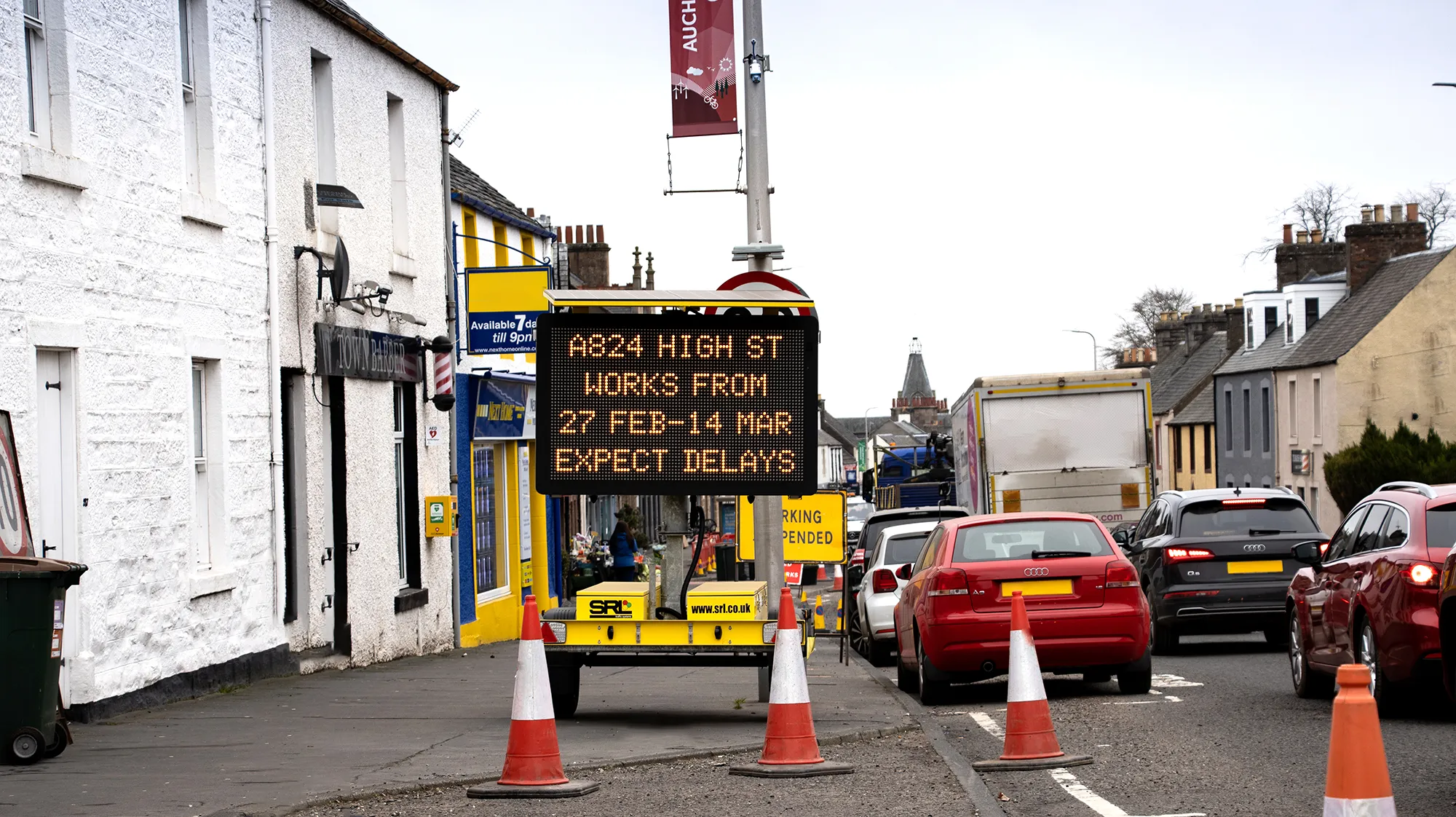
Municipalities throughout Metro Vancouver are actively using a module called Regional Condition Reporting System (RCRS) to enter information into iMove. This feature allows users to avoid municipal construction zones and, thereby, minimise congestion as well as reduce accident potential.
The iMove web portal enables the user to see current incident and congestion information in a graphical form through the use of toggle switches. The system makes it possible to view road, rail, marine and air travel networks at the same time. Travellers have the means to view the locations of all traffic and border cameras situated on the same map. The interactivity of the map presents users with the ability to customise the view to fit their individual travelling needs.
Finally, the map is designed to permit users to zoom into specific regions and then pan across, allowing for greater control.
Incident, construction and event information, along with transit and border delay information and news, are available from both the interactive map and a more detailed tabular grid; so as to provide access to descriptions of issues that travellers may need to take into consideration when planning their trips. This information includes a filter to exclude information that does not apply to the area a given traveller is interested in.
The web portal has received significant marketing, communications and branding support, effectively creating a consumer product rather than simply a traveller information web site.
The current features and future improvements of the iMove web portal will enhance the availability of traveller information throughout the region. Generally, it is expected that improved traveller information will promote better traffic flows and reduce accident potential. Some features have direct safety related benefits while others provide improved content and functionality.
In the short term, the following additional features are expected to be available on iMove soon:
• Reporting on emergency incidents affecting transportation via a direct interface to E-Comm (the 9-1-1 emergency communications service for Metro Vancouver and Southwest British Colombia) will draw interest from traffic radio stations and effectively bring iMove directly into vehicles. It is expected that users will be able to avoid incident locations, thereby minimising the potential for secondary incidents and promoting smoother traffic flow throughout the network.
• Municipalities and other agencies have deployed or are planning to deploy additional webcams that will be hosted on iMove to enable users to confirm the real-time status of traffic in the given areas.
• Real-time service levels for the SkyTrain system will support transit use and reduce vehicular traffic volumes.
• Advisories will be available for major events, to allow the public either to access the events more easily or avoid them as desired.
• Additional content to promote alternative transportation and reduce vehiclular volumes.
• Additional data from Washington State DOT, including congestion at border crossing approaches, will minimise congestion at ports of entry.
• Information from the Vancouver Fraser Port Authority.
Together, this information will be available to agencies such as E-Comm, municipal emergency services, transit security and safety, traffic media and Ministry of Transportation maintenance contractors and service providers. Thanks to the system, these agencies will have access to better information before and during any response to emergencies. iMove is also the only location where E-Comm and municipal information is available directly to the public.
In the longer term, subject to funding, iMove will be developed further and is expected to incorporate other features such as:
• Greater access via portable media devices.
• Expanded coverage.
• Improved data through deployment of additional traffic detectors throughout the region.
• Integration of iMove into a central booking and vehicle tracking system for para-transit.
• Real-time bus arrival information.
• Improved trip planning for additional modes.
• Elements of iMove available in the provincial 511 initiative (free phone number for weather and traveller information).
The November, 2007 launch of the web portal completed the basic development of the site and was the first deployment of the ITS Corporation. TransLink is the current steward of iMove and will develop the future enhancements.
The iMove web portal has been recognised by neighbouring jurisdictions, which are investigating the possibility of integrating their own information systems and becoming "iMove communities".
Nationally, the iMove web portal, with its use of the latest technology and branding as a consumer product, is considered by many as a showcase for Canada in ATIS. Regionally, iMove is viewed as the first step towards a vision of a multi-modal, integrated and seamless transportation network in Metro Vancouver.RSS
As the world descended on Vancouver for the 2010 Winter Olympics, visitors were able to travel around the city with confidence and intelligence thanks to a landmark project by IRF Member, Delcan
On 26 November, 2007,The iMove website enables transportation consumers in Metro Vancouver to access information quickly, and from a single source, on a host of transportation issues including transit and cycling routes, construction and event information, current incidents, airline arrivals and departures, border crossing wait times, and ferry sailing times and loadings.
Visitors to the site have access to over 125 webcams to view current road conditions on major regional corridors and at key locations.
The site was created by IRF member,
The iMove system was developed as the first phase of the Regional Advanced Traveller Information (ATIS) strategy of the British Colombia (BC) Provincial Intelligent Transportation Systems' (ITS) Vision and Strategic Plan. The plan was developed by TransLink's subsidiary, the ITS Corporation, with the aim of using advanced technologies to help solve provincial, regional and local transportation issues. TransLink awarded Delcan the contract to design and deploy the ATIS for the Greater Vancouver Region.
The primary objective of iMove is to provide access to accurate, timely and reliable information, so as to empower users to make better transportation choices, including, for example, deferring or cancelling a trip, changing modes or selecting a different route based on current conditions.
The plan is to deliver sufficient information to enable hybrid or multi-modal trip options. The information is available in a wide variety of customisable formats including voice-synthesised information bulletins, short messages and sophisticated map-based displays featuring adequate geographical coverage, personalised access and decision guidance as well as convenient access and speed.
During the development of the operations concept of the regional ATIS, the project team identified the major goal of the initiative as providing users with a one-stop public web portal giving real-time traveller information, based on existing and prospective information resources derived from member agencies and integrated into a unified traveller service.
The design process considered institutional issues, technology, operation and maintenance, and included the definition and outline of the Regional ATIS service. In addition to providing a functional concept, the design offered very cost effective and viable solutions for project execution and immediate system implementation, as well as a feasible integration path for future project phases that will come online as new data sources and dissemination technologies are implemented.
The design is in line with the ITS architecture of Canada, and incorporates the latest
The web portal architecture was developed in accordance with respective guidelines for presentation of ITS information, developed by
The regional ATIS initiative was planned for implementation over three distinct phases:
• Phase 1: Integration of existing information sources, and any other feasible sources that come online during the deployment period, and dissemination via a public web portal;
• Phase 2: Addition of other sources of data as they come online as well as new information sources as generated by latest deployments pursued independently by the member agencies; addition of mode-choice planning tools and support for additional dissemination technologies, such as phones, personal digital assistants (PDAs), e-mail and kiosks.
• Phase 3: ATIS initiatives requiring larger capital investments, such as predictive systems and/or systems that require a high-degree of data fusion from multiple sources and agencies.
The current iMove web portal represents the realisation of Phase 1.The cornerstone of the portal is a feature-rich interactive map, based on the
A direct interface to the Provincial DRIVE BC system allows highway related incidents and construction to be inputted directly into iMove.
Municipalities throughout Metro Vancouver are actively using a module called Regional Condition Reporting System (RCRS) to enter information into iMove. This feature allows users to avoid municipal construction zones and, thereby, minimise congestion as well as reduce accident potential.
The iMove web portal enables the user to see current incident and congestion information in a graphical form through the use of toggle switches. The system makes it possible to view road, rail, marine and air travel networks at the same time. Travellers have the means to view the locations of all traffic and border cameras situated on the same map. The interactivity of the map presents users with the ability to customise the view to fit their individual travelling needs.
Finally, the map is designed to permit users to zoom into specific regions and then pan across, allowing for greater control.
Incident, construction and event information, along with transit and border delay information and news, are available from both the interactive map and a more detailed tabular grid; so as to provide access to descriptions of issues that travellers may need to take into consideration when planning their trips. This information includes a filter to exclude information that does not apply to the area a given traveller is interested in.
The web portal has received significant marketing, communications and branding support, effectively creating a consumer product rather than simply a traveller information web site.
The current features and future improvements of the iMove web portal will enhance the availability of traveller information throughout the region. Generally, it is expected that improved traveller information will promote better traffic flows and reduce accident potential. Some features have direct safety related benefits while others provide improved content and functionality.
In the short term, the following additional features are expected to be available on iMove soon:
• Reporting on emergency incidents affecting transportation via a direct interface to E-Comm (the 9-1-1 emergency communications service for Metro Vancouver and Southwest British Colombia) will draw interest from traffic radio stations and effectively bring iMove directly into vehicles. It is expected that users will be able to avoid incident locations, thereby minimising the potential for secondary incidents and promoting smoother traffic flow throughout the network.
• Municipalities and other agencies have deployed or are planning to deploy additional webcams that will be hosted on iMove to enable users to confirm the real-time status of traffic in the given areas.
• Real-time service levels for the SkyTrain system will support transit use and reduce vehicular traffic volumes.
• Advisories will be available for major events, to allow the public either to access the events more easily or avoid them as desired.
• Additional content to promote alternative transportation and reduce vehiclular volumes.
• Additional data from Washington State DOT, including congestion at border crossing approaches, will minimise congestion at ports of entry.
• Information from the Vancouver Fraser Port Authority.
Together, this information will be available to agencies such as E-Comm, municipal emergency services, transit security and safety, traffic media and Ministry of Transportation maintenance contractors and service providers. Thanks to the system, these agencies will have access to better information before and during any response to emergencies. iMove is also the only location where E-Comm and municipal information is available directly to the public.
In the longer term, subject to funding, iMove will be developed further and is expected to incorporate other features such as:
• Greater access via portable media devices.
• Expanded coverage.
• Improved data through deployment of additional traffic detectors throughout the region.
• Integration of iMove into a central booking and vehicle tracking system for para-transit.
• Real-time bus arrival information.
• Improved trip planning for additional modes.
• Elements of iMove available in the provincial 511 initiative (free phone number for weather and traveller information).
The November, 2007 launch of the web portal completed the basic development of the site and was the first deployment of the ITS Corporation. TransLink is the current steward of iMove and will develop the future enhancements.
The iMove web portal has been recognised by neighbouring jurisdictions, which are investigating the possibility of integrating their own information systems and becoming "iMove communities".
Nationally, the iMove web portal, with its use of the latest technology and branding as a consumer product, is considered by many as a showcase for Canada in ATIS. Regionally, iMove is viewed as the first step towards a vision of a multi-modal, integrated and seamless transportation network in Metro Vancouver.RSS