The world’s best road infrastructure project can also have the world’s worst traffic noise problem. But where to start defeating this noise pollution? Road traffic noise is one of the most obvious aspects affecting the quality of life in urban areas. To combat this, local, national and international authorities have developed initiatives to avoid, prevent or reduce exposure to noise. One of these initiatives – Life DYNAMAP – is underway by a group of researchers in Germany, Spain and Italy. The project is f
The world’s best road infrastructure project can also have the world’s worst traffic noise problem. But where to start defeating this noise pollution?
Road traffic noise is one of the most obvious aspects affecting the quality of life in urban areas. To combat this, local, national and international authorities have developed initiatives to avoid, prevent or reduce exposure to noise.
One of these initiatives – Life DYNAMAP – is underway by a group of researchers in Germany, Spain and Italy. The project is focused on the creation of noise level maps, as the project’s leaders* explain. Life DYNAMAP will provide a guideline for the design and implementation of real time noise mapping. Data from the project will allow local authorities as well as national and international organisations to plan mitigation strategies and tactics.
A major driving force behind initiatives such as Life DYNAMAP is the Directive 2002/49/EC of the European Parliament and of the Council related to the assessment and management of environmental noise. This European Noise Directive, or END, considers the creation of easily read noise maps to inform the public about noise levels.
Moreover, to take into account changes in environmental conditions - mainly traffic, mobility and urban development - END imposes a mandatory update of noise level maps every five years. Currently, updating noise level maps requires the collection of new data over a reference period, followed by the processing of this data using complex acoustic models to produce an updated noise map. This procedure is expensive and time consuming for the authorities.
To ease the updating of noise maps and reduce the cost involved, the Life DYNAMAP initiative proposes an integrated system for data acquisition and processing to report in real time road infrastructure noise levels. This will require the development of low-cost sensor networks. The work has already been awarded more than €1 million by the European Commission under the LIFE+ 2013 programme, but the total project budget is over €2.2 million.
Life DYNAMAP is spanning five years, from July 2014 to July 2019, and is a joint effort between several partners from Italy, Germany and Spain. The project’s consortium includes road infrastructure authorities, mobility and environmental agencies, local authorities, private companies and universities. Overall project coordination is by1184 ANAS, the Italian government agency for road design, construction and maintenance.
This assessment will be first carried out in two pilot areas and then extended to the whole network managed by ANAS and to Milan. Preliminary indications are the automation of noise-level map updating brings savings of about 50%; an estimated cost of about €500/km.
It seems plausible that from the noise-level maps it will be possible to identify the most critical areas in terms of noise pollution. From this data, it should also be possible to efficiently design and address action plans to mitigate the impact of noise on people who live and work in those areas. Solutions might include construction of acoustic barriers, the installation of low-noise pavements or the promotion of traffic-calming policies.
Thanks to the dynamic nature of the noise-level maps, new algorithms could be developed to detect high levels of traffic noise in certain areas at a specific moment. The information could be used with short-term corrective purposes, such as the development of an early warning system based on the interconnection between the Life DYNAMAP system and electronic roadside information boards. This would inform drivers of alternate routes or display messages addressed to reduce current noise levels, such as displaying maximum speed limits adapted to traffic conditions or notices that ban heavy vehicles.
The next most important step was to locate the two pilot Life DYNAMAP systems. To address the pilot areas selection, a support tool was designed to guide the data collection process. Such tools consider environmental and infrastructure factors, including noise levels, population density, number of dwellings and people exposed to noise as well as the presence of additional noise sources. Other information was collated, including traffic counting sensors, meteorological and air quality stations, communication networks and electric power connections.
The candidate pilot areas were ranked based on how they satisfied the ideal conditions. As a result, Milan’s district nine was chosen as the urban pilot area. As for the suburban scenario, a total of 17 critical areas located along the A90 motorway in suburban Rome were selected.
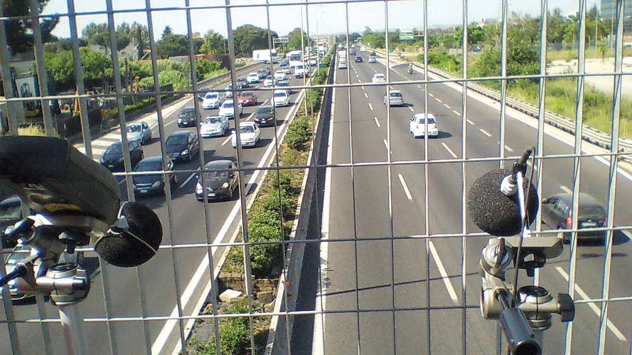
Life DYNAMAP system will also be able to distinguish between road traffic noise and other types of acoustic events - aircraft, industrial, nearby road works. These will be excluded from the noise level computation. But to do this, it is necessary to build an accurate acoustic model of road traffic noise. For this reason, a dual noise recording campaign in both pilot areas was completed. This uses both a professional sound level meter and the low-cost sensor that will be employed in Life DYNAMAP monitoring stations.
Lastly, dissemination of the outcomes of the project is an important activity. For this reason, many events have been planned to inform the public about the results of the project. In July, a special session, including a panel discussion, on the project was conducted during the International Conference on Sound and Vibration held in Florence, Italy.
*Xavier Sevillano and Francesc Alías at La Salle Universitat Ramon Llull in Barcelona, Spain, and Patrizia Bellucci at ANAS in Italy.
Life DYNAMAP: Objectives
The first goal is development of low-cost sensors and tools for managing, processing and reporting real-time noise maps on a GIS platform with the aim of automating the noise mapping process.
Partners are: Blue Wave, an Italian company that develops and manufactures low-cost electro acoustic devices and acoustic measurement systems; ACCON, a German company focusing on noise monitoring and mapping; Università degli Studi di Milano-Bicocca, Milan-based researcher group in the field of acoustic monitoring and noise mapping; and Barcelona’s La Salle Universitat Ramon Llull, involving researchers in audio processing and recognition.
The second goal is the design and implementation of pilot systems in Milan and Rome.
The first pilot will cover a significant portion of Milan, while the second one will be located along a major road encircling Rome. Partners involved will be groups working in the field of road infrastructure and mobility management, ANAS, the municipality of Milan and AMAT - the mobility and environmental agency of the municipality of Milan.
The two pilot systems will be monitored for at least one year to check criticalities and to analyse problems and faults. Test results will then be used to suggest system upgrades and to extend its implementation to other environmental parameters.
Road traffic noise is one of the most obvious aspects affecting the quality of life in urban areas. To combat this, local, national and international authorities have developed initiatives to avoid, prevent or reduce exposure to noise.
One of these initiatives – Life DYNAMAP – is underway by a group of researchers in Germany, Spain and Italy. The project is focused on the creation of noise level maps, as the project’s leaders* explain. Life DYNAMAP will provide a guideline for the design and implementation of real time noise mapping. Data from the project will allow local authorities as well as national and international organisations to plan mitigation strategies and tactics.
A major driving force behind initiatives such as Life DYNAMAP is the Directive 2002/49/EC of the European Parliament and of the Council related to the assessment and management of environmental noise. This European Noise Directive, or END, considers the creation of easily read noise maps to inform the public about noise levels.
Moreover, to take into account changes in environmental conditions - mainly traffic, mobility and urban development - END imposes a mandatory update of noise level maps every five years. Currently, updating noise level maps requires the collection of new data over a reference period, followed by the processing of this data using complex acoustic models to produce an updated noise map. This procedure is expensive and time consuming for the authorities.
To ease the updating of noise maps and reduce the cost involved, the Life DYNAMAP initiative proposes an integrated system for data acquisition and processing to report in real time road infrastructure noise levels. This will require the development of low-cost sensor networks. The work has already been awarded more than €1 million by the European Commission under the LIFE+ 2013 programme, but the total project budget is over €2.2 million.
Life DYNAMAP is spanning five years, from July 2014 to July 2019, and is a joint effort between several partners from Italy, Germany and Spain. The project’s consortium includes road infrastructure authorities, mobility and environmental agencies, local authorities, private companies and universities. Overall project coordination is by
Short- and long-term benefits of the project
Besides the purely technical challenges and activities foreseen in the project, a very relevant aspect will be the assessment of the costs and benefits of automated mapping.This assessment will be first carried out in two pilot areas and then extended to the whole network managed by ANAS and to Milan. Preliminary indications are the automation of noise-level map updating brings savings of about 50%; an estimated cost of about €500/km.
It seems plausible that from the noise-level maps it will be possible to identify the most critical areas in terms of noise pollution. From this data, it should also be possible to efficiently design and address action plans to mitigate the impact of noise on people who live and work in those areas. Solutions might include construction of acoustic barriers, the installation of low-noise pavements or the promotion of traffic-calming policies.
Thanks to the dynamic nature of the noise-level maps, new algorithms could be developed to detect high levels of traffic noise in certain areas at a specific moment. The information could be used with short-term corrective purposes, such as the development of an early warning system based on the interconnection between the Life DYNAMAP system and electronic roadside information boards. This would inform drivers of alternate routes or display messages addressed to reduce current noise levels, such as displaying maximum speed limits adapted to traffic conditions or notices that ban heavy vehicles.
What has been accomplished so far?
As a first step, an in-depth analysis of the available state-of-the-art mapping systems for dynamic noise was completed so Life DYNAMAP can take into account the latest advances.The next most important step was to locate the two pilot Life DYNAMAP systems. To address the pilot areas selection, a support tool was designed to guide the data collection process. Such tools consider environmental and infrastructure factors, including noise levels, population density, number of dwellings and people exposed to noise as well as the presence of additional noise sources. Other information was collated, including traffic counting sensors, meteorological and air quality stations, communication networks and electric power connections.
The candidate pilot areas were ranked based on how they satisfied the ideal conditions. As a result, Milan’s district nine was chosen as the urban pilot area. As for the suburban scenario, a total of 17 critical areas located along the A90 motorway in suburban Rome were selected.
Life DYNAMAP system will also be able to distinguish between road traffic noise and other types of acoustic events - aircraft, industrial, nearby road works. These will be excluded from the noise level computation. But to do this, it is necessary to build an accurate acoustic model of road traffic noise. For this reason, a dual noise recording campaign in both pilot areas was completed. This uses both a professional sound level meter and the low-cost sensor that will be employed in Life DYNAMAP monitoring stations.
Lastly, dissemination of the outcomes of the project is an important activity. For this reason, many events have been planned to inform the public about the results of the project. In July, a special session, including a panel discussion, on the project was conducted during the International Conference on Sound and Vibration held in Florence, Italy.
*Xavier Sevillano and Francesc Alías at La Salle Universitat Ramon Llull in Barcelona, Spain, and Patrizia Bellucci at ANAS in Italy.
Life DYNAMAP: Objectives
The first goal is development of low-cost sensors and tools for managing, processing and reporting real-time noise maps on a GIS platform with the aim of automating the noise mapping process.
Partners are: Blue Wave, an Italian company that develops and manufactures low-cost electro acoustic devices and acoustic measurement systems; ACCON, a German company focusing on noise monitoring and mapping; Università degli Studi di Milano-Bicocca, Milan-based researcher group in the field of acoustic monitoring and noise mapping; and Barcelona’s La Salle Universitat Ramon Llull, involving researchers in audio processing and recognition.
The second goal is the design and implementation of pilot systems in Milan and Rome.
The first pilot will cover a significant portion of Milan, while the second one will be located along a major road encircling Rome. Partners involved will be groups working in the field of road infrastructure and mobility management, ANAS, the municipality of Milan and AMAT - the mobility and environmental agency of the municipality of Milan.
The two pilot systems will be monitored for at least one year to check criticalities and to analyse problems and faults. Test results will then be used to suggest system upgrades and to extend its implementation to other environmental parameters.