UK’s M3 motorway gets first orange emergency area

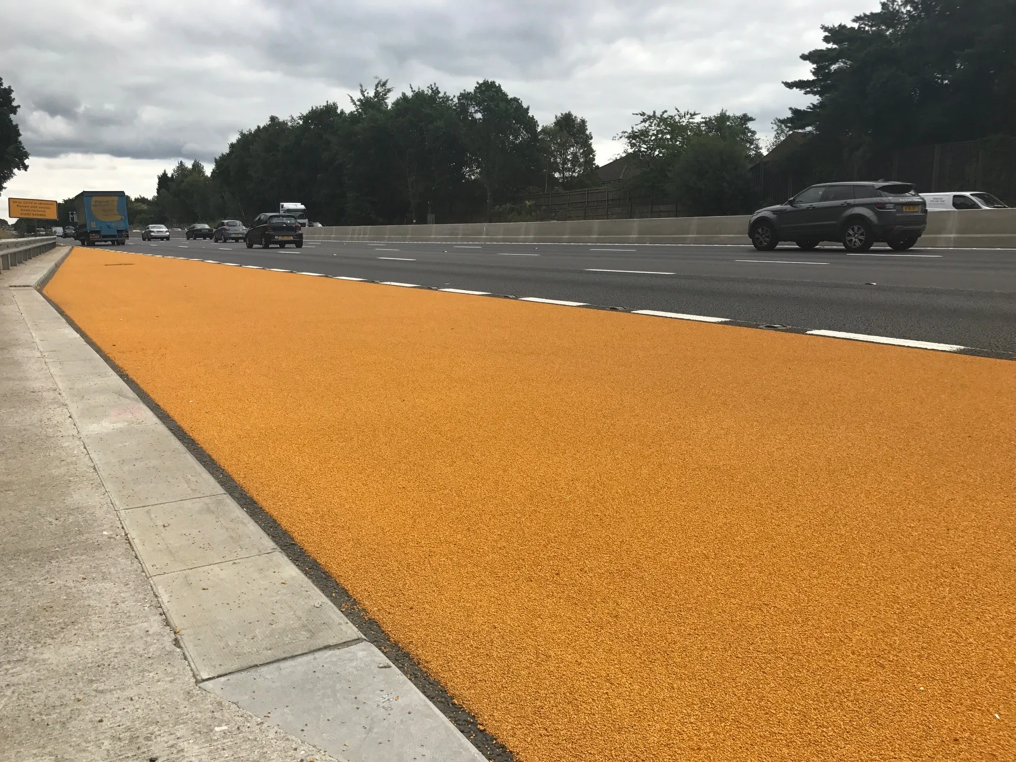
The first of a new-style smart motorway emergency stop area is being trialled on the M3 in England. The redesigned emergency area has a highly visible orange road surface and better signs to improve its visibility, according to Highways England, the wholly government-owned company responsible for modernising, maintaining and operating England’s motorways and major A roads.
August 1, 2017 Read time: 2 mins
Safer with an orange: Emergency Refuge Areas using QMS Type 1 HyperGrip system

The first of a new-style smart motorway emergency stop area is being trialled on the M3 in England.

The redesigned emergency area has a highly visible orange road surface and better signs to improve its visibility, according to 8100 Highways England, the wholly government-owned company responsible for modernising, maintaining and operating England’s motorways and major A roads.

Work on the officially-called Emergency Refuge Areas is being done by 8037 WJ in collaboration with maintenance contractors 1146 Balfour Beatty and 184 Colas.

Smart motorways relieve congestion and improve journey times by making the hard shoulder available for use at busy periods. On some schemes, it is permanently converted into a traffic lane, known as All Lane Running.

Spaced emergency refuge areas - ERA - are provided roughly every 2.5km and are clearly marked with blue signs featuring an orange SOS telephone symbol.

This safety upgrade, using QMS Type 1 HyperGrip system, has been delivered on the 21.5km smart motorway scheme, which covers the M3 from junctions 2-4a in Hampshire and Surrey counties. Two emergency refuge areas were completed as z trial and now all ERA’s on the scheme will be afforded the same enhancement.

It is planned now to apply this coloured system on all ERA’s throughout the scheme with other smart motorway contracts expressing interest.

The change is part of an ongoing review into the design and spacing of emergency areas on smart motorways, said Jim O’Sullivan, Highways England chief executive.

Quality Marking Services
%$Linker: 2 External <?xml version="1.0" encoding="utf-16"?><dictionary /> 0 0 0 oLinkExternal www.qmarkings.co.uk Quality Marking Services Website Link false http://www.qmarkings.co.uk/ false false%>

For more information on companies in this article

Related Content

  • More efficient ground stabilisation with the Allu 3D Positioning System
    April 19, 2013
    The Allu 3D Positioning System will make ground stabilisation works more efficient and more cost-effective, according to the Finnish manufacturer. The GPS-guided system works in conjunction with Allu’s PMX mixing head, which is mounted on an excavator. It is made up from four modules – computer unit with software, touch screen, base station and GPS antennas positioned on the mixing unit. Often used in road construction to firm up soft ground, the ground stabilisation process sees the binder material fed in
  • Doosan launches small wheeled loader at INTERMAT
    January 6, 2017
    With a bucket capacity of two cubic metres, the DL200-3 is another in the Doosan line that benefits from a stage IIIB emissions compliant engine. And with it, Doosan has taken the opportunity to freshen up the 12,200kg loader. In addition to the 118kW DL06 engine, the loader gets a new cab offering better visibility, a revised hydraulic system with load sensing, and ZF axles with limited slip differentials.
  • Doosan launches small wheeled loader at INTERMAT
    March 16, 2012
    With a bucket capacity of two cubic metres, the DL200-3 is another in the Doosan line that benefits from a stage IIIB emissions compliant engine. And with it, Doosan has taken the opportunity to freshen up the 12,200kg loader. In addition to the 118kW DL06 engine, the loader gets a new cab offering better visibility, a revised hydraulic system with load sensing, and ZF axles with limited slip differentials.
  • Topcon launches new subscription based web services
    August 17, 2012
    Topcon has restructured its GNSS network business and global GNSS services, offering new and informative web resources for users. TopNET is said to offer subscription based, real-time GNSS network RTK and DGNSS subscriptions, with high quality GPS and GLONASS correction data, as well as all future GNSS signals, for many different applications; including surveying, construction, GIS mapping, machine control, and precision agriculture.