Measuring night and day visibility of road markings

Box International studies have proven that relatively more accidents and fatalities happen during night-time driving compared to day-time driving. At the end of 2008, Danish company DELTA launched its latest model, the LTL-XL, a fourth generation portable retrometer for measuring night and day-time visibility of all types of road markings. "Measures are traceable to PTB (Physikalisch-Technische Bundesanstalt), Germany and NIST (National Institute of Standards), USA. LTL-XL measures according to the internat
April 12, 2012 Read time: 2 mins
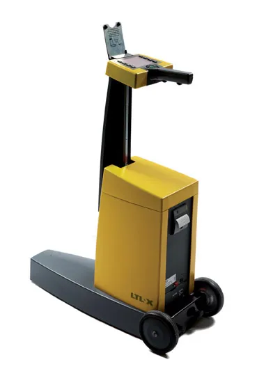
The LTL-XL from DELTA: built in modules

Box International studies have proven that relatively more accidents and fatalities happen during night-time driving compared to day-time driving.

At the end of 2008, Danish company 199 Delta launched its latest model, the LTL-XL, a fourth generation portable retrometer for measuring night and day-time visibility of all types of road markings.

"Measures are traceable to PTB (3998 Physikalisch-Technische Bundesanstalt), Germany and NIST (National Institute of Standards and Technology), USA. LTL-XL measures according to the international standards EN1436 and ASTM E-1710," says DELTA.

Its LTL-XL offers several new features compared to previous instruments from DELTA and these include the measuring of the ambient temperature and humidity; geotagging using GPS mapping software; USB connectivity and seamless connection to any system using a Web browser.
LTL-XL full instrument
The LTL-XL from DELTA: built in modules
The new equipment is offered with a new coloured display, single-handed operation and single touch controls, which makes the operator's work much easier.

Using LED technology, which makes the instrument almost maintenance free, LTL-XL allows users to work efficiently with measuring times of 1-3 seconds and a large memory of more than 200,000 measurements.

"LTL-XL is built in modules to allow the operator to design the instrument according to actual needs. It comes in a base model to which can be added wheels and telescopic handle, GPS and printer," says DELTA.

For more information on companies in this article

Related Content

  • Topcon’s action station
    October 31, 2012
    Topcon Europe Positioning (TEP) has launched a new, professional-grade robotic total station – the PS series – which the firm says is designed to surpass the power, accuracy and capabilities of its peers. The PS is said to utilise Topcon’s new PowerTrac technology to increase the prism tracking power. “Using new optics, laser system and advanced algorithms, PowerTrac provides the PS with the ability to keep tracking a moving prism even under the toughest environmental conditions,” said Leighton Davies, surv
  • New marking technologies being developed
    June 30, 2014
    Innovative roadmarking technologies will increase productivity, improve conspicuity in poor conditions and offer increased wear life - Mike Woof writes. Major advances have been seen in roadmarking systems now being offered on the market. More sophisticated machinery will increase productivity and quality when installing markings, while new systems will also last longer in use. In addition, smart technologies can detect wear and provide highway authorities with an accurate picture of network safety, at comp
  • GPS machine control boosts road surface quality
    February 14, 2012
    The use of GPS machine control on sub-base has improved final rideability on a major highway reconstruction project. Innovative construction techniques have helped to upgrade a 9.6km stretch of the 307km long I-96 highway in the US state of Michigan. The Michigan Department of Transportation (MDOT) project was initiated in the third quarter of 2009 and was completed in the fourth quarter of 2010. Interstate Highway Construction acted as general contractor on the project, which included widening the shoulder
  • MOBA’s World Cup highway mission
    April 23, 2013
    The Kaliningrad motorway Primorsk Ring is one of the prestige projects under construction within the scope of infrastructure improvements in the Russian exclave. With a total length of around 180kms, of which 81kms are motorway, the ring road will encircle the 500,000 residents of Kaliningrad city in a broad arc around the Samland peninsula.