'Five innovations in one'

The new ZRM 6014 road marking retroreflectometer from Zehntner is said to incorporate five innovations in one go: telescope handle and wheels as standard, colour touch display, camera, level meter and compass.
February 9, 2012 Read time: 2 mins
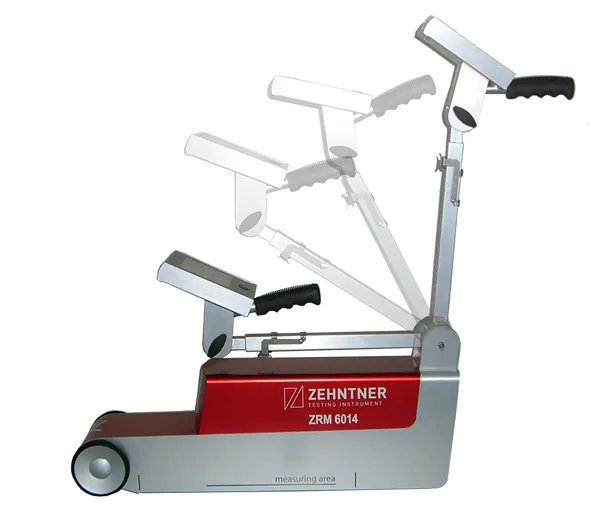
Zehntner's new ZRM 6014 road marking retroreflectometer "incorporates five innovations in one go"

The new ZRM 6014 road marking retroreflectometer from Zehntner is said to incorporate five innovations in one go: telescope handle and wheels as standard, colour touch display, camera, level meter and compass.

"The main focus has been put on speeding up the measuring process of road markings. RL and Qd are measured in about two seconds: single measurements of RL or Qd take only one second each," says managing director Peter 1285 Zehntner.

"Somebody who has actually been on the road for measurements knows that speed is of the essence." As well as the RL and Qd values temperature and air humidity are recorded simultaneously. Extensive options to configure the instrument include a level meter to determine the gradient of the road; a compass that indicates the orientation and a GPS receiver allows precise positioning of the results. As standard, all this information can be displayed on mapping software for easy evaluation.

An optional built-in camera allows the user to get a picture of the marking from the point of view of the measuring instrument, which is said to be helpful when in doubt during the evaluation of critical results.

Data can be transferred to a PC or memory stick within seconds, and a built-in printer can print measuring results on the spot.

For more information on companies in this article

Related Content

  • Crossing the Alps for five decades
    March 24, 2020
    Italy’s A22 Autostrada route is a key transport connection for Europe and also a model for efficient operational management
  • Trimble offers advanced dozer machine control solution
    February 28, 2018
    Trimble is now introducing its Earthworks for Dozers package, following on from the Earthworks for Excavators system unveiled last year. The Earthworks Grade Control System for Dozers uses the same inertial motion sensors (IMUs) as the excavator package and mounts its dual GNSS receivers on top of the cab to eliminate masts and cables conventionally located on the blade. The dual GNSS receivers suit steep slope work and complex designs with tight tolerances. The new configuration keeps valuable receivers
  • Machine control technology round table discussion with Leica Geosystems, Topcon and Trimble
    January 4, 2022
    In this, the first in a series of top-level roundtable discussions led by World Highways, editor Mike Woof and editorial director Geoff Hadwick talk machine control technology with three world-class experts from Leica Geosystems, part of Hexagon, Topcon and Trimble. Find out what these key opinion leaders are thinking on six vitally important topics. Let them help you stay ahead of the game.
  • Efficient stockpile and site monitoring
    October 23, 2017
    Effective monitoring of aggregates stockpiles as well as face excavation can deliver greater quarrying efficiency. One of the latest innovations in quarrying is the use of drones, which provide major benefits for optimising operations. The use of affordable drone hardware and software solutions can help reduce stockpile inventory time by as much as 70%. Through the recent partnership between Trimble and Propeller, drone data can now be an everyday tool in quarries by proving a transformational impact