'Five innovations in one'

The new ZRM 6014 road marking retroreflectometer from Zehntner is said to incorporate five innovations in one go: telescope handle and wheels as standard, colour touch display, camera, level meter and compass.
February 9, 2012 Read time: 2 mins
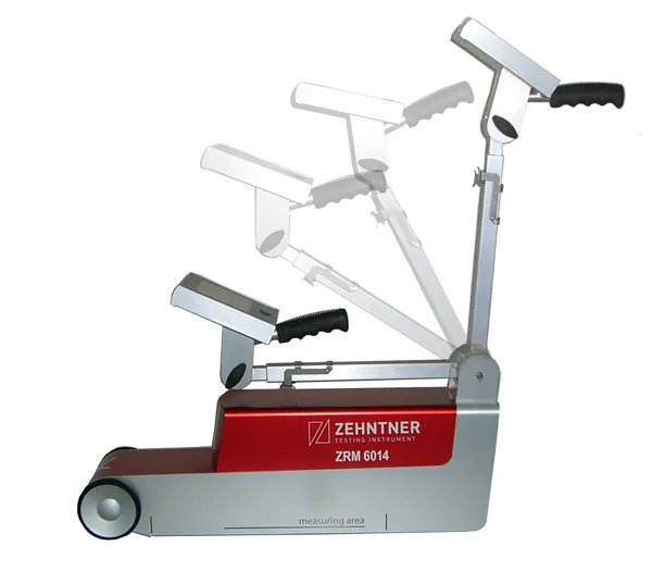
Zehntner's new ZRM 6014 road marking retroreflectometer "incorporates five innovations in one go"

The new ZRM 6014 road marking retroreflectometer from Zehntner is said to incorporate five innovations in one go: telescope handle and wheels as standard, colour touch display, camera, level meter and compass.

"The main focus has been put on speeding up the measuring process of road markings. RL and Qd are measured in about two seconds: single measurements of RL or Qd take only one second each," says managing director Peter 1285 Zehntner.

"Somebody who has actually been on the road for measurements knows that speed is of the essence." As well as the RL and Qd values temperature and air humidity are recorded simultaneously. Extensive options to configure the instrument include a level meter to determine the gradient of the road; a compass that indicates the orientation and a GPS receiver allows precise positioning of the results. As standard, all this information can be displayed on mapping software for easy evaluation.

An optional built-in camera allows the user to get a picture of the marking from the point of view of the measuring instrument, which is said to be helpful when in doubt during the evaluation of critical results.

Data can be transferred to a PC or memory stick within seconds, and a built-in printer can print measuring results on the spot.

For more information on companies in this article

Related Content

  • More efficient ground stabilisation with the Allu 3D Positioning System
    January 6, 2017
    The Allu 3D Positioning System will make ground stabilisation works more efficient and more cost-effective, according to the Finnish manufacturer. The GPS-guided system works in conjunction with Allu’s PMX mixing head, which is mounted on an excavator. It is made up from four modules – computer unit with software, touch screen, base station and GPS antennas positioned on the mixing unit. Often used in road construction to firm up soft ground, the ground stabilisation process sees the binder material fed in
  • More efficient ground stabilisation with the Allu 3D Positioning System
    April 19, 2013
    The Allu 3D Positioning System will make ground stabilisation works more efficient and more cost-effective, according to the Finnish manufacturer. The GPS-guided system works in conjunction with Allu’s PMX mixing head, which is mounted on an excavator. It is made up from four modules – computer unit with software, touch screen, base station and GPS antennas positioned on the mixing unit. Often used in road construction to firm up soft ground, the ground stabilisation process sees the binder material fed in
  • Software mapping takes on hard-to-tackle air pollution problems
    June 15, 2018
    Software mapping of air pollution along transport corridors is an important weapon for improving air quality, argues Arne Berndt*. Although power plants and factories play a large part in increasing air pollution globally, traffic is now the largest single contributor. Commercial vehicles account for a significant share of traffic around the world, with freight volumes projected to grow 40% by 2050. Yet, despite modern vehicles being more environmentally friendly than earlier models, the sheer volume of th
  • Using ITS to maximise safety and traffic flow for cycling
    January 22, 2013
    Copenhagen, Denmark, has long been known as one of the world’s leading cities for cycling. In some areas of the city, the modal share of bikes has reached a level of as much as 50 %. And on some of the most frequently used bike paths the average daily number of cyclists is close to 30,000. As these numbers continue to rise, new ways of planning and implementing cycling infrastructure are needed. Increasingly, Danish traffic planners are turning to technology as a tool for planning cycling infrastructure. I