
Location location

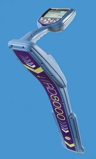
Improved underground utility location capabilities are claimed for the improved unit from Radiodetection, This new unit is a development of the RD8000 range of pipe and cable locators introduced by Radiodetection in 2008 and offers the addition of an innovative current direction (CD) feature. This is available on Radiodetection's most advanced locator the RD8000PDL and allows a user to trace and identify a target cable in highly congested areas or when running parallel to other lines.
February 28, 2012 Read time: 2 mins
The new package from Radiodetection comes with a CD function that improves locator accuracy and means that the user locates the correct pipe or cable, saving time and money eliminating wasted time following faulty trails
Improved underground utility location capabilities are claimed for the improved unit from 2537 Radiodetection, This new unit is a development of the RD8000 range of pipe and cable locators introduced by Radiodetection in 2008 and offers the addition of an innovative current direction (CD) feature. This is available on Radiodetection's most advanced locator the RD8000PDL and allows a user to trace and identify a target cable in highly congested areas or when running parallel to other lines.

The firm has developed a novel method for identifying a target cable amongst a number of parallel cables using CD direction arrows. A signal is applied to the target line using Radiodetection's Tx-10 signal transmitter and the RD8000 hand held receiver shows the direction of the current flow on the line. The target line can be identified if the receiver display arrow shows that the current is flowing away from the transmitter signal.

For more information on companies in this article

Related Content

  • Data sharing boosts workzone safety
    March 19, 2012
    Faster and safer utilities works are the benefit of innovative data sharing moves – Mike Woof writes. Utilities works in urban areas can cause major problems with regard to traffic congestion, as well as posing key safety issues for road users and site workers. Better planning of utilities operations can help tackle congestion and prevent jams, while also ensuring that on-site personnel have a safer working environment. To ensure that site workers know the exact location of buried utilities, comprehensive m
  • Sophisticated software solutions offering surveying innovation and construction efficiency
    August 28, 2014
    An array of new software tools will deliver greater efficiencies to construction companies – Mike Woof writes. Sophisticated software systems are delivering advanced solutions to traditional construction tasks. Key developments have been made by major players in the sector, such as Bentley Systems, Fugro Roadware, Leica Geosystems and Topcon Sokkia. From Bentley comes a new package that will help road construction activities in urban areas featuring a heavy concentration of underground utilities. This n
  • Accurate utilities detection
    November 26, 2024

    Trimble and Radiodetection are collaborating to improve the technology used in the utility measurement and mapping process. Integrating the Trimble Catalyst DA2 GNSS system and Radiodetection’s RD MapTM+ application and precision locator products helps to streamline utility-locating workflows to provide accurate measurement capabilities and generate underground utilities maps in a single field operation.

  • More accurate mapping
    July 31, 2024

    Trimble and Radiodetection have established a collaboration to improve the technology used in the utility measurement and mapping process. Through the integration of the Trimble Catalyst DA2 GNSS system and Radiodetection’s RD MapTM+ application and precision locator products, the software and hardware integration streamlines utility-locating workflows. This can provide high-accuracy measurement capabilities for the generation of underground utilities maps in a single field operation.