Drone system from HCSS

HCSS says it is offering powerful new features for its HCSS Aerial package, a drone-based data analytics platform. This includes improvements with calculations and measurements, annotation and designs, and navigation. New features are said to optimise tablet performance and improve user experience with the mobile device.
October 22, 2021 Read time: 2 mins
HCSS is now offering improved functionality for its drone package

“Customers have asked us to allow HCSS Aerial measurements and quantities data to be integrated with HCSS HeavyJob Project Management and Job Cost solution,” said JP Giometti, vice president, Global Strategy and Corporate Development, HCSS. “We are Beta testing this integration and gathering feedback from clients before introduction. By integrating with HeavyJob, clients will be able to keep their jobs and budget on track with less expensive yet more accurate drone mapping.”

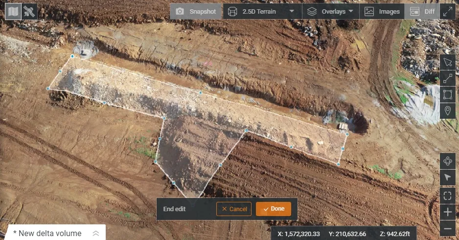
Features in the new update include the ability to provide measurements and analytics from design items, saving time, whether users are running calculations to compare design to the as-built for quality assurance or checking bills from subcontractors. The package can also eliminate any errors that might occur from manual drawing areas or lines. It can import images into HCSS Aerial to create a new annotation. The platform pins the annotation automatically, depending on the GPS position. Users inspecting a site on a tablet can import the photographs on the go. It offers easier drawing of lines and polygons for measurements and analytics.

Users can now make edits and adjust points in lines and polygons without starting calculations. The package can upload design files and notes before the first flight or while the flight is still being processed. A “Go to Coordinates” navigation tool can change a map display to a specific point by entering coordinates.

Measurement details for tablets optimises the small screen and allows users to choose between side navigation and a top-mounted calculation detail box.

For more information on companies in this article

Related Content

  • The use of concrete cutting tools and tips for users
    October 8, 2015
    Despite the proven importance of identifying metal targets and electrical lines before cutting into concrete, every day there are stories about mishaps that happen when the necessary reconnaissance is not done. In this article, a few firms that provide concrete scanning services weigh in on the critical importance of locating embedded and or buried obstructions by scanning for these features using ground penetrating radar (GPR). Also offered are tips for selecting the best GPR equipment and best practices f
  • Asphalt paving technology advance
    October 26, 2021
    Vögele is expanding its offering for digital road construction solutions with the introduction of new functions in its WITOS Paving Docu and WITOS Paving Plus packages
  • Bergkamp’s improved new slurry and seal paver
    February 27, 2017
    Bergkamp is introducing the M310CS truck-mounted slurry seal and micro surfacing paver, with power coming from its Tier 4 emissions compliant truck engine. With PTO-driven hydraulic pumps, the M310CS has eliminated the need for a side engine. This reduces exhaust emissions, noise and vibration while delivering power and performance equal to the side engine package that is standard on the M310 Paver. The M310CS is said to be productive and features the sophisticated electronic mix control and diagnostic (EMC
  • Michael Baker receives authority to fly unmanned aerial systems
    August 17, 2015
    US-based engineering firm Michael Baker International has received certification from the Federal Aviation Administration to operate several types of fixed-wing and vertical take-off and landing unmanned aircraft systems. The company said its UAS can capture robust, real-time aerial photographs and video as well as conduct aerial mapping for surveys or site inspections. "Integrating our FAA-certified unmanned aircraft program with our other advanced data collection capabilities allows us to take data