
Ireland and Scotland link?

Politicians in Northern Ireland have again raised the prospect of bridge to link western Scotland the Irish island, according to media reports. The road and rail crossing as envisaged by the Democratic Union Party would cost close to €23 billion. It would run between the Irish town of Larne in County Antrim and the Dumfries and Galloway coastline in Scotland. The DUP said in its manifesto for the 2015 UK general election that there should be a feasibility study into building a bridge or tunnel.
March 1, 2018 Read time: 3 mins
The Sweden-to-Denmark Oresund Bridge: a template for a Scotland-Ireland crossing? (photo: Drago Prvulovic)
Politicians in Northern Ireland have again raised the prospect of bridge to link western Scotland the Irish island, according to media reports.


The road and rail crossing as envisaged by the Democratic Union Party would cost close to €23 billion. It would run between the Irish town of Larne in County Antrim and the Dumfries and Galloway coastline in Scotland.

The DUP said in its manifesto for the 2015 UK general election that there should be a feasibility study into building a bridge or tunnel.

The party again suggested that a link be constructed after recent remarks by the UK’s foreign secretary Boris Johnson called for a cross-Channel bridge between England and France during a visit by French president Macron to London.

Alan Dunlop, one of Scotland’s leading urban architects, has been a staunch backer of a crossing. He was recently interviewed on a BBC Scotland radio programme where he again suggested it would bring “exceptional” business potential to Scotland as well as all Ireland.

Dunlop, who is also a professor of architecture at the UK’s Liverpool University, told The Times newspaper that a bridge could create a “Celtic powerhouse”.

However, a road bridge-tunnel might prove too costly and difficult to build, according to Ronnie Hunter of the UK’s 5180 Institution Of Civil Engineers. In an interview with the Scotsman newspaper in May 2016, he said a bridge would have to be multi-span and require dozens of piers across the channel.

“There are numerous bridges in North America built across relatively shallow water which go on as causeways for mile after mile. But we’re not talking about shallow water here - this is essentially next to the Atlantic Ocean, in very deep water,” he reportedly said. “The length suits a tunnel. It would likely have to be a rail tunnel, rather than a road tunnel, as it is hard to get the ventilation right.”

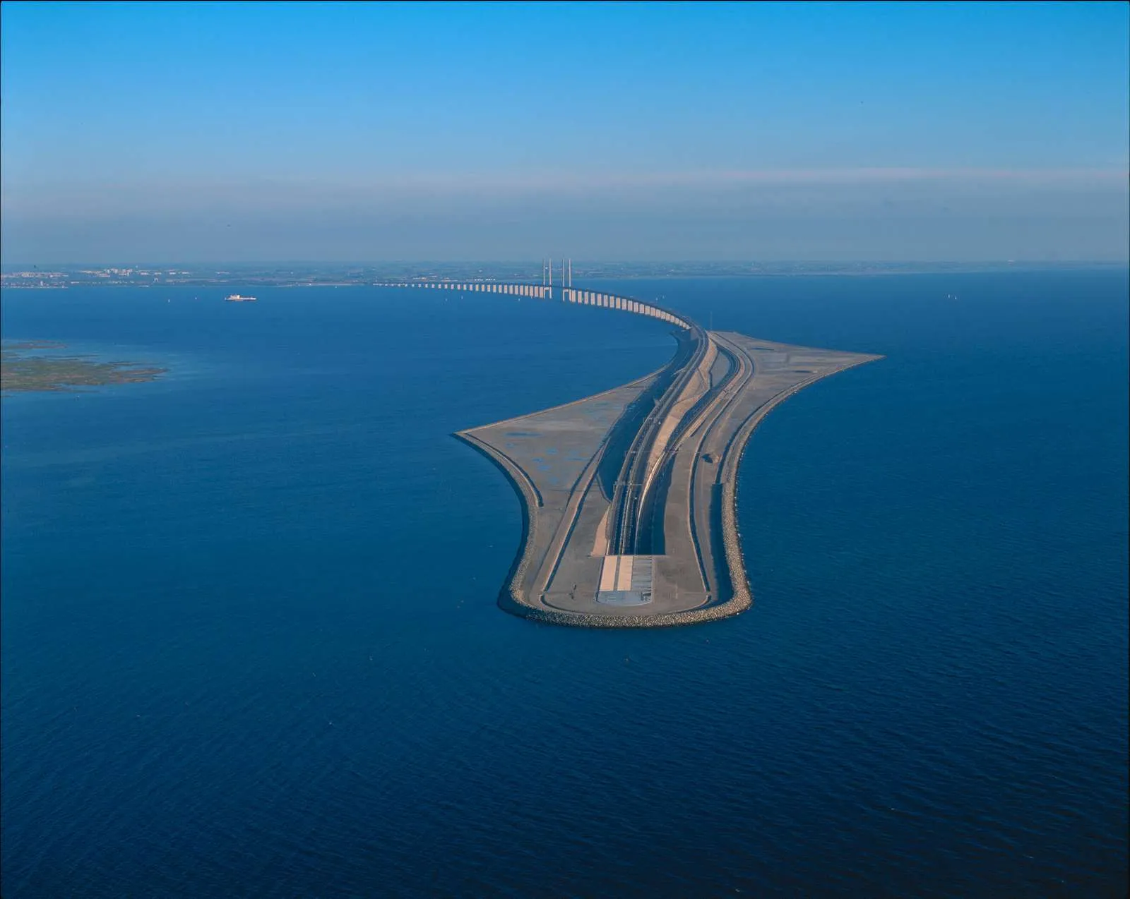
Even so, speculation has focused on a design similar to the rail and road one connecting Denmark and Sweden across the Oresund Strait. The bridge runs for 8km and the tunnel for 4km.

But any Ireland-Scotland crossing would have to navigate Beaufort’s Dyke, a  deep sea trench around 10km off the Scottish coast. Apart from its 300m depth, the trench was used as a dumping ground for unwanted conventional and chemical munitions after the end of the Second World War in 1945.

For more information on companies in this article

Related Content

  • Zipping up road lanes – with Barrier Systems
    September 10, 2018
    QMB has a Lindsay Road Zipper on duty near Montreal. World Highways deputy editor David Arminas climbed aboard As vice president of Canadian barrier specialist QMB, based in Laval, Quebec, Marc-Andre Seguin is sanguine about the future for moveable barriers. On the one hand, it looks good. The oft-stated advantage of moveable barriers is that the systems are cheaper to install than adding a lane or two to a highway or bridge. Directional changes to lanes can boost volume on a road without disrupting tra
  • Bluesky Aerial Mapping sees the trees and not the forest
    February 6, 2017
    Scientists at the University of Lancaster in England are using 3D data produced by Bluesky to refine a tree failure-risk model Pinpointing trees that might collapse onto roads and other infrastructure currently uses complex wind analysis techniques to assign a level of risk to individual trees. The data is Bluesky’s UK National Tree Map, laser mapped 3D height models, colour infrared (CIR) data and soil data. It will help identify individual trees and their proximity to roads as well as electricity insta
  • New Zezelj’s Bridge in Novi Sad symbolises brotherhood and unity
    September 7, 2018
    The new Bridge of Brotherhood and Unity, also known as Zezelj’s Bridge, across the Danube River in Novi Sad, Serbia, is officially open. The road and rail tied-arch bridge replaces the original bridge of the same name that was built in 1961, named after the designer Branko Zezelj. The designer of the new bridge is Aleksandar Bojović and the contractor was an international consortium of Azvi, Taddei and Horta Coslada. One of the two arches is 177m long and 34m high and the other is 219m long and 42m high.
  • Bomag’s president Ralf Junker puts his faith in BIM
    November 8, 2017
    World Highways recently caught up with Ralf Junker, president of BOMAG Group, during the company’s Innovation Days at its headquarters in Germany. David Arminas reports. Ralf Junker hasn’t forgotten his roots. You can put as much machine control as you like on a piece of construction equipment but all that high-technology is for nothing if the build quality isn’t there. Junker knows something about build quality. When he started at BOMAG in 1988, he was in the welding shop, eventually becoming supervisor