When it comes to runways, there are few busier then Brisbane’s main runway. Servicing both domestic and international travel, with over 200,000 movements per year, operating without a curfew Brisbane’s main runway is the busiest in Australia. For maintenance, crews only have a limited period of time to determine the pavement condition, normally during the night, making the detection of pavement faults difficult. To resolve this issue, a new high speed pavement scanner was used to rapidly survey the pavem
When it comes to runways, there are few busier then Brisbane’s main runway. Servicing both domestic and international travel, with over 200,000 movements per year, operating without a curfew Brisbane’s main runway is the busiest in Australia. For maintenance, crews only have a limited period of time to determine the pavement condition, normally during the night, making the detection of pavement faults difficult. To resolve this issue, a new high speed pavement scanner was used to rapidly survey the pavement condition. In less than 4 hours, the entire runway pavement was surveyed for cracking, rutting, roughness and groove closure. The results available a few weeks later was detailed pavement knowledge to allow assessment and planning, while maintaining zero runway downtime.
Airport runways across the world are increasing under pressure. Since the 1980’s aircraft have grown in size, with tyre pressures increasing, and wheel loadings of over 60,000 pounds, around twice what it was pre 1980. The number of movements and volume of passengers has also increased. For an aircraft pavement the result is higher and more frequent loadings, increased pavement damage and reduced pavement life. At the same time, there are reduced time windows to access and maintain the pavement.
Most runway assessments are manual and time consuming. While it can be done accurately with the right tools, it requires time on the pavement, expert knowledge, thorough systems, good positioning techniques and enough light to see clearly. If working on a live runway there are safety issues and associated stress on staff. As an example, a recent cracking mapping survey of a runway in the USA, took around 2 months for a team of 6 graduate engineers to complete, working in daylight hours. For most runways, this period of downtime would be unacceptable, even if you have an inexhaustible supply of graduate engineers.
This dilemma was clear to Stuart Wise, Civil Asset Manager at5228 Brisbane Airport Corporation. In his view, “the use of new generation technology in the assessment of aircraft pavement condition will become increasingly important in coming years, in particular for Runway Pavements.” There really is no other better way to obtain the information for pavement management, while simultaneously dramatically reducing the time spent on the runway.
For the Brisbane Airport Corporation (BAC) the solution has been working with a local Australian company,6830 Radar Portal Systems (RPS), to develop and test technology for rapid and accurate runway pavement assessment. For runway asset managers there are three main areas of concern: surface integrity (including cracking, stone loss, groove damage, stripping and permeability), surface shape (Boeing Bump Index, Ride Quality, Rutting and Surface Drainage), and surface friction (ICAO compliance and surface texture).
Radar Portal Systems is a technology development company, focusing on solutions for the road pavement industry. They have developed a range of innovative technologies, ranging from high speed 3D Ground Penetrating Radar (GPR), to highly detailed structured light imaging and high speed laser profiling. While the technology has primarily been developed for surface and subsurface condition assessment for the road pavements, it has also being applied to a number of different markets, including the assessment of airport runways and taxiways.
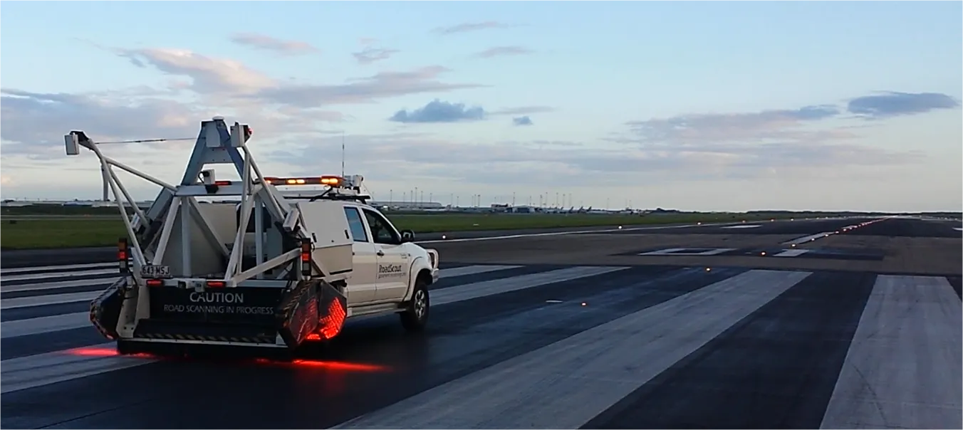
The RoadScout system is a multipurpose surface and subsurface imaging platform, mounted to a pickup vehicle. The system allows the simultaneous capture of a range of pavement distress features, through a suite of sensors, at speeds of up to 100km/h. These include optical imaging, laser profiling, GPS, inertial sensors, point lasers and environmental cameras. For the Brisbane airport, an agricultural guidance system was also utilised to ensure that full surface coverage was achieved for the runway and allowed for accurate 2 metre spaced runs along the 45 meter wide pavement. The survey of the runway took around 4 hours in Total, and involved driving up and down the runway 23 times, at different offsets from the centre line. If pavement depth or subsurface cracking was also required, RPS’s 3D GPR trailer could have also been used on the same vehicle platform.
The surface cracking on the pavement was determined using a patented new technique of photometric stereo surface imaging. This world first imaging system uses four banks of artificial lighting, each which is 30 times more powerful then sunlight, to illuminate the pavement surface from four different directions. These lighting banks are flashed at up to 60,000 times per second, allowing collection of four simultaneous images of the surface, with different lightings conditions. This technology makes it not only possible to produce detailed images of the surface, but also simultaneously allows separation of the structure of the surface, from surface shading and colour. The result is an ultra-high resolution topography mapping system, with a grid resolution of one millimetre square, which is then used to detect and geospatially map the cracking in the runway surface.
The conventional method of surveying the surface shape of an airport is to use a laser based total station to measure the surface profile. This is a laborious, expensive and difficult task to perform accurately. As a result, this is normally only done as part of the initial compliance test of the runway after construction. Alternatively, current laser scanning systems, or point cloud systems, could be considered. However due to multi errors, they are almost always inadequate for runway surveys. Firstly, the distance measurement accuracy of a point cloud system is normally no better than 5mm, below the required accuracy of rut estimation. This is further reduced when imaging off a dark runway surface, which is also grooved. Even if accurate measurements could be achieved, the usual vehicle positioning system doesn’t achieve the required short term positioning accuracy, due to the standard methods used to combine GPS and Inertial Measurement Unit (IMU) measurements. As a result run mesh collection is normally not done on a regular basis.
To accurately position measurements, the RoadScout system uses a reference station corrected GPS combined with a laser based Inertial Measurement Unit (IMU). As an airport always has an unobstructed surface with respect to satellite coverage, high accuracy centimetre GPS positioning accuracy is achievable for the entire pavement. When this is combined with the IMU measurement, the accuracy is sufficient to determine Boeing Bump Index (BBI) measurements, with the IMU measurements removing short term GPS errors.
For the airport surface, the laser profiling system was used for determining both the surface contour and the rut measurements. As part of a normal survey, the RoadScout system produces a high density 2048 point profile of the surface over a 4 meter width every 60mm of travel. The system has much higher accuracy then a point cloud laser scanning system, with a height accuracy of +/-0.1mm. For conventional road pavement analysis, a 2 or 3 meter straight edge or taught wire would be used. For an airport, as an aircraft has a wider wheelbase, it was instead recommended by BAC to use a 15 meter taught wire applied across the runway. To achieve this multiple profiles were stitched together to produce a single profile of the entire runway. Initially the GPS/IMU system was used to accurately place these profiles in the right location. GPS however, with the typical height errors in such a system, it was not accurate enough to produce a height profile. Instead the overlapping zones between the profiles were used, matching profiles together to produce a wider total profile.
The final measurement required as part of the survey was the measurement of runway surface groove closure. As part of a runway construction, grooves are cut into the pavement to improve wet weather surface friction. These grooves can wear down, or fold over, resulting in areas of reduced grip. This is especially true at taxiway intersections which connect to the main runway where extreme loads and pressures are regularly applied to the pavement by departing aircraft.
As part of the assessment, field calibration was performed to prove the accuracy of the measurements. During this process RPS personnel experienced first-hand the torture of manual assessment in the field. To simply collect reference results which represented around 0.0001% of the data collected by the system within the 3 hours of scanning, took two full nights of total station surveying of the pavement: with all the associated joy of being eaten alive by mosquitoes, 8 total station setups and around 20 kilometres of walking. Thankfully, field calibration is not required as part of a normal RPS runway survey!
From BAC’s perspective, Stuart Wise indicated that “the graphical display of the runway condition was of great benefit in clarifying the observations made onsite during our brief periods of manual inspection. It gave evidence to assist our decision to proceed with our runway overlay to the ends of the runway and defer the central portion based as it was in far better condition.”
“Brisbane Airport’s main runway carries 93-95% of all movements with the smaller cross runway only capable of carrying Code C aircraft. The ultimate solution is a new parallel runway capable of taking Code F aircraft which will allow much greater flexibility to undertake maintenance activities. Whilst work is now underway, the dredging and site reclamation stage is expected to take 4 years and final completion is not due until 2020. This means there will be six more years of growth in movement to accommodate before relief. This new technology will become invaluable. The repeatability allowing comparison between surveys to determine deterioration and completed work is of great use. But the speed at which the data is acquired and the ability for it to be analysed safely and thoroughly in a stress free office environment is the real advantage of applying the technology to a runway.”
BAC is now looking to trial the survey of concrete taxiways with the Roadscout and RPS high-speed Noise Modulated Ground Penetrating Radar (NM-GPR) to capture both surface and sub-surface conditions in order to improve asset management.
Contact Due to the increasing interest and utilisation of its technology, Radar Portal Systems is restructuring into two entities: R&D will focus on technology innovation and new product development, whilst operations will focus on increasing its penetration into the domestic and international markets for service provision and machine sales. If you have any interest in RPS, please contact Nige Austin +61 7 3376 2453 or %$Linker:2 Email <?xml version="1.0" encoding="utf-16"?><dictionary /> 0 0 0 oLinkEmail [email protected] Email: [email protected] false mailto:[email protected] true false %>
Airport runways across the world are increasing under pressure. Since the 1980’s aircraft have grown in size, with tyre pressures increasing, and wheel loadings of over 60,000 pounds, around twice what it was pre 1980. The number of movements and volume of passengers has also increased. For an aircraft pavement the result is higher and more frequent loadings, increased pavement damage and reduced pavement life. At the same time, there are reduced time windows to access and maintain the pavement.
Most runway assessments are manual and time consuming. While it can be done accurately with the right tools, it requires time on the pavement, expert knowledge, thorough systems, good positioning techniques and enough light to see clearly. If working on a live runway there are safety issues and associated stress on staff. As an example, a recent cracking mapping survey of a runway in the USA, took around 2 months for a team of 6 graduate engineers to complete, working in daylight hours. For most runways, this period of downtime would be unacceptable, even if you have an inexhaustible supply of graduate engineers.
This dilemma was clear to Stuart Wise, Civil Asset Manager at
For the Brisbane Airport Corporation (BAC) the solution has been working with a local Australian company,
Radar Portal Systems is a technology development company, focusing on solutions for the road pavement industry. They have developed a range of innovative technologies, ranging from high speed 3D Ground Penetrating Radar (GPR), to highly detailed structured light imaging and high speed laser profiling. While the technology has primarily been developed for surface and subsurface condition assessment for the road pavements, it has also being applied to a number of different markets, including the assessment of airport runways and taxiways.
The RoadScout system is a multipurpose surface and subsurface imaging platform, mounted to a pickup vehicle. The system allows the simultaneous capture of a range of pavement distress features, through a suite of sensors, at speeds of up to 100km/h. These include optical imaging, laser profiling, GPS, inertial sensors, point lasers and environmental cameras. For the Brisbane airport, an agricultural guidance system was also utilised to ensure that full surface coverage was achieved for the runway and allowed for accurate 2 metre spaced runs along the 45 meter wide pavement. The survey of the runway took around 4 hours in Total, and involved driving up and down the runway 23 times, at different offsets from the centre line. If pavement depth or subsurface cracking was also required, RPS’s 3D GPR trailer could have also been used on the same vehicle platform.
The surface cracking on the pavement was determined using a patented new technique of photometric stereo surface imaging. This world first imaging system uses four banks of artificial lighting, each which is 30 times more powerful then sunlight, to illuminate the pavement surface from four different directions. These lighting banks are flashed at up to 60,000 times per second, allowing collection of four simultaneous images of the surface, with different lightings conditions. This technology makes it not only possible to produce detailed images of the surface, but also simultaneously allows separation of the structure of the surface, from surface shading and colour. The result is an ultra-high resolution topography mapping system, with a grid resolution of one millimetre square, which is then used to detect and geospatially map the cracking in the runway surface.
The conventional method of surveying the surface shape of an airport is to use a laser based total station to measure the surface profile. This is a laborious, expensive and difficult task to perform accurately. As a result, this is normally only done as part of the initial compliance test of the runway after construction. Alternatively, current laser scanning systems, or point cloud systems, could be considered. However due to multi errors, they are almost always inadequate for runway surveys. Firstly, the distance measurement accuracy of a point cloud system is normally no better than 5mm, below the required accuracy of rut estimation. This is further reduced when imaging off a dark runway surface, which is also grooved. Even if accurate measurements could be achieved, the usual vehicle positioning system doesn’t achieve the required short term positioning accuracy, due to the standard methods used to combine GPS and Inertial Measurement Unit (IMU) measurements. As a result run mesh collection is normally not done on a regular basis.
To accurately position measurements, the RoadScout system uses a reference station corrected GPS combined with a laser based Inertial Measurement Unit (IMU). As an airport always has an unobstructed surface with respect to satellite coverage, high accuracy centimetre GPS positioning accuracy is achievable for the entire pavement. When this is combined with the IMU measurement, the accuracy is sufficient to determine Boeing Bump Index (BBI) measurements, with the IMU measurements removing short term GPS errors.
For the airport surface, the laser profiling system was used for determining both the surface contour and the rut measurements. As part of a normal survey, the RoadScout system produces a high density 2048 point profile of the surface over a 4 meter width every 60mm of travel. The system has much higher accuracy then a point cloud laser scanning system, with a height accuracy of +/-0.1mm. For conventional road pavement analysis, a 2 or 3 meter straight edge or taught wire would be used. For an airport, as an aircraft has a wider wheelbase, it was instead recommended by BAC to use a 15 meter taught wire applied across the runway. To achieve this multiple profiles were stitched together to produce a single profile of the entire runway. Initially the GPS/IMU system was used to accurately place these profiles in the right location. GPS however, with the typical height errors in such a system, it was not accurate enough to produce a height profile. Instead the overlapping zones between the profiles were used, matching profiles together to produce a wider total profile.
The final measurement required as part of the survey was the measurement of runway surface groove closure. As part of a runway construction, grooves are cut into the pavement to improve wet weather surface friction. These grooves can wear down, or fold over, resulting in areas of reduced grip. This is especially true at taxiway intersections which connect to the main runway where extreme loads and pressures are regularly applied to the pavement by departing aircraft.
As part of the assessment, field calibration was performed to prove the accuracy of the measurements. During this process RPS personnel experienced first-hand the torture of manual assessment in the field. To simply collect reference results which represented around 0.0001% of the data collected by the system within the 3 hours of scanning, took two full nights of total station surveying of the pavement: with all the associated joy of being eaten alive by mosquitoes, 8 total station setups and around 20 kilometres of walking. Thankfully, field calibration is not required as part of a normal RPS runway survey!
From BAC’s perspective, Stuart Wise indicated that “the graphical display of the runway condition was of great benefit in clarifying the observations made onsite during our brief periods of manual inspection. It gave evidence to assist our decision to proceed with our runway overlay to the ends of the runway and defer the central portion based as it was in far better condition.”
“Brisbane Airport’s main runway carries 93-95% of all movements with the smaller cross runway only capable of carrying Code C aircraft. The ultimate solution is a new parallel runway capable of taking Code F aircraft which will allow much greater flexibility to undertake maintenance activities. Whilst work is now underway, the dredging and site reclamation stage is expected to take 4 years and final completion is not due until 2020. This means there will be six more years of growth in movement to accommodate before relief. This new technology will become invaluable. The repeatability allowing comparison between surveys to determine deterioration and completed work is of great use. But the speed at which the data is acquired and the ability for it to be analysed safely and thoroughly in a stress free office environment is the real advantage of applying the technology to a runway.”
BAC is now looking to trial the survey of concrete taxiways with the Roadscout and RPS high-speed Noise Modulated Ground Penetrating Radar (NM-GPR) to capture both surface and sub-surface conditions in order to improve asset management.
Contact Due to the increasing interest and utilisation of its technology, Radar Portal Systems is restructuring into two entities: R&D will focus on technology innovation and new product development, whilst operations will focus on increasing its penetration into the domestic and international markets for service provision and machine sales. If you have any interest in RPS, please contact Nige Austin +61 7 3376 2453 or %$Linker: