Spot on with Trimble’s X7 3D scanner

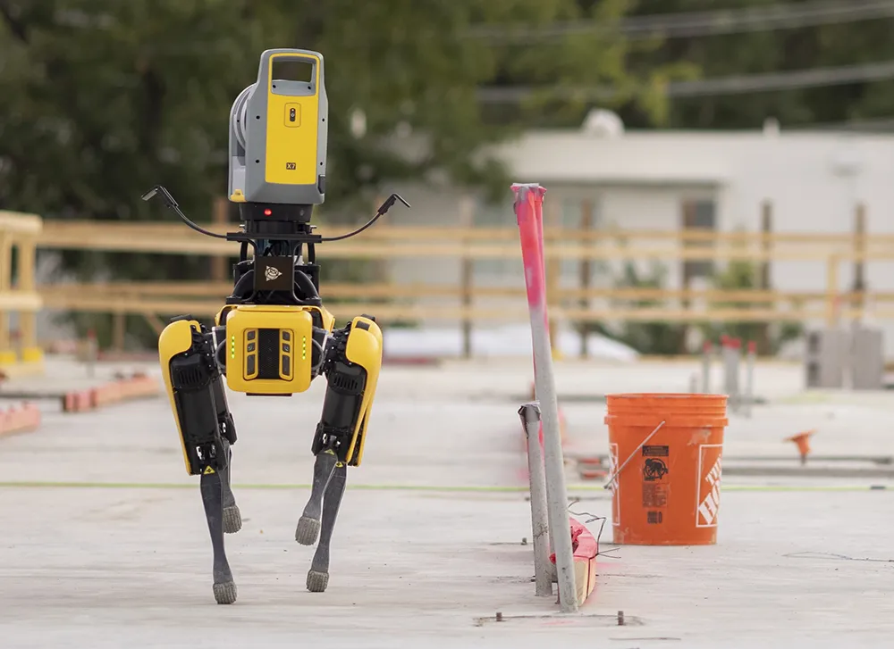
The X7 solution was jointly developed by Trimble and Boston Dynamics.
By Mike Woof November 25, 2021 Read time: 2 mins
Autonomous surveying and scanning is possible using the new package from Trimble

Remote surveying and scanning can be achieved using the autonomous robotic system available from Trimble. The package combines the Spot robot autonomous rover unit with the Trimble X7 3D laser scanner and Trimble FieldLink software.

This solution has been jointly developed between Trimble and Boston Dynamics and allows autonomous operation on construction sites. The system takes advantage of the robot's ability to navigate challenging, dynamic and potentially unsafe environments. Trimble's 3D data capture technology can deliver a continuous flow of information between the field and the office for documentation of jobsite progress.

The innovative package allows users to make important decisions, rather than waiting for the information to be relayed to project staff. The integration is focused on the automated capture of field construction data through the use of Trimble 3D capture technology and the Spot robot. The autonomous workflow for the X7 laser scanner uses fully integrated Spot robot controls in FieldLink software to create a predefined path of waypoints for Spot to follow and collect laser scans.

Laser scans collected using the X7 scanner and the Spot robot can be tied to a jobsite project coordinate system, as well as individual scan stations. The data is collected, and then made into a composite point cloud in real-time on the Trimble tablet controller before leaving the site. While performing autonomous operations, Spot's docking station enables in-field charging of batteries on both the robot and the X7 3D laser scanner, and also provides the continuous transfer of data through a Gigabit Ethernet connection to the office.

For more information on companies in this article

Related Content

  • Topcon and Bentley: integration between MAGNET 4.0 and ProjectWise
    June 7, 2016
    Topcon Positioning Group and Bentley Systems have set up direct communication between Bentley’s design applications and Topcon mobile work force products with the upcoming MAGNET 4.0 release. With the direct communication from MAGNET Enterprise to Bentley’s ProjectWise, users of Topcon’s family of MAGNET and 3D-MC software solutions can now, while working in the field, access or receive i-models created by Bentley’s OpenRoads design modeling technology. By the end of June, survey data and as-built
  • Growing WIM demand in Russia and South America
    April 4, 2014
    One Eastern European WIM manufacturer is finding commercial success in Russia, while another leading manufacturer is in demand in South America, as Guy Woodford reports Since Czech WIM technology manufacturer Camea secured type approval for its UnicamWIM system in early 2013, the firm has been installing a number of the systems in different Russian regions. These have included two UnicamWIM stations in Novosibirsk, one in the Kostroma region, and another on the M20 Highway between Belarus and Russia.
  • MOBA’s mobile automation solutions at Conexpo
    January 6, 2017
    MOBA’s new PAVE-IR Scan system offers a new way of monitoring and documenting the temperature during asphalt paving for an entire project. As a result, contractors can optimise their work and verify the quality of the paving process. With the system’s intelligent temperature scanner, the system measures the asphalt temperature over the whole paving width of up to eight metres. The temperature profile is displayed in real-time on the display and the operator can react at any time if irregularities occur. All
  • MOBA’s mobile automation solutions at Conexpo
    January 17, 2014
    MOBA’s new PAVE-IR Scan system offers a new way of monitoring and documenting the temperature during asphalt paving for an entire project. As a result, contractors can optimise their work and verify the quality of the paving process. With the system’s intelligent temperature scanner, the system measures the asphalt temperature over the whole paving width of up to eight metres. The temperature profile is displayed in real-time on the display and the operator can react at any time if irregularities occur. All