Spot on with Trimble’s X7 3D scanner

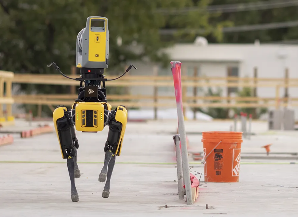
The X7 solution was jointly developed by Trimble and Boston Dynamics.
By Mike Woof November 25, 2021 Read time: 2 mins
Autonomous surveying and scanning is possible using the new package from Trimble

Remote surveying and scanning can be achieved using the autonomous robotic system available from Trimble. The package combines the Spot robot autonomous rover unit with the Trimble X7 3D laser scanner and Trimble FieldLink software.

This solution has been jointly developed between Trimble and Boston Dynamics and allows autonomous operation on construction sites. The system takes advantage of the robot's ability to navigate challenging, dynamic and potentially unsafe environments. Trimble's 3D data capture technology can deliver a continuous flow of information between the field and the office for documentation of jobsite progress.

The innovative package allows users to make important decisions, rather than waiting for the information to be relayed to project staff. The integration is focused on the automated capture of field construction data through the use of Trimble 3D capture technology and the Spot robot. The autonomous workflow for the X7 laser scanner uses fully integrated Spot robot controls in FieldLink software to create a predefined path of waypoints for Spot to follow and collect laser scans.

Laser scans collected using the X7 scanner and the Spot robot can be tied to a jobsite project coordinate system, as well as individual scan stations. The data is collected, and then made into a composite point cloud in real-time on the Trimble tablet controller before leaving the site. While performing autonomous operations, Spot's docking station enables in-field charging of batteries on both the robot and the X7 3D laser scanner, and also provides the continuous transfer of data through a Gigabit Ethernet connection to the office.

For more information on companies in this article

Related Content

  • Low temperature asphalt and aggregate options’
    February 7, 2014
    At what point does ‘some technology’ become ‘enough technology’? Less than four years ago industry publications were filled with a persistent message, the reluctance of UK based contractors to adopt machine control to the same extent as near European neighbours, particularly close ones such as Ireland and Holland. However from 2009 onwards we have seen a huge shift in demand for machine control as the success of high profile road and rail jobs such as the M25 widening scheme and Airdrie – Bathgate rail
  • Software collaboration between Autodesk and Leica Geosystems
    October 8, 2019
    Leica Geosystems has announced further cooperation with Autodesk to streamline construction documentation.
  • Take the lead in milling
    April 30, 2024
    Being an early adopter of machine control systems has been a benefit for a US contractor.
  • Bentley Systems boosting business with acquisition
    February 11, 2015
    Construction software specialist Bentley Systems continues to develop its portfolio of solutions with yet another acquisition. The company is growing both organically and through acquisition, this time buying up the French firm Acute3D, provider of Smart3DCapture software for reality modelling. Through reality modelling, observations of existing conditions can be processed into representations for contextual alignment within design modelling and construction modelling environments. According to Bentley, rap