Sophisticated surveying tool from Topcon

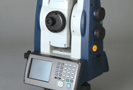
Topcon Postioning is now offering a sophisticated surveying tool in the shape of an auto-collimating total station for surveying professionals looking for a motorised solution. The firm says that this rugged waterproof total station benefits from the latest TSshield technology for advanced security and maintenance. The system can also be upgraded to Autotracking when the customer is ready to advance further to robotic applications. The GT-503M can be used for Tunnel Guidance and Periodic Monitoring applicat
September 4, 2019 Read time: 2 mins
342 Topcon Postioning is now offering a sophisticated surveying tool in the shape of an auto-collimating total station for surveying professionals looking for a motorised solution. The firm says that this rugged waterproof total station benefits from the latest TSshield technology for advanced security and maintenance. The system can also be upgraded to Autotracking when the customer is ready to advance further to robotic applications. The GT-503M can be used for Tunnel Guidance and Periodic Monitoring applications.


Key features include direct drive motors capable of turning 85°, in a small and lightweight package that is auto-collimating. This also features the LongLink Communications system with a range of 300m, advanced angle accuracy and the TSshield advanced security and maintenance package. The system offers an 800m non-prism range and a 4,500m prism range, as well as a laser pointer and sunlight readable display.

The new dual SIM module allows the customer to insert their own data SIM card in the GT-503M total station to communicate directly to MAGNET Enterprise. The telematics card installed can communicate to the TSshield servers, which can then review if the total station has any existing error codes, the version of the firmware that is installed, as well as the total station geographical location. From this information, a message can be sent to the total station and advise the operator if further action is available or necessary. The new dual SIM module allows the customer to insert their own data SIM card in the GT-503M total station for real-time site communications.

The GT-503M can find a prism and lock within the field of view simplifying the steps for the operator to find the prism. There is no need to focus the GT-503M to find the prism.

For more information on companies in this article

Related Content

  • Machine control advances boosting quality
    June 12, 2017
    The latest developments in machine control technology will deliver major gains in quality and productivity. Machine control technology plays an increasingly important role in construction. The pace of development has been fast, with new systems offering major gains in both productivity and quality across a range of applications. At the recent CONEXPO-CON/AGG 2017 exhibition in Las Vegas, key advances were unveiled in machine control technologies suited to markets such as earthmoving, concrete paving and pil
  • Sokkia’s “redefinition of robotics”
    December 20, 2012
    Sokkia has unveiled what it describes as “redefinition of robotics” with its SX series of total stations. The SX series are said to be compact and lightweight systems containing the most modern technology available. Sokkia says the SX’s high-accuracy robotic technology includes an advanced angle measurement system, RED-tech technology, reflectorless EDM, Bluetooth Class 1 long-range data communication, and what is said to be an extremely accurate auto-tracking system using RC-PR5 remote control. Combining t
  • Sophisticated geopositioning tool from Topcon
    October 9, 2018
    Topcon says that its new T-18 handheld controller offers accuracy for geopositioning, construction, mapping and vertical construction applications. The controller includes a sunlight-readable display with a 1GHz processor, 1GB of internal storage, and up to 10 hours of battery life. “For MAGNET Field data collection, the T-18 controller offers a durable ergonomic solution with faster processing, a larger screen, better connectivity and longer battery life than previously available comparable systems,” said
  • Wider range of survey software functionality
    February 9, 2012
    Leica Geosystems is offering a broad spread of new packages and hardware that will deliver improved performance to users. The firmware 2.0 product is said to add powerful new capabilities to the Leica ScanStation C10, the industry's most popular 3D laser scanner for as-built and topographic surveys. This further increases the productivity and versatility of the fully integrated, cable-less ScanStation C10. A new Setup facility lets users take advantage of known survey points and backsighting, while remote,