
Sophisticated surveying tool from Topcon

Topcon Postioning is now offering a sophisticated surveying tool in the shape of an auto-collimating total station for surveying professionals looking for a motorised solution. The firm says that this rugged waterproof total station benefits from the latest TSshield technology for advanced security and maintenance. The system can also be upgraded to Autotracking when the customer is ready to advance further to robotic applications. The GT-503M can be used for Tunnel Guidance and Periodic Monitoring applicat
September 4, 2019 Read time: 2 mins
342 Topcon Postioning is now offering a sophisticated surveying tool in the shape of an auto-collimating total station for surveying professionals looking for a motorised solution. The firm says that this rugged waterproof total station benefits from the latest TSshield technology for advanced security and maintenance. The system can also be upgraded to Autotracking when the customer is ready to advance further to robotic applications. The GT-503M can be used for Tunnel Guidance and Periodic Monitoring applications.


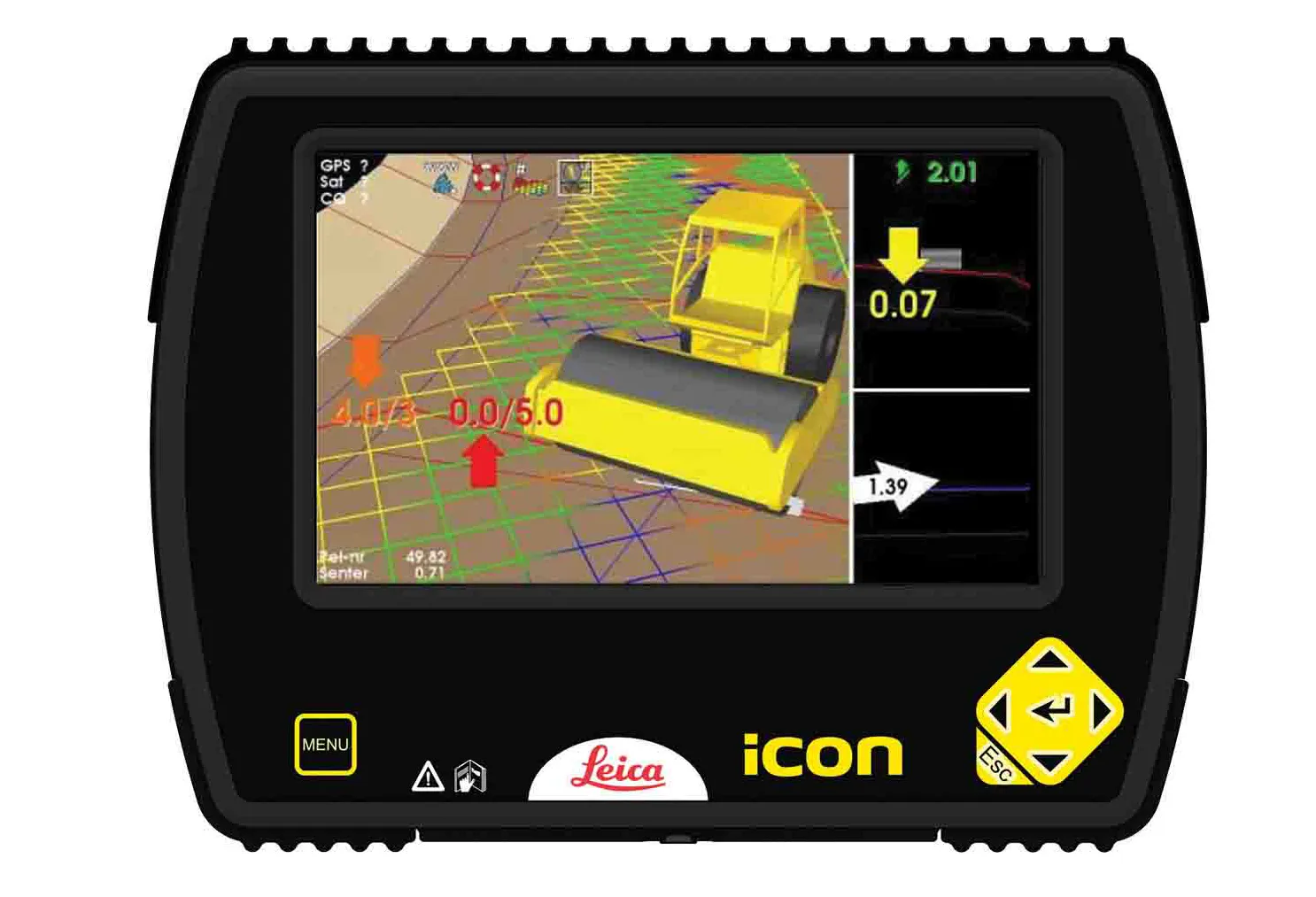
Key features include direct drive motors capable of turning 85°, in a small and lightweight package that is auto-collimating. This also features the LongLink Communications system with a range of 300m, advanced angle accuracy and the TSshield advanced security and maintenance package. The system offers an 800m non-prism range and a 4,500m prism range, as well as a laser pointer and sunlight readable display.

The new dual SIM module allows the customer to insert their own data SIM card in the GT-503M total station to communicate directly to MAGNET Enterprise. The telematics card installed can communicate to the TSshield servers, which can then review if the total station has any existing error codes, the version of the firmware that is installed, as well as the total station geographical location. From this information, a message can be sent to the total station and advise the operator if further action is available or necessary. The new dual SIM module allows the customer to insert their own data SIM card in the GT-503M total station for real-time site communications.

The GT-503M can find a prism and lock within the field of view simplifying the steps for the operator to find the prism. There is no need to focus the GT-503M to find the prism.

For more information on companies in this article

Related Content

  • Leica Geosystems offers smart compaction tool
    January 12, 2017
    Leica Geosystems is now offering a sophisticated machine control tool for use with compaction equipment. The firm’s advanced iCON roller package is said to offer contractors an effective solution that can deliver constant and effective compaction on any site. The new iCON roller has on-screen visualisation to show the user where completed passes have occurred and where more are needed for consistent results. Colour coding helps avoid costly reworking as pass count progress is constantly tracked. The unit
  • Innovative concrete paving technology is coming to market
    March 12, 2014
    Two of the leaders in the concrete paving sector are broadening their range of technology, with new systems now coming to the international market The concrete paving market is a niche segment of the construction equipment business, with only a few specialist firms competing. North America is the home of concrete slipforming technology and it is no surprise that all but one of the leading firms in the sector are based in the US. The technology is used worldwide however and with asphalt prices at a high, c
  • Efficient asset management delivers
    April 25, 2013
    Maximising the economic benefit of infrastructure assets can be achieved through delivering better quality maintenance. Increasing utilisation of infrastructure follows on from those assets being in better condition. Clearly by tracking infrastructure condition closely, huge gains can be made in addressing technical issues before they become more serious and more costly, as well as minimising disruption. In UK city Birmingham, high resolution aerial photography from Bluesky is helping the city council under
  • Sophisticated GNSS system
    February 9, 2012
    Leica Geosystems says that its new GR10 unit is a sophisticated GNSS reference station receiver and features ease of use, reliability and performance. The GR10 is said to help streamline system installation, day to day operation and administration. The system can be commissioned quickly and features its own receiver hostname while DHCP support means there is no need for pre-configuration of the IP address.