Sophisticated geopositioning tool from Topcon

Topcon says that its new T-18 handheld controller offers accuracy for geopositioning, construction, mapping and vertical construction applications. The controller includes a sunlight-readable display with a 1GHz processor, 1GB of internal storage, and up to 10 hours of battery life. “For MAGNET Field data collection, the T-18 controller offers a durable ergonomic solution with faster processing, a larger screen, better connectivity and longer battery life than previously available comparable systems,” said
October 9, 2018 Read time: 2 mins
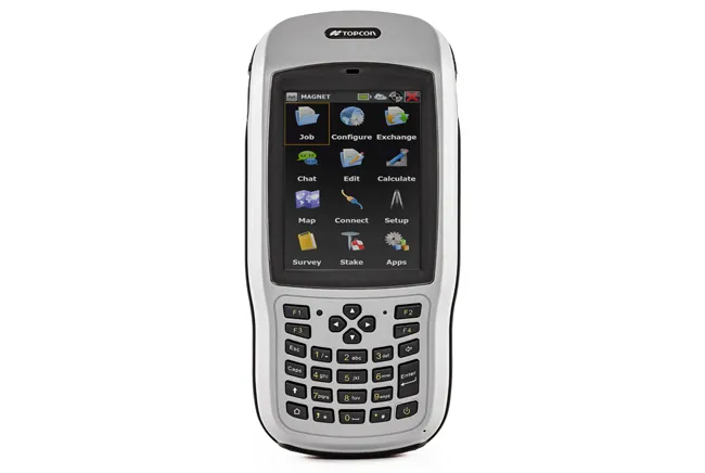
Topcon’s new T-18 unit offers advanced geopositioning capabilities
342 Topcon says that its new T-18 handheld controller offers accuracy for geopositioning, construction, mapping and vertical construction applications.  The controller includes a sunlight-readable display with a 1GHz processor, 1GB of internal storage, and up to 10 hours of battery life. “For MAGNET Field data collection, the T-18 controller offers a durable ergonomic solution with faster processing, a larger screen, better connectivity and longer battery life than previously available comparable systems,” said Ray Kerwin, director of global surveying products.


The T-18 features a 3.5G cellular modem for connectivity with Topcon MAGNET solutions for sending and receiving data to the cloud company account.  The firm says that the cellular option makes it easier to communicate with field crews when projects need to be changed or if important data is required back in the office. The modem can be used for RTK correction services. Additional key features include standard Bluetooth and Wi-Fi connectivity, as well as an IP65 rating for dust and water protection in demanding job site conditions.

For more information on companies in this article

Related Content

  • Surveying software
    February 6, 2012
    A new CAD-based package is available for surveying and job site information editing and plotting from Topcon Europe Positioning. Called SurveyMaster Lite, this software is a cost-efficient surveying office package suited to cadastral surveying and construction stakeout duties. The product has been developed from Topcon's SurveyMaster software program, SurveyMaster Lite and features survey specific
  • SWARCO prism signs for Highways England
    September 8, 2020
    The deal is part of a phased scheme of a diversion routes over the next few years.
  • Sophisticated weighing for loaders
    January 28, 2014
    Sophisticated on-board weighing systems for use with wheeled loaders and excavators are being offered by Loup Electronics. The innovative LOADEX 100 is a retrofittable scale installed on tracked and wheeled excavators and material handlers to weigh the amount of material load in the bucket or grab. Pressure signals are captured, filtered and corrected by measuring the angle of the main boom using either an RDS Inclinometer or Mechanical Angle sensor. When used dynamically, the pressures are captured through
  • Brisbane’s Airport: Innovative Management of One of the World’s Busiest Runways
    June 26, 2014
    When it comes to runways, there are few busier then Brisbane’s main runway. Servicing both domestic and international travel, with over 200,000 movements per year, operating without a curfew Brisbane’s main runway is the busiest in Australia. For maintenance, crews only have a limited period of time to determine the pavement condition, normally during the night, making the detection of pavement faults difficult. To resolve this issue, a new high speed pavement scanner was used to rapidly survey the pavem