Sophisticated geopositioning tool from Topcon

Topcon says that its new T-18 handheld controller offers accuracy for geopositioning, construction, mapping and vertical construction applications. The controller includes a sunlight-readable display with a 1GHz processor, 1GB of internal storage, and up to 10 hours of battery life. “For MAGNET Field data collection, the T-18 controller offers a durable ergonomic solution with faster processing, a larger screen, better connectivity and longer battery life than previously available comparable systems,” said
October 9, 2018 Read time: 2 mins
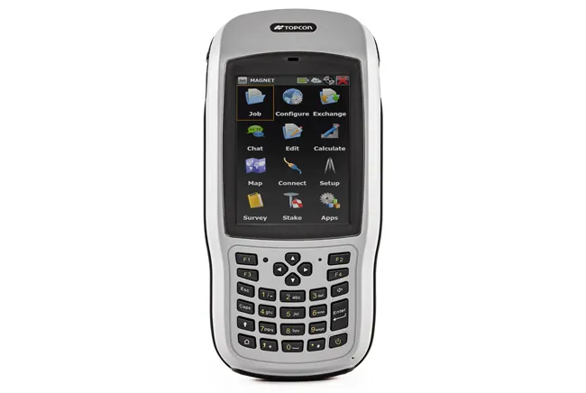
Topcon’s new T-18 unit offers advanced geopositioning capabilities
342 Topcon says that its new T-18 handheld controller offers accuracy for geopositioning, construction, mapping and vertical construction applications.  The controller includes a sunlight-readable display with a 1GHz processor, 1GB of internal storage, and up to 10 hours of battery life. “For MAGNET Field data collection, the T-18 controller offers a durable ergonomic solution with faster processing, a larger screen, better connectivity and longer battery life than previously available comparable systems,” said Ray Kerwin, director of global surveying products.


The T-18 features a 3.5G cellular modem for connectivity with Topcon MAGNET solutions for sending and receiving data to the cloud company account.  The firm says that the cellular option makes it easier to communicate with field crews when projects need to be changed or if important data is required back in the office. The modem can be used for RTK correction services. Additional key features include standard Bluetooth and Wi-Fi connectivity, as well as an IP65 rating for dust and water protection in demanding job site conditions.

For more information on companies in this article

Related Content

  • Trimble acquire software solutions suite from Premap.com
    February 21, 2013
    U.S. telematics giant Trimble has acquired a suite of software solutions from Penmap.com of Bradford, England. Penmap.com’s solutions include both office and field data collection software specifically designed for the cadastral and surveying markets. The acquisition enables Trimble to further cater for local application requirements and customer needs by providing complete customised surveying software solutions for the cadastral market.
  • Innovations are pushing boundaries in the concrete road paving sector
    February 18, 2013
    The concrete road paving market continues to develop - Mike Woof reports Concrete road paving technology continues to evolve, with new equipment and techniques coming to market. Although concrete road construction has been used for many years, problems with early generation technologies affected this market segment. The first concrete roads were constructed in sections, which led to problems at joints but these were addressed many years ago with the advent of slipform paving. Concrete roads constructed in t
  • US asphalt and quarry show highlights new technology
    May 8, 2015
    New technology was one key focus area for the World of Asphalt/AGG1 event run recently in the US city of Baltimore - Mike Woof writes Technology has been a major focus for the combined World of Asphalt and AGG1 2015 exhibition and conference held in Baltimore. The exhibition area attracted 450 exhibitors and covered a larger area than for previous events, while over 10,000 education season tickets were bought by those wanting to attend the presentation sessions. The event was held from March 17th- March
  • Novel survey solution from Hexagon
    January 6, 2023
    Leica Geosystems, part of Hexagon, says that its Leica iCON gps 160 package is a next-generation construction Smart Antenna with features that increase productivity for stakeout and measurement applications on the jobsite.