Sophisticated geopositioning tool from Topcon

Topcon says that its new T-18 handheld controller offers accuracy for geopositioning, construction, mapping and vertical construction applications. The controller includes a sunlight-readable display with a 1GHz processor, 1GB of internal storage, and up to 10 hours of battery life. “For MAGNET Field data collection, the T-18 controller offers a durable ergonomic solution with faster processing, a larger screen, better connectivity and longer battery life than previously available comparable systems,” said
October 9, 2018 Read time: 2 mins
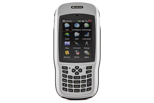
Topcon’s new T-18 unit offers advanced geopositioning capabilities
342 Topcon says that its new T-18 handheld controller offers accuracy for geopositioning, construction, mapping and vertical construction applications.  The controller includes a sunlight-readable display with a 1GHz processor, 1GB of internal storage, and up to 10 hours of battery life. “For MAGNET Field data collection, the T-18 controller offers a durable ergonomic solution with faster processing, a larger screen, better connectivity and longer battery life than previously available comparable systems,” said Ray Kerwin, director of global surveying products.


The T-18 features a 3.5G cellular modem for connectivity with Topcon MAGNET solutions for sending and receiving data to the cloud company account.  The firm says that the cellular option makes it easier to communicate with field crews when projects need to be changed or if important data is required back in the office. The modem can be used for RTK correction services. Additional key features include standard Bluetooth and Wi-Fi connectivity, as well as an IP65 rating for dust and water protection in demanding job site conditions.

For more information on companies in this article

Related Content

  • World Road Meeting 2017
    April 16, 2018
    The IRF World Road Meeting 2017 was held recently – World Highways’ India correspondent Partha Pratim Basistha reports The 18th World Road Meeting of the International Road Federation took place between 14-17 November 2017 in the North Indian state of Uttar Pradesh at Greater Noida near India’s capital New Delhi. Close to 1500 delegates and visitors across the world - including India - from the road infrastructure fraternity participated at the global event. The Cross Roads meeting, coinciding with an ex
  • Road and runway repair success
    July 2, 2012
    Fugro Aperio says it is improving the quality of road and airport runway repair techniques using its sophisticated ground penetrating radar (GPR) technology. The firm is now able to offer a combination of real time kinematic (RTK) GPS with multi channel radar systems due to partnerships with Yotta in the UK, and Pavement Management Services in Australia and the Middle East. This sophisticated package enables pre-planning of surveys, quicker execution and better positioning for more precise mapping of defect
  • Better drainage planning with QuAD software
    April 19, 2021
    The QuAD software resilience tool from ACO Water Management allows users to test the efficiency of a proposed maintenance regime for a roadway water channel design.
  • Trimble launches Site Positioning System Essentials Kit
    February 20, 2014
    Trimble has introduced a Site Positioning System designed for owner operators, small site contractors or construction companies new to GPS. The Trimble Site Positioning System Essentials Kit gives contractors proven Trimble quality and accuracy in an affordable and easy-to-use solution. The Essentials Kit is comprised of the new Trimble Site Mobile controller, Trimble SCS900 Site Controller Software and Trimble SPS985L GNSS Smart Antenna for a complete GPS positioning solution. Using GPS, a grade checker