Sophisticated geopositioning tool from Topcon

Topcon says that its new T-18 handheld controller offers accuracy for geopositioning, construction, mapping and vertical construction applications. The controller includes a sunlight-readable display with a 1GHz processor, 1GB of internal storage, and up to 10 hours of battery life. “For MAGNET Field data collection, the T-18 controller offers a durable ergonomic solution with faster processing, a larger screen, better connectivity and longer battery life than previously available comparable systems,” said
October 9, 2018 Read time: 2 mins
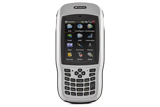
Topcon’s new T-18 unit offers advanced geopositioning capabilities
342 Topcon says that its new T-18 handheld controller offers accuracy for geopositioning, construction, mapping and vertical construction applications.  The controller includes a sunlight-readable display with a 1GHz processor, 1GB of internal storage, and up to 10 hours of battery life. “For MAGNET Field data collection, the T-18 controller offers a durable ergonomic solution with faster processing, a larger screen, better connectivity and longer battery life than previously available comparable systems,” said Ray Kerwin, director of global surveying products.


The T-18 features a 3.5G cellular modem for connectivity with Topcon MAGNET solutions for sending and receiving data to the cloud company account.  The firm says that the cellular option makes it easier to communicate with field crews when projects need to be changed or if important data is required back in the office. The modem can be used for RTK correction services. Additional key features include standard Bluetooth and Wi-Fi connectivity, as well as an IP65 rating for dust and water protection in demanding job site conditions.

For more information on companies in this article

Related Content

  • From Topcon comes a sophisticated mapping system
    February 8, 2013
    Topcon Europe Positioning says that its new IP-S2 Compact+ package is an innovative mobile mapping system that can accurately measure objects even in adverse weather conditions and enclosed job sites such as tunnels and mines. This replaces the earlier Topcon’s IP-S2 system, launched in 2009. The new vehicle-mounted system has improved scanner orientation to optimise visibility of roadside assets and is packaged in an affordable, compact system that fits on a car or truck. It offers full-colour, high-resolu
  • Piling accurately with Trimble’s new tool
    June 10, 2019
    Trimble is offering a new system that can help to boost the quality of drilling and piling work. The firm’s new Groundworks Machine Control System has been developed as a streamlined machine control solution for drilling and piling operations that helps optimise productivity and quality. The firm claims that this highly sophisticated system allows contractors to carry out drilling and piling operations more quickly, safely and accurately than using conventional methods. “Engineered for ease of use, Trim
  • Leica Geosystems wins prestigious UK contract
    March 9, 2012
    After an 18 month competitive tendering process, Leica Geosystems has been awarded the contract to supply over two hundred survey grade Leica Viva GS15 GNSS receivers to Ordnance Survey, the national mapping agency for Great Britain.
  • Sophisticated new rotating lasers from Topcon
    July 10, 2018
    Topcon Positioning Group is expanding its RL-H line of self-leveling rotating lasers. The RL-H5 series is said to be designed for high-accuracy and long working range in laser applications for grading, excavating and general construction projects. The new offering includes instruments to support diverse job site demands. The firm says that the RL-H5 series can be used for an array of tasks including machine guidance, checking grade, setting foundations and footings, checking excavations for pools, patios,