Site visibility with Volvo CE Connected Map

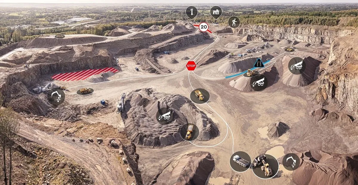
Connected Map will display many typical site features and landmarks, including roads, to help operators navigate the site.
By Guy Woodford April 16, 2024 Read time: 2 mins
Volvo CE Connected Map offers users complete visibility of their job site

Volvo Construction Equipment’s (Volvo CE) Connected Map provides complete visibility of the job site by giving a real-time visual overview of the position of every machine, vehicle and visitor on a customer's site.

The intelligent positioning service can be accessed by all site personnel, both in the machine (via Volvo Co-Pilot or an Android/iOS device) and in the office (via the Office portal).

Connected Map will display many typical site features and landmarks, including roads to help operators navigate the site, loading zones, unloading zones, speed zones and restricted areas. Points of interest such as offices, workshops, and service stations can also be visualised, which is particularly useful for new or temporary operators. Single-lane (narrow road) sections can be defined as warning the operator if another machine is approaching in a single-lane section, helping to avoid traffic jams.

Connected Map users can also stay informed about the location of their machines, thanks to Connected Map's search functionality, which will search and find users or machines in real-time, with the machine's last position visible for 30 days. Away from the office, Connected Map makes it easier for the operator to familiarise themselves with the site and know where everyone is, including visitors, helping to facilitate a simpler, safer and less stressful operation.

For more information on companies in this article

Related Content

  • Road construction software innovations
    February 13, 2012
    A range of key software innovations are now available for road construction applications from various suppliers - Adrian Greeman writes. Two significant and highly economic alternatives are now available to the major CAD providers both from Belgium and both offering interesting features. First is Pythagoras, which describes itself as a modern CAD program specially designed for topographical applications which include land surveying, road design and city planning.
  • Road savvy WIM prolongs highways and saves nations vital cash
    May 28, 2013
    A leading WIM system manufacturer is playing a key role in efforts to reduce the number of overloaded trucks costing developing economies around the world billions of dollars in accidents and damage to roads, while another company has won a major contract in South America. Guy Woodford reports. The prevalence of overloaded trucks on the road networks of developing countries and the accidents and structural damage they cause wastes valuable, limited resources in some of the world’s poorest economies, diverti
  • Permanent DMS in work zones
    February 9, 2012
    Forty-four state agencies currently rely on Daktronics for a total of more than 3,500 dynamic message signs (DMS) to provide important information to motorists. As soon as a new construction project begins, approaching motorists need to know exactly what to expect. Permanent DMS provide the information ahead of time, ahead of the congestion.
  • CONEXPO-CON/AGG 2017 planning for visitors
    January 6, 2017
    CONEXPO-CON/AGG and IFPE 2017 have released a new mobile app, powered by Caterpillar. This useful tool is designed to help attendees efficiently pre-plan their show visit and also stay connected onsite. The new CONEXPO-CON/AGG & IFPE show app is boosted by beacon technology and features interactive 3D contiguous maps to help attendees navigate the show floor. The show app continuously synchs to the online show planner where attendees can create a personalised agenda of exhibits, education and meetings, a