Site visibility with Volvo CE Connected Map

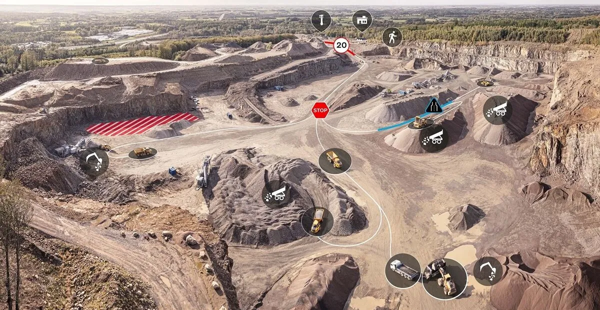
Connected Map will display many typical site features and landmarks, including roads, to help operators navigate the site.
By Guy Woodford April 16, 2024 Read time: 2 mins
Volvo CE Connected Map offers users complete visibility of their job site

Volvo Construction Equipment’s (Volvo CE) Connected Map provides complete visibility of the job site by giving a real-time visual overview of the position of every machine, vehicle and visitor on a customer's site.

The intelligent positioning service can be accessed by all site personnel, both in the machine (via Volvo Co-Pilot or an Android/iOS device) and in the office (via the Office portal).

Connected Map will display many typical site features and landmarks, including roads to help operators navigate the site, loading zones, unloading zones, speed zones and restricted areas. Points of interest such as offices, workshops, and service stations can also be visualised, which is particularly useful for new or temporary operators. Single-lane (narrow road) sections can be defined as warning the operator if another machine is approaching in a single-lane section, helping to avoid traffic jams.

Connected Map users can also stay informed about the location of their machines, thanks to Connected Map's search functionality, which will search and find users or machines in real-time, with the machine's last position visible for 30 days. Away from the office, Connected Map makes it easier for the operator to familiarise themselves with the site and know where everyone is, including visitors, helping to facilitate a simpler, safer and less stressful operation.

For more information on companies in this article

Related Content

  • Bentley Systems launches OpenRoads Designer CONNECT Edition
    April 13, 2017
    The beginning of this year saw Bentley Systems launch a major advanced comprehensive global tool for today’s increasingly widespread BIM environment. Christmas 2016 came early for Bentley's global clients. In fact, they had a hint of what was going to be under their tree come the celebrations in December. On November 1, at Bentley’s annual global client gathering and awards event Year in Infrastructure Conference in London, the solutions provider announced that OpenRoads Designer CONNECT Edition would be a
  • Florida gets one.network closure
    November 14, 2022
    Road crews in the US state of Florida can now post lane closure information to GPS providers from their mobile phones while working on site
  • Future earthmoving innovation from Volvo CE
    February 7, 2017
    Volvo CE is working on radical new concepts for earthmoving and extraction applications - Guy Woodford reports Volvo CE recently showcased a range of futuristic concepts and innovations from electromobility to intelligent machines and total site solutions at the company’s Xploration Forum in Eskilstuna, Sweden. Hundreds of Volvo Construction Equipment (Volvo CE) customers, members of the international press, government representatives and academics were given an exclusive look at a host of ground-breakin
  • GPS control delivers more accurate compaction performance
    July 13, 2012
    The latest compaction technology offers users the benefits of more accurate performance by combining heat detection and compaction metering with GPS In Europe several leading manufacturers now offer more accurate compaction technology, with Ammann, BOMAG, Dynapac and Hamm all having developed advanced control packages. The technologies vary widely but the advantages are broadly similar, with smart compaction allowing the user a greater degree of control over the compaction process and delivering major reduc