Site visibility with Volvo CE Connected Map

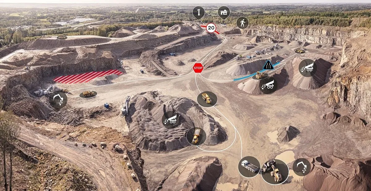
Connected Map will display many typical site features and landmarks, including roads, to help operators navigate the site.
By Guy Woodford April 16, 2024 Read time: 2 mins
Volvo CE Connected Map offers users complete visibility of their job site

Volvo Construction Equipment’s (Volvo CE) Connected Map provides complete visibility of the job site by giving a real-time visual overview of the position of every machine, vehicle and visitor on a customer's site.

The intelligent positioning service can be accessed by all site personnel, both in the machine (via Volvo Co-Pilot or an Android/iOS device) and in the office (via the Office portal).

Connected Map will display many typical site features and landmarks, including roads to help operators navigate the site, loading zones, unloading zones, speed zones and restricted areas. Points of interest such as offices, workshops, and service stations can also be visualised, which is particularly useful for new or temporary operators. Single-lane (narrow road) sections can be defined as warning the operator if another machine is approaching in a single-lane section, helping to avoid traffic jams.

Connected Map users can also stay informed about the location of their machines, thanks to Connected Map's search functionality, which will search and find users or machines in real-time, with the machine's last position visible for 30 days. Away from the office, Connected Map makes it easier for the operator to familiarise themselves with the site and know where everyone is, including visitors, helping to facilitate a simpler, safer and less stressful operation.

For more information on companies in this article

Related Content

  • Colas’s Yellow Project warns highway teams of collision risk
    November 7, 2017
    Colas’s Yellow Project has been developed with Aximum Electronic Products - a Colas Group Company - and software experts Foxstream. The system uses thermal imaging and video analytics to detect and classify approaching vehicles into “threat categories”. It identifies those that pose the greatest collision risk with a highway works vehicle or nearby workers. The thermal camera is mounted at height on the rear of a works or emergency vehicle and performs in both dark conditions and full sunlight. It does not
  • Using ITS to maximise safety and traffic flow for cycling
    January 22, 2013
    Copenhagen, Denmark, has long been known as one of the world’s leading cities for cycling. In some areas of the city, the modal share of bikes has reached a level of as much as 50 %. And on some of the most frequently used bike paths the average daily number of cyclists is close to 30,000. As these numbers continue to rise, new ways of planning and implementing cycling infrastructure are needed. Increasingly, Danish traffic planners are turning to technology as a tool for planning cycling infrastructure. I
  • Loading and hauling machine improvements will boost quarry production
    July 4, 2014
    Major advances are being seen in the market for loading and hauling machines, with manufacturers developing new solutions for the quarry segment in particular- Mike Woof writes Wheeled loaders and rigid chassis dump trucks are key movers in many quarry operations. New develop-ments have seen the introduction of several new models from key players.
  • Integrated corridor management offers transportation efficiency
    May 28, 2013
    In the Intelligent Transportation Systems world, the concept of managing roadway or transportation corridors is not new. Smart Corridor concepts have existed for some time, such as the Santa Monica Smart Corridor system from the 1990s. Across the world, a new emerging model for operating roadway transportation networks called integrated corridor management (ICM) has emerged. This is particularly true in California, where several new ICM projects have or are being deployed. There is a new paradigm for corrid