Site visibility with Volvo CE Connected Map

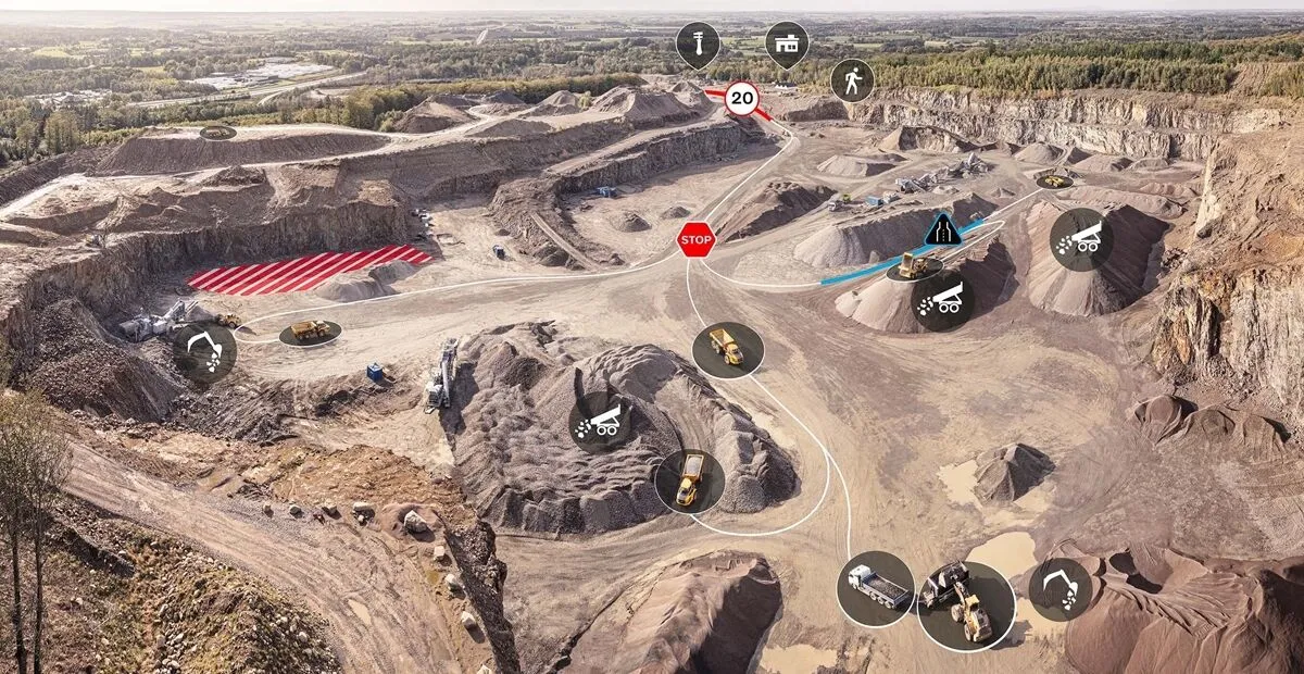
Connected Map will display many typical site features and landmarks, including roads, to help operators navigate the site.
By Guy Woodford April 16, 2024 Read time: 2 mins
Volvo CE Connected Map offers users complete visibility of their job site

Volvo Construction Equipment’s (Volvo CE) Connected Map provides complete visibility of the job site by giving a real-time visual overview of the position of every machine, vehicle and visitor on a customer's site.

The intelligent positioning service can be accessed by all site personnel, both in the machine (via Volvo Co-Pilot or an Android/iOS device) and in the office (via the Office portal).

Connected Map will display many typical site features and landmarks, including roads to help operators navigate the site, loading zones, unloading zones, speed zones and restricted areas. Points of interest such as offices, workshops, and service stations can also be visualised, which is particularly useful for new or temporary operators. Single-lane (narrow road) sections can be defined as warning the operator if another machine is approaching in a single-lane section, helping to avoid traffic jams.

Connected Map users can also stay informed about the location of their machines, thanks to Connected Map's search functionality, which will search and find users or machines in real-time, with the machine's last position visible for 30 days. Away from the office, Connected Map makes it easier for the operator to familiarise themselves with the site and know where everyone is, including visitors, helping to facilitate a simpler, safer and less stressful operation.

For more information on companies in this article

Related Content

  • Volvo CE’s arduous Andes assignment
    August 20, 2013
    Volvo Construction Equipment is working in some of the world’s most treacherous terrain to construct a high-speed road link across the Andes Mountains. A fleet of 60 Volvo Construction Equipment (Volvo CE) road-building machines is being used to construct a 140km highway across the Andes Mountains, from Bucaramanga, Colombia’s eighth largest city, to Cucuta on the border – providing the country with a much-needed high-speed link with Venezuela. Tasked with this huge undertaking is innovative Colombian highw
  • Volvo CE’s arduous Andes assignment
    August 20, 2013
    Volvo Construction Equipment is working in some of the world’s most treacherous terrain to construct a high-speed road link across the Andes Mountains. A fleet of 60 Volvo Construction Equipment (Volvo CE) road-building machines is being used to construct a 140km highway across the Andes Mountains, from Bucaramanga, Colombia’s eighth largest city, to Cucuta on the border – providing the country with a much-needed high-speed link with Venezuela. Tasked with this huge undertaking is innovative Colombian hi
  • Leica Geosystems new machine control tool
    February 7, 2017
    Leica Geosystems is aiming to improve compaction quality with its new machine control tool. The Leica iCON roller package can deliver benefits to both compaction quality and productivity. The package provides the compactor operator with an on-screen visualisation of completed passes, displaying where they have occurred and where more are needed for consistent results. The different colours on the display show the operator where work has been carried and to what degree. Using this system means that costly
  • Sophisticated plotting
    February 7, 2012
    Leica Geosystems is offering its improved SpiderWeb v4.0 package as part of the new reference station software update. This improved suite of solutions also includes the GNSS Spider v4.0 and SpiderQC v4.0 packages.