Site visibility with Volvo CE Connected Map

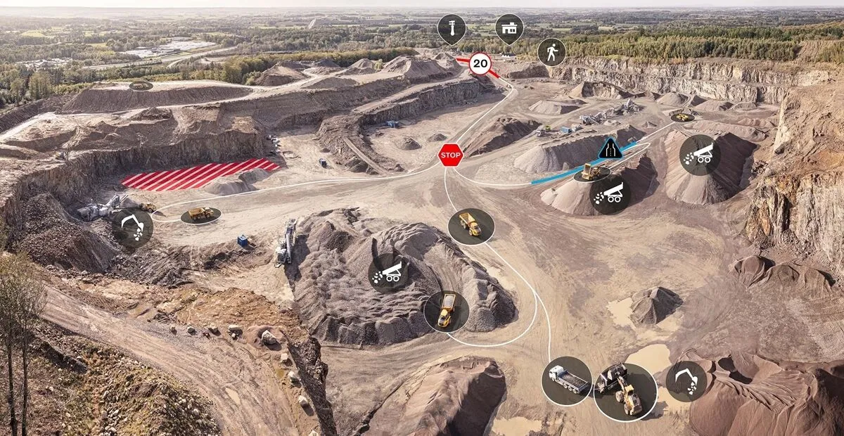
Connected Map will display many typical site features and landmarks, including roads, to help operators navigate the site.
By Guy Woodford April 16, 2024 Read time: 2 mins
Volvo CE Connected Map offers users complete visibility of their job site

Volvo Construction Equipment’s (Volvo CE) Connected Map provides complete visibility of the job site by giving a real-time visual overview of the position of every machine, vehicle and visitor on a customer's site.

The intelligent positioning service can be accessed by all site personnel, both in the machine (via Volvo Co-Pilot or an Android/iOS device) and in the office (via the Office portal).

Connected Map will display many typical site features and landmarks, including roads to help operators navigate the site, loading zones, unloading zones, speed zones and restricted areas. Points of interest such as offices, workshops, and service stations can also be visualised, which is particularly useful for new or temporary operators. Single-lane (narrow road) sections can be defined as warning the operator if another machine is approaching in a single-lane section, helping to avoid traffic jams.

Connected Map users can also stay informed about the location of their machines, thanks to Connected Map's search functionality, which will search and find users or machines in real-time, with the machine's last position visible for 30 days. Away from the office, Connected Map makes it easier for the operator to familiarise themselves with the site and know where everyone is, including visitors, helping to facilitate a simpler, safer and less stressful operation.

For more information on companies in this article

Related Content

  • Bomag is on track – London to Glasgow in 2 hours and 40 minutes
    July 1, 2022
    British Railways has big plans. Trains on the first 220 km from London Euston Station to Birmingham could be travelling at a speed of 360 km/h (225 mph) in as little as 10 years. The earthworks required for this are to be completed by as early as 2025. The project is considered one of the largest and most ambitious infrastructure projects in recent British history. It must meet the highest possible construction quality standards and evolve over the course of the project - setting new standards today and for tomorrow. The deployment of innovative BOMAG technologies and machines is therefore logical and consistent.
  • Weigh-in-motion key to maximising road life
    February 24, 2012
    The market and technology for weigh-in-motion systems continues to evolve – Mike Woof writes. for both mature and developing highway infrastructure networks, traffic densities play an important role in determining road wear and life. Monitoring traffic volumes and individual vehicle weight is crucial for ensuring roads can cope in the long term and that maintenance can be planned, while the problem of overloading can be eliminated.
  • Granite pilots Volvo’s Compact Assist to new heights in Sacramento
    November 9, 2017
    While not required for its Sacramento Airport contract, Granite Construction* is getting to grips with IC specifications thanks to Volvo CE’s Compact Assist. In the US, 23 states have written intelligent compaction (IC) specifications for asphalt paving jobs and more states are expected to follow. Among those states with IC specs is California.
  • Asset management and BIM solutions offer cost efficiency
    May 22, 2018
    New technology will help deliver projects more efficiently – Mike Woof writes. An array of new software and hardware tools are coming to market that can boost working efficiency for construction projects. Technology company thinkWhere is helping to improve collaboration and communication on Scotland’s largest road infrastructure project. Providing online access to multiple layers of live project maps and geographical data, the firm’s groundMapper software offers a web-based viewer that is allowing the co