Site visibility with Volvo CE Connected Map

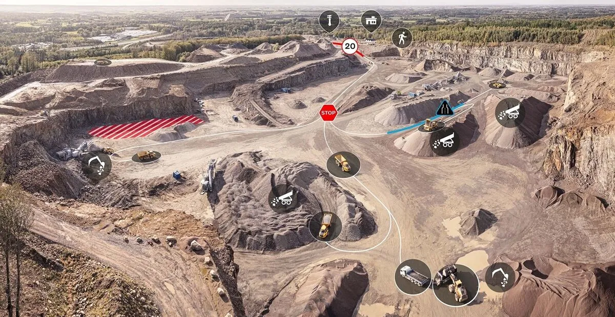
Connected Map will display many typical site features and landmarks, including roads, to help operators navigate the site.
By Guy Woodford April 16, 2024 Read time: 2 mins
Volvo CE Connected Map offers users complete visibility of their job site

Volvo Construction Equipment’s (Volvo CE) Connected Map provides complete visibility of the job site by giving a real-time visual overview of the position of every machine, vehicle and visitor on a customer's site.

The intelligent positioning service can be accessed by all site personnel, both in the machine (via Volvo Co-Pilot or an Android/iOS device) and in the office (via the Office portal).

Connected Map will display many typical site features and landmarks, including roads to help operators navigate the site, loading zones, unloading zones, speed zones and restricted areas. Points of interest such as offices, workshops, and service stations can also be visualised, which is particularly useful for new or temporary operators. Single-lane (narrow road) sections can be defined as warning the operator if another machine is approaching in a single-lane section, helping to avoid traffic jams.

Connected Map users can also stay informed about the location of their machines, thanks to Connected Map's search functionality, which will search and find users or machines in real-time, with the machine's last position visible for 30 days. Away from the office, Connected Map makes it easier for the operator to familiarise themselves with the site and know where everyone is, including visitors, helping to facilitate a simpler, safer and less stressful operation.

For more information on companies in this article

Related Content

  • Help is on hand from Roadtec’s Guardian Telematics
    August 17, 2015
    Telematics is giving contractors a greater oversight of the location and performance of their machinery In simple terms, telematics is any integrated use of telecommunications and ICT (information and communications technology). It concerns the sending, receiving and storing of information via telecommunication devices. Typically, this is in conjunction with machine or device control and includes use of global positioning systems, or GPS.
  • Seeing is believing: Bomag’s Digital Field Service
    April 27, 2018
    Bomag is customer-testing a new Digital Field Service has the potential to redefine onsite maintenance … globally. The focus here is not digitisation for its own sake. Rather, it is an attempt to reduce downtime by linking a maintenance operator on site, wearing a construction hard hat with a built-in camera and a “heads up” mini-screen in view, remotely guided by a Bomag expert back at the company’s headquarters. Problems on site can be talked through, whether the machine is 1km or 1,000km away. Bomag
  • New array of earthmoving machines
    August 7, 2020
    Several firms are introducing new earthmoving machines with increased performance
  • Life DYNAMAP: real-time mapping of road infrastructure noise
    October 15, 2015
    The world’s best road infrastructure project can also have the world’s worst traffic noise problem. But where to start defeating this noise pollution? Road traffic noise is one of the most obvious aspects affecting the quality of life in urban areas. To combat this, local, national and international authorities have developed initiatives to avoid, prevent or reduce exposure to noise. One of these initiatives – Life DYNAMAP – is underway by a group of researchers in Germany, Spain and Italy. The project is f