Site visibility with Volvo CE Connected Map

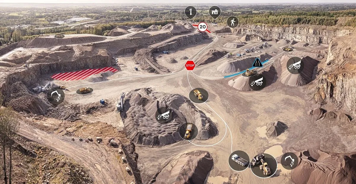
Connected Map will display many typical site features and landmarks, including roads, to help operators navigate the site.
By Guy Woodford April 16, 2024 Read time: 2 mins
Volvo CE Connected Map offers users complete visibility of their job site

Volvo Construction Equipment’s (Volvo CE) Connected Map provides complete visibility of the job site by giving a real-time visual overview of the position of every machine, vehicle and visitor on a customer's site.

The intelligent positioning service can be accessed by all site personnel, both in the machine (via Volvo Co-Pilot or an Android/iOS device) and in the office (via the Office portal).

Connected Map will display many typical site features and landmarks, including roads to help operators navigate the site, loading zones, unloading zones, speed zones and restricted areas. Points of interest such as offices, workshops, and service stations can also be visualised, which is particularly useful for new or temporary operators. Single-lane (narrow road) sections can be defined as warning the operator if another machine is approaching in a single-lane section, helping to avoid traffic jams.

Connected Map users can also stay informed about the location of their machines, thanks to Connected Map's search functionality, which will search and find users or machines in real-time, with the machine's last position visible for 30 days. Away from the office, Connected Map makes it easier for the operator to familiarise themselves with the site and know where everyone is, including visitors, helping to facilitate a simpler, safer and less stressful operation.

For more information on companies in this article

Related Content

  • 3D Repo develop virtual reality safety app for Balfour Beatty
    April 18, 2017
    3D Repo is working with contractors Balfour Beatty and Vinci and the UK roads agency Highways England to deploy a virtual reality simulation program for safety training. 3D Repo, a spin-off from University College London, develops open-source software for building information modelling in the cloud. More than 40 different 3D file formats are decomposed and federated in the company’s big data repository.
  • Testing advanced compaction technology
    April 6, 2020
    Contractor Max Bögl and BOMAG have worked together on a major infrastructure project in Germany to carry out practical tests of the BW 174 Hybrid and BOMAP system.
  • Think smart with RM XSMART
    July 13, 2022
    The launch of XSMART, by Rubble Master, is the next step towards the future digital construction site, explains Gerald Hanisch*, the company’s chief executive, and Markus Gaggl, the chief technical officer
  • How data mining and the intelligence it creates is helping sites run more effectively and efficiently
    December 13, 2022
    In this, the third in our series of top-level roundtable discussions led by World Highways, editor Mike Woof and roundtable host Nadira Tudor talk machine control technology with three world-class experts from Leica Geosystems (part of Hexagon), Topcon, and Trimble. There’s never been a more exciting time to be in construction as innovation makes us more productive, more efficient, more sustainable, and better connected. Autonomy means opportunity.