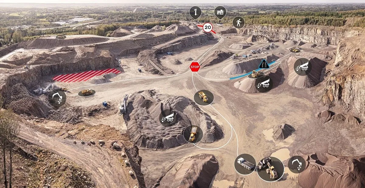
Site visibility with Volvo CE Connected Map

Connected Map will display many typical site features and landmarks, including roads, to help operators navigate the site.
By Guy Woodford April 16, 2024 Read time: 2 mins
Volvo CE Connected Map offers users complete visibility of their job site

Volvo Construction Equipment’s (Volvo CE) Connected Map provides complete visibility of the job site by giving a real-time visual overview of the position of every machine, vehicle and visitor on a customer's site.

The intelligent positioning service can be accessed by all site personnel, both in the machine (via Volvo Co-Pilot or an Android/iOS device) and in the office (via the Office portal).

Connected Map will display many typical site features and landmarks, including roads to help operators navigate the site, loading zones, unloading zones, speed zones and restricted areas. Points of interest such as offices, workshops, and service stations can also be visualised, which is particularly useful for new or temporary operators. Single-lane (narrow road) sections can be defined as warning the operator if another machine is approaching in a single-lane section, helping to avoid traffic jams.

Connected Map users can also stay informed about the location of their machines, thanks to Connected Map's search functionality, which will search and find users or machines in real-time, with the machine's last position visible for 30 days. Away from the office, Connected Map makes it easier for the operator to familiarise themselves with the site and know where everyone is, including visitors, helping to facilitate a simpler, safer and less stressful operation.

For more information on companies in this article

Related Content

  • Variable message signs deliver real time travel information
    April 10, 2012
    Variable Message Sign systems are helping ease traffic congestion and keeping drivers better informed on key highways across Europe and the rest of the world. Guy Woodford looks at some of their recent applications By coupling its Intelligent Travel Time System (ITTS) with Bluetooth technology, Alcatel-Lucent is measuring traffic flow in real time and conveying it seamlessly to local authorities in the French city of Vélizy-Villacoublay. The city, a major business enterprise hub 14km south-west of central
  • Smarter paving option from Vögele
    December 12, 2018
    Vögele is extending its range of service and training options for users with the introduction of a new app and web facility. This is said to allow paving crews to get to grips with the ErgoPlus 3 operating concept quickly and easily with the aid of numerous animations. The tool allows users to learn how to position and adjust the screed, as well as retrieve paving programmes. Using the system allows operators to achieve optimum paving results and efficient job site processes, according to the firm. The sy
  • Powerful machine control technology
    February 14, 2012
    THE TRIMBLE TSC3 handheld controller for construction is said to offer powerful and rugged control capabilities. This hand-held unit is aimed at duties with heavy and highway contractors and features builtin GPS, 3G, Wi-Fi and a 5 megapixel digital camera. The unit is said to allow site workers to stay connected and also provides accurate positioning and digital design information. Using this unit allows engineers to locate, measure and record information anywhere on the construction site with a single devi
  • Laser scanning focuses on asset management
    January 9, 2015
    Laser scanners and improved data collection and analysis software are making light of asset management surveying. David Arminas reports The age of the laser scanner is upon us, taking over from traditional manual methods of surveying, data collection and processing. These new technical developments are making it much easier to process and use the data captured and are providing highways engineers with powerful tools to record, map and visualise their assets. This is good news for highways authorities