Precision pinpointing

Leica Geosystems says that its TS30 package is a new high precision Total Station that meets highest standards in all surveying applications. Distances can now be measured with Leica Geosystems' proven PinPoint EDM Technology with an unprecedented precision of 0.6mm + 1ppm on prisms. On natural surfaces a high accuracy of 2mm + 2ppm up to 1,000m can be achieved.
March 1, 2012 Read time: 2 mins
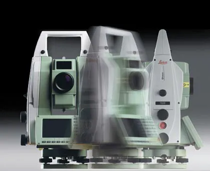
Precise positioning is possible with the new TS30 package from Leica Geosystems
265 Leica Geosystems says that its TS30 package is a new high precision Total Station that meets highest standards in all surveying applications. Distances can now be measured with Leica Geosystems' proven PinPoint EDM Technology with an unprecedented precision of 0.6mm + 1ppm on prisms. On natural surfaces a high accuracy of 2mm + 2ppm up to 1,000m can be achieved.

New direct drives using piezo technology were developed for the Leica TS30, allowing high tracking performance, with maximum acceleration and speed while maintaining accuracy under demanding conditions. This new technology allows automated one-person surveying and higher productivity.

Combined with the firm's Leica SmartWorx software, users can set the package up as a Leica TS30 SmartStation with the latest future proof GNSS antenna to provide immediate station coordinates. With the GNSS antenna on top of the 360° prism as a SmartPole, quick and accurate set-up can be achieved on-the-fly.

Features of the TS30 include long service intervals and low power consumption as well as a durable construction to withstand severe environments. The piezo drives allow for longer operation through low power consumption with sophisticated power management.

For more information on companies in this article

Related Content

  • Sophisticated technology allows milling accuracy
    January 14, 2021
    Given the increase in vehicle numbers and that modern vehicles are heavier, it is more important for modern highways to be constructed to higher standards than previously.
  • 3D PAVING comes to India and is boosting slipforming efficiency
    December 19, 2016
    Situated on India’s northern frontier, the state of Jammu and Kashmir is world-renowned for its aesthetic vistas and captivating landscapes. The arterial roads connecting the city of Jammu to that of Srinagar is a challenge to maintain, being constantly exposed to harsh weather and overburdened with vehicular movement. Leica Geosystems has been involved in the Chenani-Nashri tunnel project, India’s longest road tunnel and which will be part of an alternate route in the region
  • Data handling for efficient machine control
    October 16, 2012
    The rapid increase in information availability is transforming the construction sector. Conventional methods used for sourcing geographic data based on maps and localised sampling meant that there was often a lack of accurate information relating to ground conditions at specific areas where work was planned, often resulting in unwelcome surprises for construction companies along with additional costs for projects.
  • Topcon’s new survey solution
    October 27, 2016
    Topcon Positioning Group’s new surveying suite features four integrated solutions, comprising three hardware products and a single software system. The firm says that this package provides users with a powerful survey system. The Topcon Elite Survey Suite includes the new GT series of robotic total stations, HiPer HR hybrid GNSS receiver, FC-5000 field computer and MAGNET 4.0 software system. According to Topcon, users can benefit from advanced geo-positioning products and technology in one system.