Precision pinpointing

Leica Geosystems says that its TS30 package is a new high precision Total Station that meets highest standards in all surveying applications. Distances can now be measured with Leica Geosystems' proven PinPoint EDM Technology with an unprecedented precision of 0.6mm + 1ppm on prisms. On natural surfaces a high accuracy of 2mm + 2ppm up to 1,000m can be achieved.
March 1, 2012 Read time: 2 mins
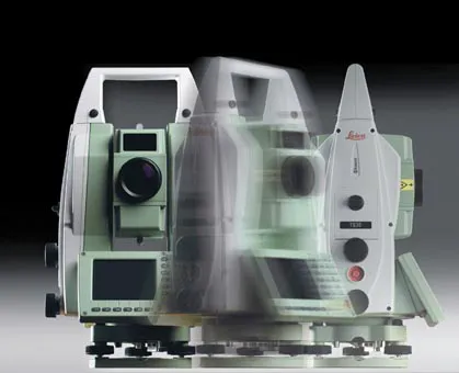
Precise positioning is possible with the new TS30 package from Leica Geosystems
265 Leica Geosystems says that its TS30 package is a new high precision Total Station that meets highest standards in all surveying applications. Distances can now be measured with Leica Geosystems' proven PinPoint EDM Technology with an unprecedented precision of 0.6mm + 1ppm on prisms. On natural surfaces a high accuracy of 2mm + 2ppm up to 1,000m can be achieved.

New direct drives using piezo technology were developed for the Leica TS30, allowing high tracking performance, with maximum acceleration and speed while maintaining accuracy under demanding conditions. This new technology allows automated one-person surveying and higher productivity.

Combined with the firm's Leica SmartWorx software, users can set the package up as a Leica TS30 SmartStation with the latest future proof GNSS antenna to provide immediate station coordinates. With the GNSS antenna on top of the 360° prism as a SmartPole, quick and accurate set-up can be achieved on-the-fly.

Features of the TS30 include long service intervals and low power consumption as well as a durable construction to withstand severe environments. The piezo drives allow for longer operation through low power consumption with sophisticated power management.

For more information on companies in this article

Related Content

  • Topcon’s action station
    October 31, 2012
    Topcon Europe Positioning (TEP) has launched a new, professional-grade robotic total station – the PS series – which the firm says is designed to surpass the power, accuracy and capabilities of its peers. The PS is said to utilise Topcon’s new PowerTrac technology to increase the prism tracking power. “Using new optics, laser system and advanced algorithms, PowerTrac provides the PS with the ability to keep tracking a moving prism even under the toughest environmental conditions,” said Leighton Davies, surv
  • Sophisticated plotting
    February 7, 2012
    Leica Geosystems is offering its improved SpiderWeb v4.0 package as part of the new reference station software update. This improved suite of solutions also includes the GNSS Spider v4.0 and SpiderQC v4.0 packages.
  • Leica Vivo portfolio expansion
    February 18, 2013
    Leica Geosystems has expanded its Leica Viva portfolio with the Leica Viva GS14, said to be an exceptional and deployment versatile GNSS receiver. The Viva GS14 has a compact design with integrated communication devices. Along with the dependable GNSS RTK, the Viva GS14 is said to deliver complete confidence and knowledge in results. Useable as a robust yet lightweight rover and as a base station, Leica’s new GNSS receiver allows users to gain speed and efficiency by reducing the number of setups and contro
  • Accurate deformation monitoring from Leica Geosystems
    March 7, 2017
    Leica Geosystems is now offering a sophisticated tool that allows engineers to measure deformation accurately. The Leica GeoMoS Now! Survey Edition is a service for monitoring and managing 3D deformation of points of potentially unstable areas for surveying projects. It has a streamlined workflow and can deliver monitoring reports of man-made structures or natural dangers to smart devices. Surveyors can use this to upload coordinates, process and visualise deformations, allowing other users to access result