Picture perfect from Leica

Advanced imaging capability has been added to the Leica ScanStation C10 laser scanner. The new option consists of a direct digital camera mount on the ScanStation C10 scanner and tight, automated integration of external camera images into the scanner’s on-board controller and data storage system. Cyclone v7.4 supports the new option.
July 18, 2012 Read time: 2 mins
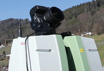
Advanced imaging capability has been added to the Leica ScanStation C10 laser scanner.

The new option consists of a direct digital camera mount on the ScanStation C10 scanner and tight, automated integration of external camera images into the scanner’s on-board controller and data storage system. Cyclone v7.4 supports the new option.

265 Leica Geosystems (LG) said ScanStation C10 users will continue to have the option of using the scanner’s convenient, embedded camera for taking precisely aligned, high-resolution digital pictures of the surrounding scene.

The company’s ScanStation C5 with internal camera option can also be used with the new external camera option.

With the growing popularity of powerful point cloud viewing software capabilities like TruView, Cyclone TruSpace, and fly-through movies, users are said by LG to be increasingly taking advantage of high-end external camera imagery with point cloud data.

Previously, applying such quality external imagery involved removing a scanner head from its tripod; placing a high-end camera on the same tripod; taking 360º full-dome pictures; and then using third party software tools to apply the full dome imagery to the point cloud data. This method added up to15-30 minutes per scanner setup. The new integrated, automated external camera option is said to cut the total time to less than 5 minutes per setup. With dozens of setups a day typical, the new option saves many hours each day. New commands for the integrated, external camera facility are in ScanStation C10 firmware v2.70.

Meanwhile, optional external camera support exists for an 18 Megapixel Canon EOS 60D camera. An External Camera Mounting Kit includes a bracket for this camera that conveniently attaches to the ScanStation C10’s removable carry handle slot, plus a USB cable that connects the camera to the scanner for camera control from the scanner and for automatic image transfer.

In addition to supporting the new External Camera option, Cyclone 7.4 also has the ‘Gradient Display’ point cloud display feature. It provides users with several gradient display backgrounds for point clouds, such as a blue sky and brown ground in places where there is no point cloud data, making the appearance of point cloud data more familiar to new users.

For more information on companies in this article

Related Content

  • Leica’s growing support network
    April 23, 2013
    Leica Geosystems has launched Leica Zeno Office v3.1 and Leica MobileMatriX v5.1 software updates for the Zeno GIS series. Leica Zeno Office v3.1 and MobileMatriX v5.1 now support the new Leica CS25 GNSS, an innovative tablet computer and high accuracy data collector; Esri ArcGIS 10.0/10.1; and post-processing accuracy improvements. Johannes Hotz, senior product manager, says: “Both Zeno Office, in combination with Leica Zeno Field, and MobileMatriX further support the measurement of positions and associate
  • Leica’s high-tech 5
    August 14, 2012
    The new Leica Zeno 5 is said to be an entrylevel, rugged personal digital assistant (PDA) for organisations that require a durable compact device with integrated modem and high-sensitive GPS. The Leica Geosystems technology supports field workers by combining a mobile phone with asset collection and management capabilities. The Leica Zeno 5 is said to be shock resistant, withstands a drop from to 1.8m, and is protected against water and dust. The large 9.4cm screen is optimised for sunlight readability and
  • Leica’s new Digicat xf-Series cable locators and transmitters
    April 3, 2013
    Leica Geosystems has launched the latest additions to the Digisystem product range: the Leica Digicat xf-Series. With Leica Geosystems’ new xf-Series cable locators and transmitters, users are said to be able to accurately detect and trace utilities faster and over a greater distance. The Leica Digicat xf-Series is said by the Swiss firm to have been speci?cally designed with long distance tracing in mind. The ability to trace transmitter frequencies of 512Hz and 640Hz provides users with a greater tracing
  • Leica’s GMX901plus GNSS receiver
    May 13, 2014
    The Leica GMX901plus is said by the Swiss firm to be an “affordable and rugged” GNSS receiver that delivers precise and reliable data about movements of sensitive structures such as mine walls, rock slopes, dams, and buildings. For time-critical applications that require high rate data and a higher accuracy the GMX901plus can be smoothly upgraded to a powerful L1/L2 GPS/GLONASS receiver with an update rate of 5Hz.