Advanced imaging capability has been added to the Leica ScanStation C10 laser scanner.
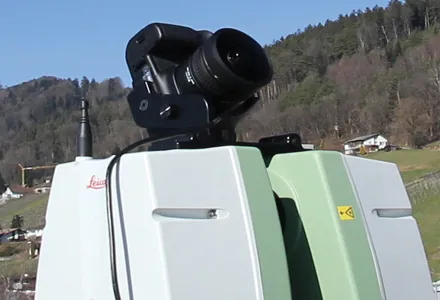
The new option consists of a direct digital camera mount on the ScanStation C10 scanner and tight, automated integration of external camera images into the scanner’s on-board controller and data storage system. Cyclone v7.4 supports the new option.
Advanced imaging capability has been added to the Leica ScanStation C10 laser scanner.
The new option consists of a direct digital camera mount on the ScanStation C10 scanner and tight, automated integration of external camera images into the scanner’s on-board controller and data storage system. Cyclone v7.4 supports the new option.The company’s ScanStation C5 with internal camera option can also be used with the new external camera option.
With the growing popularity of powerful point cloud viewing software capabilities like TruView, Cyclone TruSpace, and fly-through movies, users are said by LG to be increasingly taking advantage of high-end external camera imagery with point cloud data.
Previously, applying such quality external imagery involved removing a scanner head from its tripod; placing a high-end camera on the same tripod; taking 360º full-dome pictures; and then using third party software tools to apply the full dome imagery to the point cloud data. This method added up to15-30 minutes per scanner setup. The new integrated, automated external camera option is said to cut the total time to less than 5 minutes per setup. With dozens of setups a day typical, the new option saves many hours each day. New commands for the integrated, external camera facility are in ScanStation C10 firmware v2.70.
Meanwhile, optional external camera support exists for an 18 Megapixel Canon EOS 60D camera. An External Camera Mounting Kit includes a bracket for this camera that conveniently attaches to the ScanStation C10’s removable carry handle slot, plus a USB cable that connects the camera to the scanner for camera control from the scanner and for automatic image transfer.
In addition to supporting the new External Camera option, Cyclone 7.4 also has the ‘Gradient Display’ point cloud display feature. It provides users with several gradient display backgrounds for point clouds, such as a blue sky and brown ground in places where there is no point cloud data, making the appearance of point cloud data more familiar to new users.