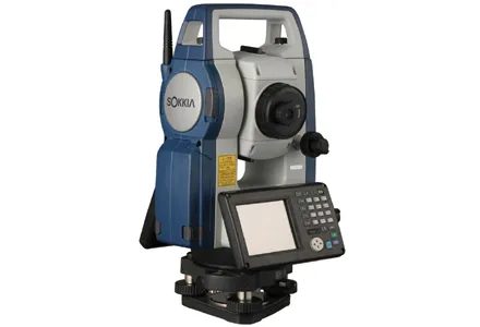
Topcon Positioning says that its DS-200i direct-aiming motorised imaging station is compatible with the new Autodesk BIM 360 Layout app for the Apple iPad. The DS-200i is the second total station solution that Autodesk and Topcon have collaborated on for contractors.
Topcon says that the BIM 360 Layout app’s connectivity with the DS-200i offers a reflectorless solution along with imaging and increased vertical range over previous systems. The DS-200i has an electronic distance measurement (EDM) range of

Topcon says that the BIM 360 Layout app’s connectivity with the DS-200i offers a reflectorless solution along with imaging and increased vertical range over previous systems. The DS-200i has an electronic distance measurement (EDM) range of up to 1km without the need of a prism, and 5km with one. The built-in wireless WLAN connects the iPad with the BIM 360 Layout app.
The two firms say that this collaboration offers contractors the ability to connect a coordinated model to the field layout process, helping to increase job site productivity while improving the accuracy of staked or installed building components.
The DS-200i also offers a reflectorless solution for QA/QC (quality assurance, quality control) workflows. This can help verify that items in the field are installed correctly as compared to models.
The DS-200i features real-time video imaging with its 5 MP camera. The controller’s touchscreen video and arrow keys are designed to let remote operators view what is being measured, in a similar way to looking through the telescope.
The Autodesk BIM 360 Layout app is available from the Apple App Store.