Sick UK says its new LMS500 family of laser sensors achieves new levels of high-speed and consistent performance in adverse highway conditions. “The incontrovertible rule in laser measurement used to be – if you can’t see it, the laser can’t see it, but with the LMS500 this is no longer true,” said Tim Stokes, SICK UK laser sensor specialist. “These hard-working sensors ignore spray, smoke and dust and cope with rain, snow, ice and fog. They will operate reliably for applications such as vehicle spacing, sp
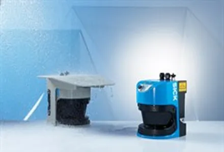
“The incontrovertible rule in laser measurement used to be – if you can’t see it, the laser can’t see it, but with the LMS500 this is no longer true,” said Tim Stokes, SICK UK laser sensor specialist.
“These hard-working sensors ignore spray, smoke and dust and cope with rain, snow, ice and fog. They will operate reliably for applications such as vehicle spacing, speed and separation, load monitoring and automated tolls.”
Stokes said the LMS500 sensors can be quickly networked to synchronise multiple slave sensors useful, for example, when scanning vulnerable points of large installations such as toll booths.
The LMS500 is said to use a unique five-echo technology, combined with a very small radius (3.6mrad) spot, to ignore irrelevant signals that would distract sensors of lower capability. With five echoes per pulse, multiple objects at different distances in the field are also said to be detected offering greater security and safety.
LMS500 Series (Pro and Lite ranges) is said by Sick UK to offer customers a broad selection of models, resolutions and configurations to match application requirements and budgets. The sensors have a range of up to 80 metres, with a 1900 field and 100Hz scanning frequency said to enable rapid detection and evaluation.
The sensors have an IP67-protected modular design and a built-in heater. The multiple I/Os and powerful software platform combine self-monitoring and auto-calibration with up to 10 programmable fields per unit; an Ethernet interface and USB connections meet connectivity and configuration requirements. Power offtake is also said to be low.
“SICK introduced the world’s first 2D laser scanner,” added Stokes. “It started the laser sensor revolution that enabled customers in all sorts of industries to achieve new productivity and security. Now the LMS500 elevates scanning technology to a new level of speed, accuracy and consistent availability.”