
Highway condition monitoring move

Geospatial surveying specialist Yotta DCL now has a contract with Southampton City Council for road surface condition monitoring and is using its advanced laser technology. Yotta DCL is surveying 300km of the city's roads using its sophisticated ARAN survey vehicle which uses innovative laser scanning and precision GPS systems. These surveys are operating as part of a UK Government-specified programme called Surface Condition Assessment for the National Network of Roads (SCANNER). This will provide the city
August 2, 2012 Read time: 2 mins
Yotta's sophisticated, Canadian-developed pavement monitoring technology can identify road repair needs quickly
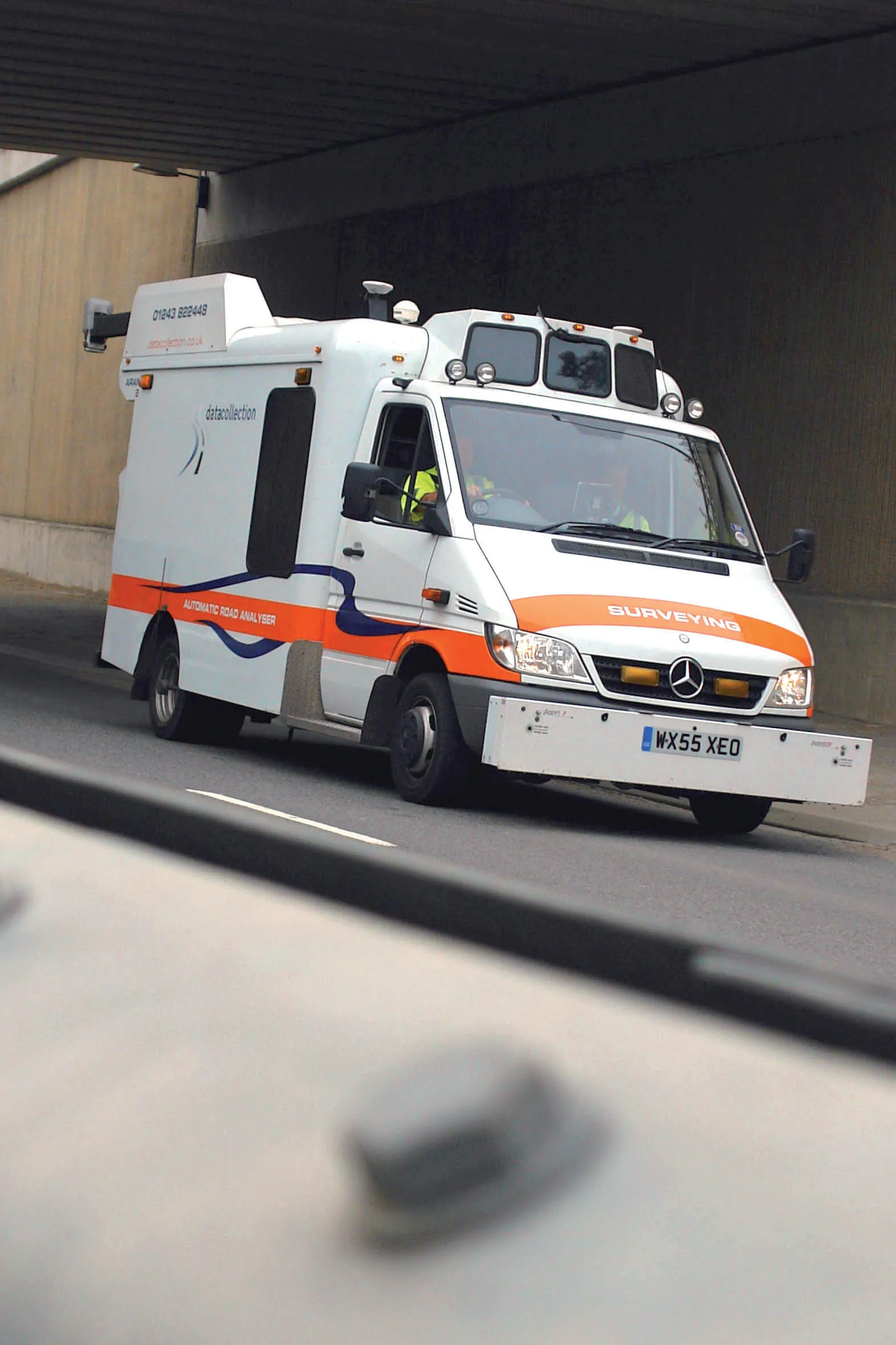
Geospatial surveying specialist 5153 Yotta DCL now has a contract with 3548 Southampton City Council for road surface condition monitoring and is using its advanced laser technology. Yotta DCL is surveying 300km of the city's roads using its sophisticated ARAN survey vehicle which uses innovative laser scanning and precision GPS systems. These surveys are operating as part of a UK Government-specified programme called Surface Condition Assessment for the National Network of Roads (SCANNER). This will provide the city with accurate data that will allow the highway team to plan maintenance programmes and budgets more effectively. The highly specialised ARAN vehicle is an Anglo-Canadian development equipped with an advanced surface laser scanner that captures surface data with its precise location identified by a military-grade satellite positioning system. The accurate location information allows the survey data to be matched with other highways data such as records from on-foot highways defects surveys. Data captured by the ARAN vehicle shows defects such as wheelpath rutting, edge deterioration and cracks as well as the road geometry and longitudinal profile.

For more information on companies in this article

Related Content

  • Fugro wins 3-year pavement assessment contract with UK council
    December 13, 2012
    Fugro has secured a three-year contract with Luton Borough Council in southern England to provide a range of highway and footway investigations, including the Council’s annual SCANNER surveys using Fugro’s ARAN (Automatic Road Analyser) survey system. The survey package also includes SCRIM (surface friction) testing of Luton’s A, B and C roads, and CVI (coarse visual inspection) of unclassified roads. Cambridge-based Fugro transport specialists will process the survey data to generate NI (national indicator
  • Latest GIS and software tools improve operations
    February 24, 2012
    Innovative GIS and software solutions are coming to market from the three key market players - Mike Woof reports Competition is strong in the field for GIS and surveying systems as well as the associated software. The three major players in the sector, Leica Geosystems, Topcon and Trimble, all invest heavily in research and development and continue to roll out new solutions for construction customers that will boost the efficiency of surveying as well as overall project implementation.
  • Gritty decisions need Smart Modelling
    May 27, 2022
    Mark Fisher, principal strategic consultant with Amey Consulting, explains how its data-led Smart Winter modelling improved a UK local government’s winter gritting efficiency by 18%
  • Rapid adoption of GPS machine control
    April 5, 2012
    The high sophistication of GPS machine control systems has resulted in a fast pace of technological advancement. The three major players in the machine control sector, Leica Geosystems, Topcon and Trimble have all made major gains in recent years. The sophistication of the latest systems can combine satellite position data from the GPS and GLONASS networks with information from total stations to provide precise, high speed machine operation. Further more the firms have also prepared themselves for the intro