Fast field data collection

Trimble's sophisticated TSC3 controller is designed to allow surveyors and geospatial professionals to collect, share and deliver data. This unit is said to improve accuracy, efficiency and productivity between the field and office and is designed to be used with the Trimble Access software. The TSC3 controller offers fast and reliable data collection, computing and connectivity capabilities and provides multiple functions in a single handheld device. The unit incorporates a digital camera, integrated commu
February 10, 2012 Read time: 2 mins
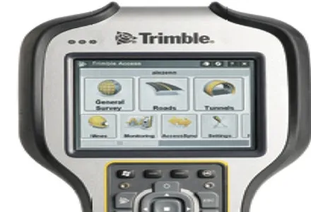
2122 Trimble's sophisticated TSC3 controller is designed to allow surveyors and geospatial professionals to collect, share and deliver data. This unit is said to improve accuracy, efficiency and productivity between the field and office and is designed to be used with the Trimble Access software. The TSC3 controller offers fast and reliable data collection, computing and connectivity capabilities and provides multiple functions in a single handheld device. The unit incorporates a digital camera, integrated communications as well as a GPS navigator, compass and accelerometer.

Using this device, surveyors can include on-site photos in surveys, communicate efficiently between field and office and streamline stakeout activities. The durable Trimble TSC3 controller has a high-resolution, sunlight-readable touchscreen display, integrated Wi-Fi and Bluetooth wireless capabilities and long battery life. Users can also choose either a QWERTY or ABC alphanumeric keyboard.

Delivered with Trimble Access software installed as well as the capability to run third-party applications on the Windows platform, the TSC3 is a comprehensive data collection solution for the survey industry. The Trimble TSC3 controller has wireless Internet connectivity through either the integrated GSM/GPRS modem or Wi-Fi. Data collection, processing, analysis, and delivery duties are said to be faster and more efficient.

For more information on companies in this article

Related Content

  • More accurate mapping
    July 31, 2024

    Trimble and Radiodetection have established a collaboration to improve the technology used in the utility measurement and mapping process. Through the integration of the Trimble Catalyst DA2 GNSS system and Radiodetection’s RD MapTM+ application and precision locator products, the software and hardware integration streamlines utility-locating workflows. This can provide high-accuracy measurement capabilities for the generation of underground utilities maps in a single field operation. 

  • Connectivity is key for contractors
    November 8, 2022
    Michigan Department of Transportation (MDOT) has planned its US$210 million I-69 Rebuild Project in Eaton and Calhoun Counties, work that will improve journeys for drivers in the area
  • Accurate deformation monitoring from Leica Geosystems
    March 7, 2017
    Leica Geosystems is now offering a sophisticated tool that allows engineers to measure deformation accurately. The Leica GeoMoS Now! Survey Edition is a service for monitoring and managing 3D deformation of points of potentially unstable areas for surveying projects. It has a streamlined workflow and can deliver monitoring reports of man-made structures or natural dangers to smart devices. Surveyors can use this to upload coordinates, process and visualise deformations, allowing other users to access result
  • Efficient asset management delivers
    April 25, 2013
    Maximising the economic benefit of infrastructure assets can be achieved through delivering better quality maintenance. Increasing utilisation of infrastructure follows on from those assets being in better condition. Clearly by tracking infrastructure condition closely, huge gains can be made in addressing technical issues before they become more serious and more costly, as well as minimising disruption. In UK city Birmingham, high resolution aerial photography from Bluesky is helping the city council under